A Few of the Mysteries
The Grand Canyon and Other Canyons. See Figure 1.
Mid-Oceanic Ridge. This 46,000-mile-long ridge, discovered in the 1950s, is the world’s longest mountain range. It wraps around the Earth on primarily a great-circle path. [See Figure 2 on page 121.] Unlike most mountains, it is composed of a type of rock called basalt. Because most of the ridge lies on the ocean floor, relatively few people know it exists. How did it get there? Why is it primarily on the ocean floor? Why does it intersect itself in a Y-shaped junction in the Indian Ocean? The portion in the Atlantic Ocean is called the Mid-Atlantic Ridge. Is it just a coincidence that it splits the Atlantic from north to south and is generally perpendicular to and bisected by the equator? If Europe, Africa, and the Americas were once connected, how did they break apart?
Cutting across the Mid-Oceanic Ridge, at almost right angles, are hundreds of long cracks, called fracture zones. Whenever the axis of the Mid-Oceanic Ridge is offset, it is always along a fracture zone. [See Figure 3 on page 122.] Why? According to plate tectonics, plates move parallel to fracture zones. But fracture zones are not always parallel. Sometimes they are many degrees “out of parallel.” 6 How then can solid plates be bounded by and move in the direction of these fracture zones? (Can a train move on tracks that aren’t parallel?) Notice the white arrows in Figure 3 showing nearly intersecting fracture zones.

Figure 4: Overlapping Spreading Centers. Bold lines represent the axes of the Mid-Oceanic Ridge. According to plate tectonics, the ocean floor is moving in the direction of the white arrows—away from the Mid-Oceanic Ridge. If so, in which direction is point B moving? If B is stationary, and A is moving east, why is there no fault between them? What is happening at C and D if the plate tectonic theory is correct? Obviously, the seafloor is not spreading. Later, these overlaps will be shown to support the hydroplate theory.
In at least eight places on the Atlantic and Pacific floors, segments of the Mid-Oceanic Ridge overlap for about 10 miles. They are called overlapping spreading centers.7 [See Figure 4.] If plates are moving away from the Mid-Oceanic Ridge, then the distance between overlapping segments must be increasing. However, overlapping regions are always near each other—contradicting plate tectonics.
Earth’s Major Components. What accounts for Earth’s oceans, continents and their boundaries (shelves and slopes), crust, mantle, and core (inner and outer)? Why are the shapes of continental shelves and slopes so uniform worldwide? [See Figures 2 and 5 and Figure 87 on page 157.]
Low-salinity water is being discovered far below continental shelves worldwide. Why would water, typically less salty than seawater, be found beneath the seafloor? 8
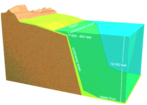
Figure 5: Continental Margin—the typical shape of ocean-continent boundaries worldwide. The actual continental boundary is generally considered to be halfway down the continental slope. Compare this figure with Figure 2 on page 121, and notice that Asia and North America would become connected if sea level was lowered about 300 feet. Australia and Asia would be almost connected. Sediments and sedimentary rock are shown in yellow.
With so much ice on the continents during the height of the ice age (a few centuries after the flood), sea level was temporarily about 400 feet lower than it is today. Therefore, land animals and humans could then have easily migrated between all continents.
Ocean Trenches. Concentrated on the floor of the western Pacific are more than a dozen ocean trenches—long, narrow depressions, some of which are several times deeper than the Grand Canyon. [See Figures 2, 3, and 83.] Believers in plate tectonics claim that a trench forms when a continental-size plate dives down into the mantle at a 30°–60° angle below the horizontal—a process they call subduction. How this dive begins is never explained.
The initiation of subduction remains one of the unresolved challenges of plate tectonics. [See Endnote 106 on page 199.]
This would be similar to pushing a 30-mile-thick shovel a thousand miles into the ground.

Figure 6: Magnetic Anomalies. Notice the fluctuations in magnetic intensity as one moves across the Mid-Oceanic Ridge. The so-called reversals are simply regions of lower magnetic intensity. Why is the intensity greatest along the crest of the ridge?
Magnetic Variations on the Ocean Floor. At a few places along the Mid-Oceanic Ridge, magnetic patterns on one side of the ridge are almost a mirror image of those on the other side. As you will see, the plate tectonic theory gained wide acceptance in the 1960s by also misinterpreting this surprising discovery.
Some proposed that these variations were caused by periodic reversals of Earth’s magnetic field, although there is no theoretical understanding of how that could happen.9 Supposedly, if seafloor spreading occurs over millions of years, molten material moves away from the ridge, and the magma solidifies, locking in the orientation of Earth’s magnetic field at the time. Thus, a record of past “flips” of Earth’s magnetic field is preserved in rocks at different distances from the ridge—if Earth’s magnetic field periodically flips and the seafloor is spreading.
That explanation is wrong, as detailed magnetic maps clearly show. No compass, shielded from Earth’s magnetic field, would reverse direction whenever it crossed an alleged (and misleading) reversed band. However, as one moves across the Mid-Oceanic Ridge, magnetic intensities fluctuate, as shown in Figure 6. Someone merely drew a line through these fluctuations and labeled everything below this average intensity as a “reversal.” There is a false but widespread impression that these slight deviations below the average represent magnetic fields that reversed millions of years ago. Calling these fluctuations reversals causes one to completely miss a more likely explanation.
Although textbooks show these so-called “reversals” as smooth bands paralleling the Mid-Oceanic Ridge for thousands of miles, there is nothing smooth about them. Some “bands” are even perpendicular to the ridge axis—the opposite of what plate tectonics predicts. Also, the perpendicular “bands” correspond to fracture zones.10 The hydroplate theory explains these magnetic anomalies. [See “No Seafloor Spreading” on page 183.]
A few lava flows show that rapid but limited changes in Earth’s magnetic field have occurred. Lava cools at known rates, from the outside of the flow toward its center. Magnetic particles floating in lava align themselves with the Earth’s magnetic field. When the lava cools and solidifies, that orientation becomes fixed. Knowing this cooling rate and measuring the changing directions of the magnetic particles within several solidified lava flows shows that at one time, Earth’s magnetic field shifted rapidly—by up to 6 degrees per day for several days.11 (Note: This does not mean Earth’s magnetic field flips every few million years.)
Submarine Canyons. The ocean floor has hundreds of canyons, some that exceed the Grand Canyon in both length and depth. One submarine canyon is ten times longer (2,300 miles), so long it would stretch nearly across the United States.12 Many of these V-shaped canyons are extensions of major rivers. Examples include the Amazon Canyon, Hudson Canyon, Ganges Canyon, Congo Canyon, and Indus Canyon. How were canyons gouged out, sometimes 15,000 feet below sea level? Did ancient rivers (or major drainage paths) cut these canyons when sea level was lower, or the ocean floor was higher? If so, why did those elevations change? Swift rivers supposedly cut most continental canyons. However, currents measured in submarine canyons are too slow, generally less than one mile per hour. Frequently, the flow is in the wrong direction. Submarine landslides that produce dense, muddy currents sometimes occur. However, they would not form the long, tributary patterns that characterize river systems and submarine canyons. Furthermore, experiments with thick, muddy water in submarine canyons have not demonstrated any canyon-cutting ability.
Coal and Oil Formations. Why are large fossilized trees found near the North and South Poles?13 In Antarctica, some fossilized trees are 24 feet long and 2 feet thick! Nearby are 30 layers of anthracite (high-grade) coal, each 3– 4 feet thick.14 Buried redwood forests, with trees more than 100 feet long and root structures showing that they grew in place, are found on Canadian islands well inside the Arctic Circle.15 Oil deposits are also inside the Arctic Circle. Was it once warm enough for trees to grow in Antarctica or inside the Arctic Circle? If so, how could so much vegetation grow where it is nighttime 6 months of the year? Were these cold lands once at temperate latitudes? Not according to plate tectonics, which places both regions near their present latitudes when their now-fossilized forests were growing.16
Methane Hydrates. Some bacteria can live without oxygen. When they feed on organic material, they release methane gas, a combustible fuel. In 1970, vast quantities of methane—the largest source of buried carbon in the world—were discovered inside ice mixed within sediments lying up to 2,000 feet or more below sea level but near coastlines.17 The ice molecules form microscopic cagelike structures, each encasing one or more methane molecules. The total energy value of this methane-ice combination, called methane hydrate, is at least twice that of all the world’s known coal and oil combined ! 18

Figure 7: Flaming Ice. This ice burns, because it contains methane, a flammable gas. How did that happen? Water freezes at slightly warmer temperatures than normal if it is under high pressure and contains dissolved methane. Such temperatures and pressures exist 2,000 feet or more below sea level. There, on and under the deep seafloor, are vast methane deposits trapped in ice—primarily along the world’s coastlines. How did so much methane get there? What was its source, and why is it along coastlines?
Why is so much methane buried along coastlines? How did all the bacteria, that produced the methane, get there, and what was their gigantic source of food? The largest known deposit, named “Hydrate Ridge,” lies off Oregon’s coast. According to plate tectonics, that part of the seafloor is sliding under North America and should be removing the methane hydrates. However, methane hydrates lie along all coastlines worldwide, whether those plates are supposedly subducting or not. [See Figure 7.]
Ice Age. An ice age implies extreme snowfall, which, in turn, requires cold temperatures and heavy precipitation. Heavy precipitation can occur only if oceans are warm enough to produce heavy evaporation. How could warm oceans exist with cold atmospheric temperatures?
Another problem is stopping an ice age once it begins—or beginning a new ice age after one ends. As glaciers expand, they reflect more of the Sun’s radiation away from Earth and lower temperatures, causing glaciers to grow even more. Eventually, the entire globe should freeze permanently. Conversely, if glaciers shrink, as they have in recent decades, the Earth will reflect less heat into space, warm-up, and eventually melt all glaciers.

Figure 8: Buckled Mountain. Textbooks and museums frequently refer to some uplifting force that formed mountains. Can you see that an uplifting force, by itself, would not produce this pattern? Horizontal compression was needed to buckle these sedimentary layers near the Sullivan River in southern British Columbia, Canada. Such layers—seen worldwide—must have been soft, like wet sand, at the time of compression. Today, surface rocks are brittle and cannot bend.
Don’t be misled by claims that there are hundreds of thousands of layers of glacial ice, so the ice age began hundreds of thousands of years ago. Yes, ice cores extracted from deep in glaciers in Antarctica and Greenland have many layers, but the eye can count less than 2,000 annual layers, because the weight of the overlying layers compressed all the layers below. They are now so thin that the eye can no longer count them.
Those who claim there are hundreds of thousands of layers, create mathematical models in which some characteristic of the ice core (such as dust content, acidity, or various chemical isotopes) is measured along every millimeter of the core’s length. Then, mathematical curves having hundreds of thousands of cycles are fit to the data. Missing is the statistical analysis showing that the fit is significant—that the data (such as dust content, acidity, or the variation pattern of oxygen-18) is not random noise. If laymen are not impressed by the claim that it took 800,000 “years” to lay down, all those cycles, those same laymen may be impressed by the technical jargon describing the oxygen-18 or acidity measurements. Hidden is the simple fact that less than 2,000 true annual layers can be counted—even with magnification.19
Major Mountain Ranges. How did mountain ranges form, and why they often crumpled like an accordion? [See Figure 8.] Satellite photos of mountain ranges show that some resemble a throw rug pushed against a wall. But what force could push a long, thick slab of rock and cause it to buckle and sometimes fold back on itself? Any force pushing on a long, thick slab of rock 8 miles or longer will crush the pushed end before movement could even begin. Therefore, a mountain would not form. [See “Key Requirements for Folding Strata, Buckling Mountains, and Overthrusting” on page 204.]
We can see, especially in mountains and road cuts, thinly layered rocks folded like doubled-over phone books, without stretching the tiny, crystalline grains in those folds. Other “bent” rocks are small enough to hold in one’s hand. How could brittle rock, showing little evidence of heating or cracking, fold? Rocks are strong in compression but weak in tension, so their stretched outer surfaces should have fractured. Bent sedimentary rocks, found worldwide, often look like compressed and folded layers of wet sand. Obviously, they were squeezed and folded soon after the mushy sediments were laid down, but before they hardened chemically. What squeezed and folded them?
Frozen Mammoths. Fleshy remains of about 50 elephant-like animals called mammoths, and a few rhinoceroses, have been found frozen and buried in Siberia and Alaska. One mammoth still had identifiable food in its mouth and digestive tract. To reproduce this result, you would need to suddenly push a well-fed elephant (dead or alive) into a huge freezer whose temperature was-150°F. Anything less severe would result in the animal’s internal heat and stomach acids destroying its food. If the animal remained alive for more than a few minutes, one would not expect to find food in its mouth. What could cause such a large and sudden temperature drop? Even if the Sun suddenly stopped shining, Earth’s temperature would not drop rapidly enough to produce such effects. Finally, you would need to burry your elephant in frozen ground—quite a trick.
How could large herds of elephant-like animals, each requiring much food, live in the Arctic? Even if the Arctic were warm, the lack of winter sunlight would allow far less vegetation to grow than is needed to sustain so many large animals. Today, the average January temperature in northern Siberia is -28°F. Your nose gets cold after a few minutes in +32°F weather. Consider how you would feel if your nose were a 6-foot-long trunk, and the average temperature was a frigid 60°F colder for weeks. Where would you, or a mammoth, find drinking water?
Overthrusts. For over a century, geologists have struggled unsuccessfully to explain overthrusts—large blocks of rock, hundreds of feet thick and hundreds of miles long, that have slid horizontally over other rocks for 50 miles or more. Such blocks should have considerable rubble under them. Many have none. Pushing a large slab of rock with enough force to overcome the gigantic friction would crush the slab before it would move. Those who appreciate this problem simply say that the pore pressure of water in rocks must have lubricated the sliding, as the slab slid downhill. But rocks do not contain nearly enough water to do this, and overthrusted blocks are seldom on steep slopes.
Volcanoes and Lava. Erupting lava usually exceeds 2,000°F. Where does it come from, and why is it so hot? Earth’s mantle and inner core are essentially solid. Only the outer core, which lies 1,800 – 3,200 miles below the Earth’s surface, is a liquid. The standard explanation is that lava (called magma when it is inside the Earth) originates in hot pockets, called magma chambers, at depths of about 60 miles, but how did it get there? Then, how could magma escape to the surface? A key fact to remember is that at depths greater than about 5 miles, pressures are so great that all empty channels through which magma might rise should be squeezed shut.20 Even if a crack could open, the magma must rise through colder rock. Unless this happened quite rapidly, magma would cool, solidify, and plug up the crack. Also, heat diffuses. So, what concentrated enough heat to create the “hot pockets” and melt vast volumes of rock that erupted in the past?
On the Columbia Plateau in the northwestern United States, 64,000 square miles of lava, with an average depth of 2/3 mile, spilled out rapidly underwater.21 On the Deccan Plateau in western India, lava flooded 200,000 square miles to an average depth of 3/4 mile. In southwestern Siberia, lava deposits are many times larger. Four times more magma spilled out on the Ontong-Java Plateau (on the floor of the western Pacific) than on the Deccan Plateau. How did so much magma form, and how did it get out?
Two of the world’s deepest drill holes are on the Kola Peninsula in northern Russia and in Germany’s northeastern Bavaria.22 They were drilled to depths of 7.6 miles and 5.7 miles, respectively. Deep in the Russian hole, to everyone’s surprise, was hot, salty water flowing through crushed granite.23 Why was the granite crushed? In the German hole, the drill encountered cracks throughout the lower few miles. All cracks contained saltwater with salt concentrations about twice that of seawater. Remember, surface waters cannot seep deeper than 5 miles, because the weight of overlying rock squeezes shut even microscopic flow channels.20
This deep saltwater mystifies geologists. Another surprise was the greater-than-expected increases in the granite’s temperature with increasing depth—so much so that each drilling project terminated early. This raises the question of why the Earth’s crust is so hot. The hydroplate theory provides a simple answer.
Geothermal Heat. Heat inside the Earth is called geothermal heat. The deeper man has gone into the Earth—first in deep caves and mines and later with drills—the hotter the rock generally gets. What is the origin of geothermal heat? Students are frequently told that the Earth slowly grew (evolved) by meteoritic impacts that melted the Earth, so geothermal heat is what remains after billions of years.

Figure 9: Granite and Basalt. Granite, the primary continental rock, has a grayish-to-pinkish color. Coarse grains of quartz, which have a glassy luster, occupy about 27% of granite’s volume. Basalt, the most common rock beneath oceans today, is solidified lava—a dark, fine-grained rock. The hydroplate theory assumes that before the flood, granite was above the subterranean water, and the mantle was below. As you will see, during and after the flood, molten basalt spilled out onto the chamber floor, so most ocean floors today are paved with basalt.
This popular story has several problems. First, the rate of temperature increase with depth, called the temperature gradient, varies, even in rock far from volcanoes, by at least a factor of six.24 If the Earth has been cooling for billions of years, one would expect very uniform temperature increases with depth at most locations. Unusually hot or cold regions should not exist, because heat diffuses from hotter to colder regions.
Mathematical solutions for heat conduction in spheres, such as the Earth, are well known. These solutions can incorporate many facts, including the Earth’s thermal properties, radioactive heat generation, and temperatures at the Earth’s surface. Such analyses are hopelessly inconsistent with the “molten-Earth” story and “billions of years of cooling.” [See “Molten Earth?” on page 33 and “Rapid Cooling” on page 44.] What then generated geothermal heat, and why does it still vary so widely?
Strata. Earth’s crust is frequently stratified with layered rock (or strata) composed of cemented sediments. These layers are typically parallel, thin, uniform in thickness, vast in area, and, within mountains and under valleys, tipped at all angles. Often one layer rests on another having a completely different texture, color, and mineral content. What global process sorted and cemented these sediments? Present processes do not.
Why are strata so uniform in hardness? If truckloads of sand and other dry sediments were dumped on your yard and bags of cement were placed in another pile, anyone would have difficulty mixing them uniformly. Without a uniform mixture of cementing agent, concrete (and sedimentary rock) would quickly crumble.
Limestone. A typical cementing agent in sedimentary rock is calcium carbonate (CaCO3)—commonly called limestone. Any geologist who stops to think about it should realize that, based on present processes, the Earth has too much limestone. Sediments and sedimentary rock on the continents average about a mile in thickness and contain 10–15% limestone.25 How did so much limestone form—much of it quite pure? Limestone, without the impurities that normally drift in, suggests rapid burial. Most limestone is in vast layers, tens of thousands of square miles in area and hundreds of feet thick. Today, limestone forms either as it precipitates out of seawater or as sea creatures manufacture shells and corals containing limestone. In either case, oceans supply limestone sediments, but oceans already contain about as much dissolved limestone as they can possibly hold. So, where did all the limestone come from, especially its calcium and carbon, which are relatively rare outside of limestone?
Metamorphic Rock. Rocks change structurally and chemically when their temperatures and/or pressures exceed certain high values. The new rock is called a metamorphic rock. For example, limestone becomes marble (a metamorphic rock) when its temperature exceeds 1,600°F and confining pressures correspond to the weight of a 23-mile-high column of rock. Diamonds, another metamorphic rock, form under confining pressures corresponding to the weight of a 75-mile-high column of rock and 1,600°F, yet diamonds are found in crustal rocks that were never deep.26 Most metamorphic rocks were formed in the presence of water, often flowing water.27 What accounts for the extreme temperature, pressure, and abundance of water needed to form metamorphic rock?
The standard answer is that the original rock, such as limestone, was heated and compressed under a tall mountain or deep in the Earth. Later, over millions of years, either the mountain eroded away or the deep rock rose to Earth’s surface. It is difficult to imagine mountains 23 or 75 miles high, because the world’s tallest mountain, Mount Everest, is only 5 1/2 miles high. Raising buried layers of rock 23 or 75 miles to the Earth’s surface is even more difficult to explain, but with millions of years supposedly available, few consider the problem. Most don’t know of the problem, and almost no one addresses it.
Plateaus. Plateaus are relatively flat regions of extensive area that have been uplifted (not buckled) more than 500 feet relative to surrounding regions. A plateau contains nearly horizontal rock layers. The same vertical sequence of horizontal layers surrounds the plateau, but at a lower elevation. Professor George C. Kennedy clearly explains some problems associated with lifting plateaus hundreds of feet.
Figure 10: Continental Fit Proposed by Bullard. Can you identify five distortions in this popular explanation of how the continents once fit together? First, Africa was shrunk in area by 35%. Second, Central America, southern Mexico, and the Caribbean Islands were removed. Third, Australia is ignored, because its fit anywhere is problematic—and where is Asia? Fourth, a slice was made through the Mediterranean, and Europe was rotated counterclockwise and Africa was rotated clockwise. Finally, North and South America were rotated relative to each other. Notice the rotation of the north-south and east-west lines. Scientific justifications are not given for any of these five distortions.
Overlapping areas are shown in black and gaps in the fit are in white. If a supercontinent simply broke apart, what did the breaking, and how could the pieces (plates) move? Each plate should be locked by friction to the rock it rested on? What accounts for the gaps and overlaps? Evidently, something wore away the edges of the plates after the supercontinent broke into plates.
Do you suppose that water, trapped below the crust, isolated each plate from what would otherwise be its rock foundation, and allowed the plates to move to where they are today? If so, that water, in escaping violently upward would have eroded the edges of the plates, producing the overlaps and gaps.

The problem of the uplift of large plateau areas is one which has puzzled students of the Earth’s crust for a very long time. ... Given an Earth with sialic [granitic] continents floating in denser simatic [basaltic] substratum, what mechanism would cause a large volume of low standing continents to rise rapidly a mile in the air? Furthermore, evidence from gravity surveys suggests that the rocks underlying the Colorado plateau are in isostatic balance, that is, this large area is floating at its correct elevation in view of its mass and density. Recent seismic evidence confirms this, in that the depth to the M discontinuity [the Moho, explained below] under the Colorado plateau is approximately 10 kilometers [6 miles] greater than over most of continental North America. Thus, appropriate roots of light rock extend into the
Figure 11: Poor Fit. Notice that the fit of the actual continents is not as good as Bullard proposed. [See Figure 10.]
The Tibetan plateaus present a similar problem, but on a vastly larger scale. There, an area of 750,000 square miles has been uplifted from approximately sea level to a mean elevation of roughly three miles, and the Himalayan mountain chain bordering this region has floated upward some five miles, and rather late in geologic time, probably within the last 20,000,000 years. The quantity of light rock which would need to be swept underneath these plateaus by convection currents to produce the effects noted would be an order of magnitude greater than that needed to uplift the
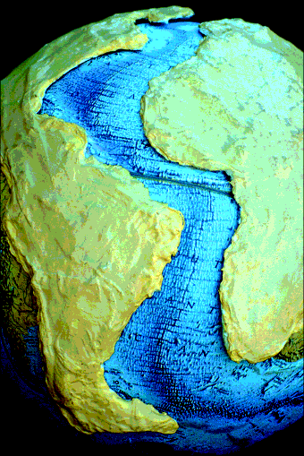
Figure 12: Best Fit. By far the best fit of these continents is against the base of the Mid-Atlantic Ridge—not as shown in Figure 11. The distortions of Figure 10 are unnecessary and deceptive.
The Moho and Black Smokers. The Mohorovicic discontinuity, usually called the Moho, is the boundary between Earth’s crust and mantle. The Moho was discovered in 1909 by seismologist Andrija Mohorovicic. He noticed that earthquake waves travel noticeably faster below the Moho than above. In the early 1960s, efforts were made to drill deep enough to penetrate and examine the Moho, but cost overruns and alleged mismanagement shut the project down after drilling only 601 feet into the seafloor. Today, drilling efforts are finding that above the Moho the “rock has been thoroughly fractured and is saturated with water; free water normally cannot migrate down to those depths!” 29 What is the Moho, why is the rock above fractured, and why does it contain liquid water? Figure 14 describes black smokers.
Salt Domes. Vast salt layers are sometimes buried as much as several miles below Earth’s surface. Under the Gulf of Mexico is a single salt layer, called “the mother salt layer.” It is at least 20,000 feet below sea level, 100,000 square miles in area, and 1,000 feet thick! 30 Many tall salt domes rise several miles above the mother salt layer; some salt domes are taller than Mount Everest! Large salt deposits are not being laid down today, even in the Great Salt Lake. What concentrated so much deep salt? Certainly, 20,000 feet of water did not evaporate.
A thicker “mother salt layer” with dozens of salt domes is also found under the Mediterranean Sea. A codiscoverer of these deposits, using refuted arguments,31 claims that the Mediterranean must have evaporated 8–10 times to deposit so much salt.32 His estimate is probably low, but even so, why didn’t each refilling of the Mediterranean Basin redissolve the salt residue left from prior evaporations, allowing currents to remove the basin’s salt?
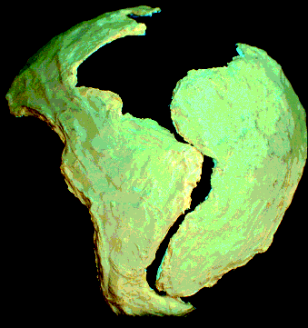
Jigsaw Fit of the Continents. For centuries, beginning possibly with Francis Bacon in 1620, many have noticed the approximate jigsaw fit of the continents bordering the Atlantic. It is only natural that bold thinkers, such as Alfred Wegener in 1915, would propose that the continents were once connected as shown in Figure 10, and somehow they broke apart and moved to their present positions. But would continents, including their broad but submerged continental shelves, really fit together as shown in textbooks? Distances are distorted when a globe is flattened into a two-dimensional map. Therefore, to answer this question, I formed two plates on a globe, matching the true shape and curvature of the continents. [See Figure 12.]
The classical fit (Figure 10), proposed by Sir Edward Bullard, appears at first glance to be a better fit of the continents than my plates. However, notice in Figure 10’s description the great “latitude” Bullard took in juggling continents. Were these distortions made to improve the fit? Few, if any, textbooks inform us of these distortions.
Instead of fitting the continents to each other, notice in Figure 12 how well they each fit the base of the Mid-Atlantic Ridge. The hydroplate theory proposes that:
a. These continents were once in the approximate positions shown in Figure 12.
b. They were connected by rock that was rapidly eroded and transported worldwide by erupting subterranean water.
c. As these eroded sediments were deposited, they trapped and buried plants and animals. The sediments became today’s sedimentary rock, and buried organisms became fossils.
d. The continents quickly slid on a layer of water (rapid continental drift) away from the rising Mid-Atlantic Ridge and toward the subsiding Pacific floor. They came to rest near their present locations.
Details and evidence will be given later in this chapter.
Layered Fossils. Fossils rarely form today, because dead plants and animals decay before they are buried in enough sediments to preserve their shapes. Nor do we see fossils forming in layered strata that can be traced over thousands of square miles. How, then, did so many fossils form? It will soon become apparent why animals and plants were trapped and buried in tens of millions of cubic miles of sediments that were quickly cemented to form the fossil record and why fossils of sea life are found on every major mountain range.
Changing Tilt of Earth’s Axis. George F. Dodwell served as the Government Astronomer for South Australia from 1909 to 1952. In the mid-1930s, he became interested in past changes in the tilt of the Earth’s axis. He collected almost 100 astronomical measurements made over a 4,000-year period. Those measurements show that the tilt of the Earth’s axis smoothly decayed from 25°10' to its present value of 23°27'. Based on the shape of the decay curve, Dodwell estimated that this axis shift began recently.36
The gravitational forces of the Sun, Moon, and planets do change the tilt of the Earth’s axis, but much more slowly than the changes Dodwell measured. An extraterrestrial body striking the Earth would provide an abrupt change in axis orientation, not the smooth changes Dodwell measured. Also, only a massive and fast asteroid striking the Earth at a favorable angle would tilt the axis that much. However, the resulting pressure pulse would pass through the entire atmosphere and quickly kill most air-breathing animals—a recent extinction without evidence.
Comets, Asteroids, and Meteorites. These strange bodies, sometimes called “the mavericks of the solar system,” have several remarkable similarities with planet Earth. They contain considerable water. (About 38% of the mass of comet Tempel 1 is frozen water.37) Water is rare in the universe, but both common and concentrated on Earth—often called “the water planet.” Most of the remaining mass of a comet is dust, primarily the crystalline mineral olivine. Solid material that formed in space would not be crystalline. Olivine may be the most abundant of the more than 2,500 known minerals in Earth’s crust and mantle. Asteroids and meteorites are similar in many ways to Earth rocks. Surprisingly, a few meteorites contain salt crystals, liquid water, and living bacteria!38 Some asteroids have a chemical substance (kerogen) found in plants.
Earth’s Radioactivity. Few people realize that the origin of Earth’s radioactivity and the heavier chemical elements have never been explained.33 Furthermore, radiometric dating assumes that radioactive decay rates have always been constant. A careful understanding of the flood will show how and why Earth acquired its heaviest chemical elements and radioactive materials, and why the “constant rate” assumption (and, therefore, radiometric dating) is grossly in error. This understanding will also show (1) just how powerful the fountains of the great deep were and (2) how the flood destroyed the Earth in ways that are still being felt.
Summary. These are a few of the mysteries associated with the 25 topics listed on page 120. The hydroplate theory will explain these mysteries and tie together the causes and effects of this dramatic, global catastrophe.