How to Evaluate Theories
To explain an unobserved, unrepeatable event scientifically, we must first assume the conditions existing before that event. From these assumed starting conditions, we then try to determine what should happen according to the laws of physics. Three criteria should be used to evaluate the proposed explanation: Process, Parsimony, and Prediction.
Criterion 1: Process. If, from these starting conditions, we can explain all relevant observations better than any other proposed explanation, confidence in our explanation increases. However, if these starting conditions and the operation of physical laws would have produced any result that is not present, then confidence in our explanation decreases.
For example, a frequent and intriguing question is, “What caused the extinction of the dinosaurs?” (We will not answer that question now, but will use it to show how to evaluate scientific theories attempting to explain unobserved and unrepeatable events.) Some dinosaur extinction theories assume large climate changes. While many types of climate variation might kill all dinosaurs, we must also (by Criterion 1) look at other consequences of that large climate changes. Flowering plants and many small animals are more vulnerable to large climatic changes than dinosaurs. Because most plants and animals did not become extinct with the dinosaurs, “climatic change” theories for dinosaur extinctions are weakened.
Criterion 2: Parsimony. (Parsimony here means “the use of few assumptions.”) If a few assumptions allow us to explain many things, then confidence in the explanation will be great. Conversely, if we need to make many assumptions to explain a few observations, or if new observations cause us to modify our proposed theory, then we should have little confidence in the explanation.
For example, some say that a large asteroid or comet struck the Earth and killed all the dinosaurs. Supposedly, the asteroid or comet, containing the rare element iridium, kicked up a worldwide dust cloud that blocked sunlight for several years, reduced photosynthesis on Earth, and choked off the dinosaurs’ food chain. Support for this theory comes from layers of clay, containing iridium, in Europe, New Zealand, and elsewhere. Iridium-rich layers sometimes contain dinosaur fossils and, based on evolutionary assumptions, are about 65-million years old.
This one starting condition (an impact of a large asteroid or comet) may explain two important observations: dinosaur extinctions and iridium layers. This is good. But there are some hidden assumptions. While most meteorites contain iridium, asteroids or comets contain little, if any, iridium. Advocates of the impact theory must assume that asteroids or comets have large amounts of iridium (or that meteorites came from comets or asteroids). Other iridium-rich layers have since been discovered too far above and below the layer thought to mark the extinction of the dinosaurs. Further studies have found few iridium-rich layers near known impact craters. (Scientists have recently learned that airborne particles expelled by volcanoes also contain considerable iridium.)39
Also, many marine plants require daily sunlight.40 How could they have survived a global dust cloud that killed the dinosaurs? Each problem might be solved by adding new assumptions. However, by Criterion 2, this lowers our confidence in the theory.
Criterion 3: Prediction. A legitimate theory allows us to predict unusual things we should soon see if we look in the right places and make the right measurements. Verified predictions greatly increase our confidence in an explanation. Published predictions are the most important test of any scientific theory, which is why this book contains 58 published predictions based on the hydroplate theory of the flood. page 479 summarize all 58. Few evolutionists make predictions that can be tested within a thousand years.
What predictions can be made based on the “climate variation” and “impact” theories? Few, if any, have been made publicly. This does not inspire confidence in these explanations. Rarely do predictions accompany explanations of ancient, unobserved events. But the impact theory can make some predictions. For example, there should be a huge impact crater whose age corresponds to the time of the extinction of the dinosaurs. Fossils of many forms of life should be concentrated in and around that crater or, at least, in the hemisphere containing the crater. However, dinosaur fossils are found throughout the earth,41 so the cause of dinosaur extinction was global in reach, a point worth remembering.
For several years, no suitable crater could be found.42 Finally, in 1990, an impact site was proposed on Mexico’s Yucatán Peninsula, centered near the village of Chicxulub (CHICK-shoo-loob). Evolutionists initially dated the site as 40 – 50-million years before dinosaurs became extinct. No crater shape was visible, but a buried crater was claimed based on slightly circular magnetic and gravitational patterns, some imagination, and a desire to explain dinosaur extinctions. Impact advocates then redated the region and, in effect, predicted that drilling in and around Chicxulub would reveal an iridium layer and a buried impact crater. Controversy still rages as to whether a crater is present.43
Other dinosaur extinction theories have even more problems. Our purpose in this section is not to settle this issue but to show how scientific reasoning can address unobserved, nonreproducible events. Incidentally, another theory on dinosaur extinction will soon become obvious—a theory involving a global flood and the harsh conditions afterward. [For more on dinosaurs, see “What about the Dinosaurs?” on page 493.]
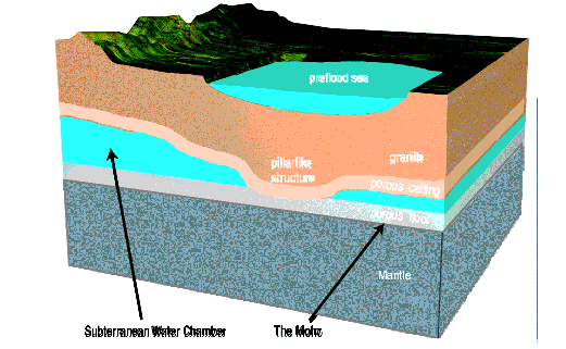
Figure 13: Cross Section of the Preflood Earth. (Not to scale.) Notice several aspects of the early Earth. The thickness of the subterranean water chamber varied, because the chamber’s granite roof sagged and pressed against the chamber floor at locations that will be called pillars, although they were not shaped like the cylindrical pillars we see in buildings today. Pillars partially supported the roof. (The confined, high-pressure subterranean water below provided most of the support.) [Pages 469– 474 explain how, why, and when pillars formed.]
Supercritical water (SCW) in the subterranean chamber dissolved certain minerals in the chamber’s floor and ceiling—giving that rock a porous, spongelike texture. [SCW is explained on pages 136–137.] High-pressure water filled those voids. The Moho, defined as the sudden transition between slow and fast seismic waves, lies about 3 miles below the chamber floor and marks the bottom of that porous, water-filled layer. This is why seismic waves travel more slowly immediately above the Moho.
Quartz was one of the first minerals to dissolve. This opened tiny grain-size pockets totaling 27% of the volume of granite. Other minerals undoubtedly also dissolved, so the chamber floor and ceiling would have looked like rigid sponges—each a few miles thick. [An interesting ancient writing mentions this. See the quote from The Book of the Cave of Treasures on page 471.] Trapped SCW that filled these tiny pockets remains today. In fact, in 2008, SCW was discovered two miles under the Atlantic floor. Scientists were shocked at finding the first naturally occurring SCW.44 This vast, steady source of superhot water, thick with dissolved minerals, the rare isotope of helium (3He)45, and sometimes hydrocarbons46, is jetting up through the ocean floors as black smokers. [See Figure 14.]
When the flood began, these pockets, a few miles above and below the subterranean chamber, held considerable water that is still slowly escaping up through narrow, twisting channels to the Earth’s surface. Black smokers, expelling supercritical water, are examples of this today. [See Figure 14 on page 135.]
Scientific explanations are never certain or final, and the overused word “prove” is never justified except possibly in mathematics or a court of law. Science is even less certain when dealing with ancient, unrepeatable events, because other starting conditions might work as well or better than the proposed starting conditions. Maybe we have overlooked a physical consequence or have improperly applied the laws of physics. Certainly, we can never consider all possibilities or have all the data.
So, to try to scientifically understand unobservable, unrepeatable events, we must consider many sets of starting conditions, estimate their consequences based on physical laws, and then see how well those consequences meet the above three criteria. Ancient records, such as legends or the Mosaic account in the Bible, do not give scientific support for the truth or falsity of an ancient event. Such records may provide important historical support to people with confidence in a particular ancient record. This, however, is not science. Here in Part II, we will focus on science.