[ The Fountains of the Great Deep
> The Origin of Ocean Trenches, Earthquakes, and the Ring of Fire
>
Key:
Explained by theory.
Theory has moderate problems with this item.
Theory has serious problems with this item.
Numbers in this table refer to amplifying explanations on pages 175–192.


Evidence Requiring an Explanation
]
| Key: |
|
Explained by theory. |
|
|
|
Theory has moderate problems with this item. |
|
|
|
Theory has serious problems with this item. |
| Numbers in this table refer to amplifying explanations on pages 175–192. |
||
Evidence Requiring an Explanation
The Ring of Fire. What accounts for this most volcanically violent and seismically active region on Earth, and why does it surround all but the southern side of the Pacific Basin?

Figure 10: Plate Tectonic Explanation for Trenches. Internal heat circulates the mantle, causing large plates to drift, like rafts, over the Earth’s surface. Consequently, material rises at oceanic ridges, forcing the seafloor to spread, so plates must subduct at ocean trenches, allowing layered sediments, shown in yellow, to collect. Earthquakes usually occur where plates subduct (Benioff zones) and at other plate boundaries. Subducting plates also melt rock, and the resulting magma rises to form volcanoes.
[Response: Actually, most volcanoes are not above Benioff zones. If this theory were correct, the sediments (shown above in yellow) would hide a cliff face that is at least 30 miles high and the trench axis should be a straight line. Also, some very large earthquakes occur far from plate boundaries. The powerful New Madrid, Missouri earthquakes of 1811 and 1812 and Charleston, South Carolina earthquake of 1886 are famous examples.]
1.
HP: The Ring of Fire, shown in Figure 1 on page 161, marks the path of greatest shearing that resulted from melting and contraction under the Pacific plate prior to the continental-drift phase. Months earlier, the rupture fractured the Pacific plate’s southern boundary, so it did not experience violent shearing.
2.
PT: Subducting plates mark most of the Ring of Fire. The southern Pacific is complex.
[Response: Table 4 on page 188 gives 17 reasons plates have not subducted.]
Gravity Anomalies. Why do Earth’s greatest mass deficiencies exist under trenches, even after adjusting for their shapes?
3.
HP: As the Atlantic floor rose, all the material below it had to rise as well, so trenches in the western Pacific were pulled down (toward the rising Atlantic). This created the mass deficiency below trenches.
4.
PT: Plates are subducting into the mantle, so mass is continually added and compacted under trenches. While this increases (not decreases) the pull of gravity under trenches, other factors may play a role.
Core-Mantle Boundary. Why is there a sharp density discontinuity at the core-mantle boundary? Below that boundary, magma’s density is almost twice that of the rock immediately above. [See the cells highlighted in red on page 621.]
5.
HP: Magma is much more compressive than rock, so it should have a much higher density at those depths and pressures. Magma was produced primarily by gravity and an extrusion process near the center of the Earth. See "Forming the Core" on page 170 and “Magma Production and Movement” on page 166.
6.
PT: The Earth evolved by meteoritic bombardment over hundreds of millions of years. The heat released by all Earth’s material falling in from outer space made Earth completely molten. Over billions of years, most of Earth cooled and solidified. Only the outer core is still molten.
[Response: This false idea is exposed at “Molten Earth?” on page 33.] The Earth was never molten.
Flood Basalts. Vast amounts of melted basalt rapidly erupted onto the (solid) Earth’s surface, especially in and surrounding the western Pacific. How did this happen, and why was it so rapid?
7.
HP: Magma outpourings resulted from the following chain of events:
- the bulging of the chamber floor in what was to become the Mid-Atlantic Ridge, this bulging produced movements deep within the Earth that resulted in deep faulting (shearing), frictional heat, and melting,
- the contraction of magma below the crossover depth, and the eruption of magma above the crossover depth,
- the resulting subsidence of the Pacific plate, and
- the accelerating of hydroplates away from the rapidly rising Atlantic floor and toward the subsiding Pacific.
(A similar acceleration occurs when a horizontal teeter-totter board, with a massive rock resting at its center, slowly begins to tip. The tipping rate will increase at an accelerating rate, so the rock will rapidly slide—accelerate—down the board and crash.)
This explanation answers all the questions in the “Volcanoes and Lava” and “Geothermal Heat” discussions, beginning on page 122. Because these deep faults often intersect the Earth’s surface as linear features, we have many linear island chains, but with different orientations.
Magma rises to the Earth’s surface along deep faults, not in plumes. Rising as plumes presents “severe thermal and mechanical problems.” Magma can rise along faults a million times faster.73
8.
PT: Over millions of years, plumes of magma can rise from the liquid outer core.
[Response: As explained on page 166, below the crossover depth of 220 miles, magma is too dense to rise. This also means that mantle circulation is a fiction.
This mistaken idea arises because seismic tomography has found more than two dozen examples of magma paths joining the outer core to the Earth’s surface.74 However, as we have shown, magma (produced by friction along faults that extend from the Earth’s surface to the outer core) drains down below the crossover depth and rises above the crossover depth. Therefore, a magma path does join the core with the Earth’s surface, but magma never rose from the core as a plume.
Even if a hot plume of magma could slowly rise through the entire mantle, the plume would lose heat to colder, overlying rock. This heat loss would exceed the excess heat in the plume. Calculations show that hot plumes cannot rise from the outer core and produce flood basalts.75 Nor will current processes open cracks in the mantle so a plume can rise. Confining pressures under the crust are simply too great.
An old, now discredited,76 idea used in popularizing plate tectonics was that fixed “hotspots” exist inside the Earth. Supposedly, plumes of hot, melted rock continually rise from the Earth’s core upward through the mantle. Over millions of years, as a plate somehow slid over a hotspot, the plate melted along a line and produced volcanoes and flood basalts. Yellowstone National park is frequently given as one example.
The Hawaiian Islands were considered the best example of this.77 Not explained were the long chains of submarine volcanoes that intersected the Hawaiian chain—some at large angles. It is now recognized that if hotspots exist, they must move.78 Other volcanic chains, such as the Bermuda Rise, are almost perpendicular to the claimed movements of their plates.79
If the mantle circulates enough to move a plate, why is a hotspot’s plume in that moving mantle fixed? If a chain of volcanoes means its plate is drifting, does an isolated volcano mean that its plate is not drifting? Faster moving plates should have fewer volcanic cones “burned” through them than slower plates. Just the opposite is the case.80 Also, the chemistry of rocks comprising these “hotspot” chains indicates that the magma originated from the upper mantle, not the lower mantle boundary as claimed by plate tectonics.81 Endnote 75 explains the most compelling objection to the hotspot idea—the absence of a physical mechanism.]
How Are Plates Made? To form plates, the crust must break along many long paths. How could this possibly happen?
9.
HP: Centuries before the flood, supercritical water in the subterranean chamber began dissolving the more soluble minerals in the lower crust, such as quartz. This weakened the lower crust as it became increasingly porous (spongelike). As pressure from tidal pumping continued to build up in the chamber, the crust stretched and eventually broke, just as a balloon will break as pressure inside increases. The tension crack began as a microscopic crack and then propagated through the brittle crust and around the Earth at about 3 miles per second. The crack followed a great-circle path, the path of least resistance. After about 2 hours, one end of the crack ran into the path left by the other end of the crack. Once the tension in the crust was released, the other end of the crack stopped.
The crust, resting on trapped water, could slip horizontally without resistance as it was stretched. Had the base of the massive crust been pressed against the mantle rock below, frictional locking would have prevented slippage, so the crust could not have ruptured—and certainly not in a globe encircling path. Plates would not exist.
Pressure on the chamber floor directly below the rupture dropped, so that portion of the chamber floor bulged upward, as shown in Figure 65 on page 136. This is how the Mid-Oceanic Ridge, which generally has a great-circle path, formed.
10.
PT: Three hypotheses have been proposed,82 although each has problems:
a. One edge of a plate started to subduct, and that ruptured the crust. Unfortunately, that presupposes that the crust already had an edge, which would have required a prior rupture. How did that edge form? Why did the edge start to subduct? Even if it did, all the Earth’s tectonic plates would not have formed.
b. Volcanic plumes rose from the outer core to the Earth’s surface, weakened the crust, and caused it to fail. We have already seen (in “Flood Basalts” on page 179) the many problems with the claim that plumes of magma rise from the core to the Earth’s surface, through 2,800 miles of solid mantle rock. Even if that could happen, it would not produce all plate boundaries.
c. The crust radiated its heat into outer space, making it cooler and, therefore, denser. After millions of years large regions on the ocean floor began to sink, rupturing the crust. Laboratory experiments that supposedly demonstrated this were completely unrealistic. A cooling layer of liquid, resting on a warmer layer of liquid, did subduct. However, liquids would not provide the frictional locking that rock pressing down on rock would. Besides, a colder rock layer on top would be stronger and might not stretch enough to rupture, and the greater temperature contrast (and propensity to subduct) would have been on the continents, not the ocean floor.83
Water in the Upper Mantle. What concentrated so much pooled water 500–750 miles below eastern Asia and parts of western North America? 28
11.
HP: Rapid melting of the inner Earth released large amounts of water locked at the molecular level within minerals. That water rose because of its low density. Most spilled into the Pacific Basin along with flood basalts, but some water was, and still is, trapped and pooled under continental regions bordering the Pacific Ocean.
12.
PT: Subducting plates carried ocean water down into the mantle where it was released under eastern Asia and western North America.
[Response: Table 4 on page 188 gives 17 reasons plates have not subducted.]
Seamounts and Tablemounts. Why are 40,000 seamounts (undersea volcanoes) on the floor of the Pacific Ocean? Tablemounts show that either sea level rose by 3,000–6,000 feet or the ocean floor dropped by 3,000–6,000 feet—or some combination of both. How could this have happened?
13.
HP: See "The Origin of Tablemounts" on page 181.
14.
PT: When a plume of molten material erupts onto the ocean floor, especially at ridges, it sometimes forms a volcanic cone, called a seamount. Over millions of years, the plate supporting that cone drifts toward a subduction zone, cools, and subsides. As the seamount goes below sea level, its top is flattened by wave action.
[Response: Those favoring this explanation admit that tablemount heights are inconsistent with this explanation.84 However, tablemount heights are consistent with the hydroplate theory, which explains why ocean depths were lower than normal for a few centuries after the flood. Item 8 above explains why plumes cannot rise through the entire mantle, and certainly not from more than 220 miles below Earth’s surface.]
Stretched Oceanic Ridges. The topography along oceanic ridges is best explained by stretching the ocean floors in two perpendicular directions. How could that happen?
15.
HP: As the Atlantic floor and Mid-Oceanic Ridge rose, they stretched in all directions, for the same reason an expanding balloon stretches in all directions.
16.
PT: Plate tectonics describes this stretching as seafloor spreading—movement of the ocean floor away from the ridge.
[Response: Even if seafloor spreading occurs, it would only account for one stretching direction (perpendicular to the ridge), not two. See Figure 10 on page 179.
Plate tectonics proposes three possible means for moving plates: push, pull, or drag. Each has problems.
Push. If material rising from below the ridge is somehow pushing ocean crust away from the ridge, ocean crust would be compressed, not stretched.
Pull. If crust is being pulled away from the ridge, what is the pulling force? Some believe that the edges of plates are pulled down under trenches. However, rocks are weak in tension, so they can pull very little without breaking. Even if this were not a problem, many evenly spaced cracks (flank rifts) lie parallel to the ridge axis. Once the first crack began, a strong pulling force would pull the plate apart at only one place. Multiple parallel cracks, as seen at flank rifts, would not form.
Drag.85 If the mantle is circulating below the ocean floor and dragging the underside of the ocean crust away from the ridge, that drag would not stretch the ocean crust. For example, drag acts on a block of wood drifting in a stream, but no stretching force acts.
So plate tectonics can point to no force that will stretch oceanic ridges in even one direction, let alone two.]
Scattered Volcanoes. On the western Pacific floor are 40,000 volcanoes taller than 1 kilometer. Why do most lie inside, instead of outside, the trench region?
17.
HP: As the Atlantic floor rose the Pacific and Indian Oceans subsided, and the entire western Pacific was fragmented and distorted. Frictional melting produced large volumes of magma, some of which erupted onto the Pacific plate and produced volcanoes.
18.
PT: Most volcanoes on the western Pacific floor lie on the wrong side of trenches, according to the plate tectonic theory.
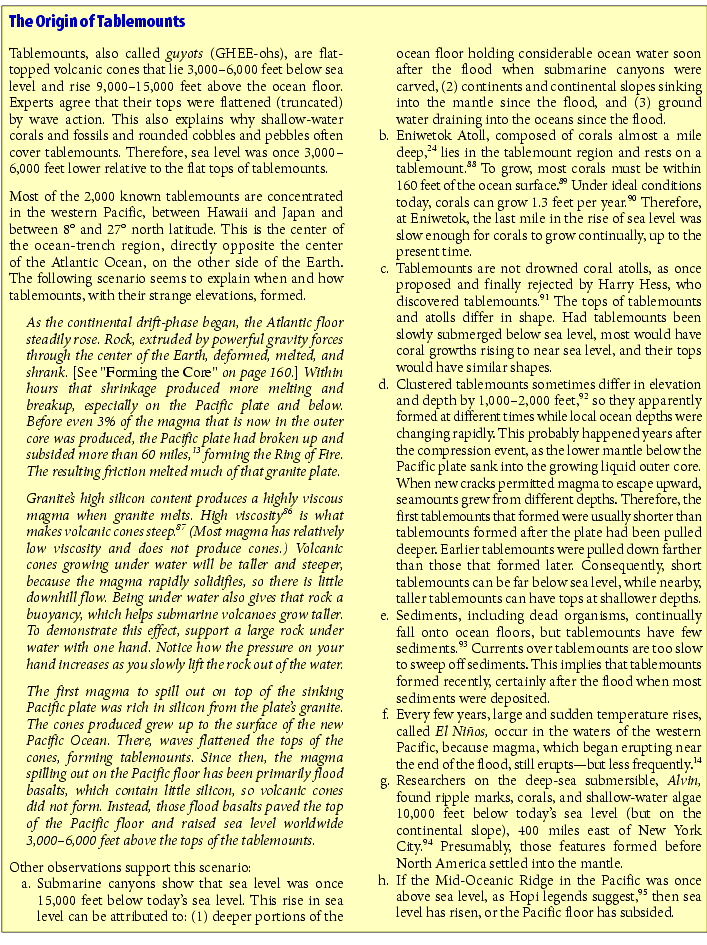
Continental Material under Ocean Floor. Some granitic, or continental, rock is found under the floors of the western Pacific and southern Indian Oceans.51
19.
HP: Basalt, not granite, lies below sediments that continually fall onto the floors of the Pacific and Indian Oceans. The basalt, recovered by deep-sea drilling, is not oceanic crust, but once flowed as a liquid up onto the ocean floor.86 What remains of the 50-mile-thick granite crust after it broke up (and partially melted) must lie a few miles under the lava coating the western Pacific floor. This has not yet been verified, because drilling into the Pacific and Indian Ocean floors seldom exceeds a mile in depth.87 Current drilling, typically only 0.11165 mile deep, penetrates primarily ooze and other sediments that have settled onto the ocean floor in the last several thousand years. Nevertheless, some continental material has been discovered, to the surprise of most geologists.51
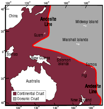
Figure 11: Andesite Line. This sharp discontinuity (shown in red) in the western Pacific was identified in 1912 by the famous New Zealand geologist, Patrick Marshall. The andesite line is considered “the most significant regional geologic distinction in the Pacific Ocean Basin,” 98 although the term andesite line has fallen into disuse among plate-tectonic advocates.
Volcanic islands east of the andesite line are basaltic, while islands to the west are made of andesite, a rock named for its presence in the Andes Mountains. Andesite contains minerals, such as hornblende and biotite, that are in granite (continental rock) but not in basalt. Despite its significance, geologists have never explained why continental crust lies below the western Pacific.
Geologists refer to a line running down the west-central Pacific as the “andesite line.” It has this name because eruptive rocks west of it are primarily andesite, whereas rocks to the east are primarily basalt. Andesite contains minerals, such as hornblende and biotite, that are present in granite, but not in basalt. These minerals came from melted granite. The andesite line “has been viewed as the dividing line between oceanic and continental crusts.” 52, 53 [See Figure 11 on page 183.]

PREDICTION 10: Fragments of a 60-mile-thick granite layer (a hydroplate) will be found a few miles under the Pacific floor and inside the Ring of Fire.
20.
PT: Little granite has been found.
[Response: The presence of even a little granite under the ocean floor, especially near the Mid-Oceanic Ridge, contradicts the plate tectonic theory, which says the ocean floor forms from melted basalt rising at oceanic ridges. No one has been able to demonstrate that granite can form from a melt, although students are taught that granite is an igneous material—meaning “formed from a melt.” 99 See “Geothermal Heat” on page 123.]
Images of Earth’s Interior. Seismic tomography should be able to show if plates do or do not subduct.
21.
HP: Table 4 on page 188 gives 17 reasons plates have not subducted. Each reason is a strong case against plate tectonics, which requires subduction. [See also "Is This a Subducting Plate?" on page 190.]
22.
PT: Great efforts have been made, using seismic tomography, to discover cold, subducting plates inside the mantle, specifically along Benioff zones. The results are ambiguous.
[Response: No three-dimensional subducting plate has been clearly identified. Sometimes, scientific journals will identify a two-dimensional linear feature beneath a trench, not a three-dimensional plate. However, each linear feature could be a fault, and, similar linear features are also found far from trenches.]
Fast Seismic Waves. The upper mantle is denser beneath continents than beneath oceans.9
23.
HP: After the continental-drift phase, the crushed, thickened, buckled, and sediment-laden continents slowly settled into the mantle, compressing the mantle more than normal. Consequently, seismic waves travel faster under continents.
24.
PT: Mantle properties under continents do not vary by much.
[Response: Why should seismic waves travel faster under continents if the mantle has been circulating and mixing for hundreds of millions of years? Mantle properties should be uniform.]
Fossils in Trenches. Fossils of shallow-water plants are found in trenches. How did they get there?
25.
HP: Fossilization requires special conditions. It should be no surprise that the global flood, which fossilized trillions of animals worldwide, also formed fossils in places that later became ocean trenches. Rapid burial, necessary to form and preserve fossils, was quickly followed by the subsidence of the Pacific plate and the downward buckling that formed trenches.
PREDICTION 11: Fossils of land animals, not just shallow-water plant fossils, will be found in and near trenches.
Figure 12: Global Shifts. Each arrow shows the average direction and speed of several years’ worth of shifting at one of about 150 locations worldwide. All measurements were made using the Global Positioning System (GPS), the most accurate of several methods for measuring these movements.
Notice that the arrows point in different directions, although most are toward the Pacific. This shows that material deep in the Earth shifts in various directions, but generally toward the Pacific. If the entire mantle were circulating, greater uniformity would be seen in speed and direction. The plate tectonic theory considers the plates, outlined in blue, as rigid, but the variations in the measured movements show that the plates are not rigid.101 For plates to move, pressure differences must exist. Either the pressure around the Pacific is greater than normal or the pressure under the Pacific is less than normal—or both. The hydroplate theory explains why both are true.
26.
PT: More research and sampling are needed.
[Response: Because plants float and quickly disintegrate, they should not be buried and preserved in one of the deepest parts of the Pacific Ocean.]
Deep Earthquakes. How can earthquakes occur 250–410 miles below the Earth’s surface where (a) pressures are so high that space cannot open up to allow movement, and (b) temperatures are so hot that rock does not break, but slowly and quietly deforms or flows?
27.
HP: See Figures 8 and 9 on page 169.
28.
PT: At certain high pressures and temperatures, the common mineral olivine undergoes a phase transformation that suddenly shrinks the mineral by 10–20%. Such implosions could produce large, deep earthquakes.
[Response: Yes, those phase transformations have been demonstrated in the laboratory, but they occur at pressures corresponding to depths in the Earth of 1,100 kilometers (680 miles).100 Deep earthquakes do not occur below 410 miles.]
Earthquakes Far from Plate Boundaries. Some earthquake epicenters are far from plate boundaries.
29.
HP: The compression event and Earth’s vertical adjustments during and after the flood produced thousands of faults throughout the mantle and crust. The weakest faults slip most frequently and are considered “plate boundaries,” but occasionally other faults slip and produce earthquakes far from plate boundaries.
30.
PT: Most earthquakes occur at plate boundaries. Although quite powerful, the New Madrid, Missouri (1811, 1812) and Charleston, South Carolina (1886) earthquakes—internal to plates—were exceptions.
Earthquakes Correlate with Low Tides. Many small earthquakes under the Pacific floor occur at low tide.14
31.
HP: Under the Pacific, this mantle flow is naturally greatest at points and times of relatively low pressure—which occur at low tides.
32.
PT: Earthquakes that occur under the Pacific floor are very weak.
Earthquake Driving Mechanism. What provides the energy and forces that cause earthquakes?
33.
HP: The flood produced huge mass imbalances on Earth. Gravity, acting on those imbalances, accelerated the water-lubricated hydroplates downhill. All this movement resulted in many faults that now pass through the entire mantle, as explained on pages 166–167.
The slightest movements along those faults generate frictional heat and melting. Mantle rock that melts above the crossover depth (about 220 miles below the Earth’s surface) expands slightly and attempts to escape buoyantly upward to the surface of the Earth, producing volcanoes and flood basalts. Magma produced below the crossover depth increases in density, so it slowly drains downward along those faults, into the outer core. These movements produce earthquakes, especially along the major faults that formed trenches.
34.
PT: Radioactive heating deep in the Earth sets up circulating cells within the mantle which drives crustal plates over the surface of the Earth. The leading edges of those plates are sometimes forced down into the mantle—a process called subduction—that forms trenches. Earthquakes occur when plates get stuck and suddenly break loose.
[Response: There is no evidence that radioactive material is in the mantle. The deepest magma and rocks ejected from volcanoes do not contain radioactive material. Furthermore, it has been known for almost a century that radioactivity is concentrated in the Earth’s crust. See “Where Is Earth’s Radioactivity” beginning on page 395.
Even if the mantle were circulating like a liquid, viscous drag acting on the bottom of a plate would apply only a constant force, just as a flowing river applies a constant force on an anchored boat. So, whatever force drives earthquakes must increase with time, because nearby rock stretches weeks and months before an earthquake, much as a rubber band stretches before it snaps.
Is the mantle circulating or shifting? If it is circulating, as the plate tectonic theory claims, some unknown energy source must drive the circulation. Adding energy, such as heat, to the mantle would not make the Earth more compact, as happens during all large earthquakes.8, 55 Besides, billions of years of movement should make the Earth about as compact as it could become.
However, shifting, driven by gravity, would make the Earth increasingly more compact and round. If the Earth’s mass became unbalanced during a global flood only about 5,000 years ago, shifts might still occur. Indeed, the global positioning system (involving at least 24 Earth-orbiting satellites that can measure crustal movements with millimeter precision) shows that in Asia and perhaps elsewhere, gravity drives crustal movements generally toward the Pacific.102 See Figure 12.]
Plate Reversals. What explains slow earthquakes, and why do they sometimes reverse directions? [See Figure 13.] Why are slow earthquakes often periodic and why do they frequently precede large earthquakes.103
35.
HP: See "The Core Below" on page 195.
36.
PT: There is an obvious problem with the push, pull, or drag mechanisms; neither push, pull, nor drag can explain why slow-slip earthquakes (described on page 164) reverse direction. This “remains a mystery.”17
Earthquakes Drop Local Gravity. The local gravity suddenly dropped after the large Sumatran earthquake in 2004.12
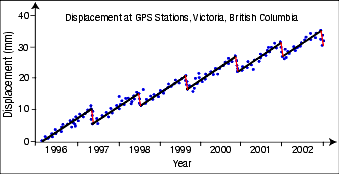
Figure 13: Plate Reversals. The Global Positioning System (GPS) is now so accurate that slow, millimeter-scale movements by crustal plates can be measured. What could cause plates to reverse direction, as shown by the red lines? 17 Why, for example, would a circulating mantle suddenly start circulating in the opposite direction, or why would a subducting plate that is supposedly becoming denser and diving into the mantle suddenly defy gravity and reverse direction? Also, why are the reversal speeds so much faster than “forward” speeds (as shown by the steeper slopes on the red lines)? Similar reversals occur at other locations on Earth. (All measurements were made relative to a point on the North American Plate.)
37.
HP: Sliding friction along the fault before, during, and after the earthquake melted rock. The melt below the crossover depth then drained down the fault and into Earth’s outer core, reducing the gravity as measured at the epicenter. Earth’s rotational moment of inertia also dropped, which shortened the length of the day.
38.
PT: One side of the fault suddenly lifted during the earthquake and produced a tsunami. That in itself increased the local gravity at the earthquake’s epicenter. Therefore, there must have been a sudden drop in the density (a dilation) on the opposite side of the fault.12
[Response: Both the uplifting of one side of the fault (which did occur) and the proposed dilation would have increased Earth’s rotational moment of inertia and increased the length of the day. However, the Sumatran earthquake suddenly shortened the length of the day by at least 3 microseconds. Melted rock that drains into the outer core following the earthquake would shorten the length of the day and reduce gravity at the epicenter.]
Tension Failures. Earthquakes near trenches are primarily due to horizontal tension perpendicular to the trench axis.13
39.
HP: Trenches are formed by long, deep faults, not by subduction. Millions of other faults exist, especially on and under the Pacific floor. Movement and friction have melted rock along those faults, lining them with magma. Magma below the crossover depth drains into the outer core and expands the outer core slightly. This, in turn, stretches the fractured mantle horizontally. Magma rising above the crossover depth spreads the walls of the fault and produces tension failures—earthquakes—perpendicular to a trench axis.
40.
PT: If plates converge, so that one plate is forced under the other, earthquakes near trenches should be compression failures.

Figure 14: Pressure Differences. Only huge pressure differences cause thick, viscous material to flow. Toothpaste, squeezed from a tube, flows out the opening at a velocity that depends not on how great the pressure is, but on the difference between the pressure at the squeeze point and the pressure at the opening. Therefore, squeezing toothpaste inside the sunken Titanic, where pressures are uniformly high, or on the Moon, where pressures are low, would be no harder or easier than at your bathroom sink. Because rock is so stiff, or viscous, it flows only under extreme pressure differences, such as existed under the floor of the widening Atlantic. Tiny pressure differences, claimed by plate tectonics, can do little to overcome the strength of crystalline rock, even over billions of years.
Wide Earthquakes. Some earthquakes beneath trenches rupture regions much broader than the thickness of any hypothetical subducting plate.104
41.
HP: Mantle material shifts over very broad areas, especially in the western Pacific, so some earthquakes should rupture broad regions.
42.
PT: Some earthquakes may trigger nearly simultaneous earthquakes nearby.
[Response: If so, seismographs should be able to identify two earthquakes.]

Figure 15: Deforming a Sphere Inward. When the hard outer shell of a ping-pong ball is depressed on one side, it deforms in an arc-and-cusp pattern. Materials always deform in a way that minimizes the energy required.
Earth’s crust is also a hard spherical shell, so it too will deform in an arc-and-cusp pattern if the crust is pulled down. Because many trenches under the western Pacific Ocean have arc-and-cusp shapes, they probably formed by subsidence of the western Pacific floor, not by subduction.
Reasonable Driving Mechanism. Forces should exist to form trenches.
43.
HP: After the flood phase, extremely large, unbalanced forces quickly lifted the lightly-loaded portion of the chamber floor that then became the Atlantic floor. Once movement began, frictional heating and gravitational settling produced magma, which immediately contracted far below the Pacific plate. Subsidence, faulting, and horizontal compression, especially in the western Pacific, formed trenches. Gravity produced all movements and forces.
44.
PT: In a liquid, small forces can produce small movements, which conceivably could become large movements if millions of years were available.
[Response: Large, unbalanced forces are needed for crystalline rock to “flow.” Plate tectonics does not explain such forces. Assuming that the solid mantle circulates like a liquid, simplifies the mathematics but unrealistically removes the need for large unbalanced forces.
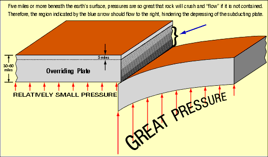
Figure 16: Subducting Plate. Pressure inside the Earth increases with depth. If one tried to depress a plate 30 miles or more below another plate, the growing upward pressure from below would quickly stop that depression long before 30 miles of depth was reached. So, subduction—necessary for plate tectonics—could not begin, even if the plate were colder and, therefore, denser, and even if rock stresses, including friction, were zero.
The technical note on page 608 explains why no continental cliff can be more than 5 miles high. Can you see from this figure why subduction violates that rule?
Because heat circulates water simmering in a pan, we cannot presume that heat circulates deep rock. The analogy breaks down, because temperature variations on the water’s surface change its surface tension which, is what circulates the water in the pan.105 Rocks do not have a corresponding force. Also, rock’s viscosity 88 is 23 orders of magnitude greater than that of water ! So, heat irregularities deep in the mantle are not large enough to circulate the mantle at the required velocities.
If the mantle circulates, adjacent cells must circulate in opposite directions, just as two simple interlocking gears must rotate in opposite directions. Cells circulating in opposite directions under a large plate would tend to cancel each other’s ability to move the plate, so a large plate would retard plate movements. (Worse yet, subducting plates would obstruct mantle circulation.)
Could one cell circulate under each plate? A large plate, such as the Pacific plate, would need to have a much larger cell width than a plate one-thousandth as large. However, the circulating (or convection) cells we see, such as within the atmosphere or a pan of simmering water, have height-to-width ratios of nearly 1:1, not 1:10 (for large plates) or 100:1(for small plates), as plate tectonics requires.
Tectonic plates, as hypothesized, vary in thickness. For example, a plate might be 60-miles thick under mountains but only 30-miles thick under oceans. Therefore, dragging a plate with a mountain “on board” would encounter great resistance. If we tried to slide one heavy washboard (or corrugated board) over another, their parallel ridges would interlock and resist movement. Also, if one plate stopped, the resulting “log jam” would stop all plates.]
Displaced Material. Large volumes of rock must have been removed to form trenches. Where did it go?
45.
HP: The rock removed to form trenches shifted toward the rising Atlantic floor. Also, rock melting below the crossover depth contracts and drains into the outer core.
46.
PT: We don’t know; more research is needed.
[Response: Geophysicists have often asked, “Where did that material go?” Plate tectonics has given no answer. A subducting plate, or anything pushed into the mantle, would add, not remove, material under a trench.]
Frictional Resistance. To form trenches and move so much rock, great frictional resistance must be overcome.
47.
HP: A block placed on an inclined plane will slide downhill if the gravity-related force exceeds the frictional resistance. Likewise, a big pit will be filled in if gravity forces can overcome the frictional resistance and strength of the walls and floor. The deeper and wider the pit, the greater the forces its walls and floor must resist. As with the sliding block, once movement begins, friction decreases, so movement speeds up. Also, the increasing momentum acts to maintain movement. If rock deep inside the Earth breaks and slides ever so slightly, friction will melt the sliding surfaces. The magma produced then acts as a lubricant, speeding movement even more.
During the early days of the flood, upward-jetting water removed rubble from the rupture’s crumbling, unsupportable walls, so the pit continually widened. Eventually, the floor was so wide it buckled upward, so the hydroplates slid downhill and widened the big pit even more. With less and less weight on the widening floor, it had to rise, and a corresponding depression had to occur over a broader region on the opposite side of the Earth. Today, gravity continually tries to squeeze the Earth back toward a spherical shape.
| Why Plates Cannot and Have Not Subducted |
See Pages |
|---|---|
| 1. A subducting plate would experience too much resistance in diving down through just the top of the mantle. The blunt front end alone would stop movement. Also, the unspecified force needed to overcome these resistances would (if a pushing force) crush the plate or (if a pulling force) pull the plate apart. |
|
| 2. Sediments, volcanoes, and plateaus have not been scraped off “subducting” plates in trenches. |
|
| 3. Sedimentary layers in trenches are undisturbed. These layers would be mangled if plates subducted. |
|
| 4. No known forces are available to break the crust into plates and separate those plates from their bases. |
|
| 5. One plate cannot even begin its dive under an adjacent plate that is 30–60-miles thick, because, as Figure 16 on page 187 shows, long cliffs would be 30–60 miles high—an impossible condition.29 |
|
| 6. Subduction cannot occur along an arc. Subduction is geometrically possible only along a straight line. (The arc-and-cusp pattern of ocean trenches shows subsidence, not subduction.) |
|
| 7. If subducting plates produce volcanoes, 100% of the volcanoes should be on the landward side of trenches. Most are on the seaward side. |
|
| 8. Below trenches are mass deficiencies, not mass excesses as subduction would produce. |
|
| 9. Beneath trenches, earthquakes sometimes occur across a much broader region than the width of a plate. |
|
| 10. Seismic tomography has not shown unambiguous subducted plates in even two dimensions. If plates subducted, seismic tomography could convincingly and dramatically show them in three dimensions. |
|
| 11. Some Benioff zones are nearly horizontal. Subducting plates should always move on a downward slope. |
|
| 12. Thick, buoyant continents would prevent subduction. |
|
| 13. A subducting plate would not reverse direction. |
|
| 14. Trenches and ridges do not have corresponding lengths and locations as plate tectonic theory requires. For every square mile of crust that emerges from a ridge, a square mile of crust should disappear at a trench. |
|
| 15. At three locations on Earth, a trench (and, according to plate tectonics, a descending plate) intersects a ridge (where material is supposedly rising). Material cannot be going up and down at the same time. |
|
| 16. Ancient trenches have never been found. |
|
| 17. Deposits of methane hydrates lie on the deep ocean floor, short but uniform distances from the continents they are supposedly subducting under. If plates are subducting, that would not be the case. Those deposits would be at various distances, and some deposits would have been swept under their overriding continent. |
48.
PT: While the crust is hard and brittle, just below it (about 60 miles below Earth’s surface) lies the asthenosphere, a region that is soft and deformable.
[Response: Even if the asthenosphere contributed no friction to a subducting plate, the 60 miles of rock above would—enough to prevent subduction. Subduction couldn’t begin. See the technical note on page 609.]
Arcs and Cusps. Some trenches, such as the New Hebrides/South Hebrides Trenches, are “U-shaped” when seen from above or on a map. Other trenches have arcs and cusps. [See Figure 1 on page 161.] What caused those shapes?
49.
HP: Hold a paperback book horizontally, then bend half of it downward. It bends only on a straight line. Likewise, a thick crustal plate trying to subduct would only bend on a straight line. However, all trenches curve.
Now, visualize a growing partial vacuum inside a sealed metal can, as described on page 168. Its walls will buckle inward in a variety of curved shapes. Also, the floor of the western Pacific, as it was “sucked” down toward the rising Atlantic, buckled downward in many curved shapes, as seen from above or on a map. When a hard spherical shell (such as the Earth’s crust or even a ping-pong ball) buckles inward, the deformation pattern is usually one of arcs and cusps.
Just as the maximum depression on a ping-pong ball is deeper than the depression at any of its cusps (Figure 15), so the western Pacific was initially deeper than the trench cusps. As continents sank into the mantle in the centuries after the flood, the western Pacific floor rose.
50.
PT: Subducting plates must deform if they subduct along an arc. If they subduct along a concave arc, the plate will be stretched. Some experts claim to see evidence that tearing has occurred.
[Response: Other experts disagree. If tearing (tensile failure) occurs, what large force does that tearing? Then, what are the much larger horizontal forces required to crush a plate subducting along a convex arc, and is there any evidence that has occurred? (Saying that it must have occurred because subduction occurs is illogical.) Only if a plate could subduct along a straight line would these extreme stretching and compressing forces not be needed. Almost all trenches form an arc, not a straight line.]
Concentrated Trenches. What concentrated so many trenches in the western Pacific?
51.
HP: The continental-drift phase began when the subterranean floor became unstable and rose in what is now the Atlantic. This quickly lessened the tendency for the subterranean floor to become unstable and rise elsewhere. A corresponding depression had to occur on the opposite side of the Earth—the western Pacific.
52.
PT: It is probably a coincidence. There is no reason plates should prefer to subduct in the western Pacific.
[Response: Highly unlikely. Trench concentrations in the western Pacific are just too great. Besides, oceanic ridges exist in all oceans, so trenches should be equally dispersed. If rock rises at ridges and subducts at trenches, why is the total ridge length (46,000 miles) three times longer than the total trench length (about 15,000 miles)?]110 (Also, keep in mind that material supposedly exits ridges in two directions, which doubles the problem.)
Undistorted Layers in Trenches. Sedimentary layers in trenches are usually horizontal and undistorted.
53.
HP: Since the flood, sediments in trenches have settled gently onto a relatively stationary ocean floor.
If subduction occurs at trenches, the overriding plate should scrape off the layered sediments, volcanic cones, and oceanic plateaus riding on the subducting plate. Seismic reflection profiles show that trenches contain horizontal, undistorted layers with no sign of subduction. Nor are scraped-off volcanic cones collecting in trenches.
54.
PT: Yes, this is surprising. As H. W. Menard stated,
... it would seem that the sediment sliding into the bottom of the trench should be folded into pronounced ridges and valleys. Yet virtually undeformed sediments have been mapped in trenches by David William Scholl and his colleagues at the U.S. Naval Electronics Laboratory Center. Furthermore, the enormous quantity of deep-ocean sediment that has presumably been swept up to the margins of trenches cannot be detected on sub-bottom profiling records.111
Other authorities have made similar observations.112
Initiation. How does a trench start to form?
55.
HP: Trenches began to form as the Atlantic floor rose at the beginning of the rapid continental-drift phase. The western Pacific floor then subsided, producing horizontal compression, downward buckling, shearing (faulting), and trenches.
56.
PT: When two plates collide, the denser plate is pushed down, and subduction begins. Subduction produces trenches.
[Response: For subduction to begin, the Earth’s crust must first break—a herculean task for which experts on plate tectonics admit they have no “sound quantitative” explanation.
The initiation of subduction remains one of the unresolved challenges of plate tectonics.106
Next, for a broken plate to subduct, its entire edge, up to thousands of miles long, must be depressed at least 30 miles, the minimum thickness of these hypothetical plates. Nothing even approaching that large a topographic discontinuity has ever been seen anywhere on Earth. Figure 16 explains why this could never happen.
Table 4 give 17 reasons subduction has not occurred.]
“Fossil” (Ancient) Trenches. If trenches have been on Earth for hundreds of millions of years, many trenches should now be buried. Some should even have been lifted above sea level. Ancient trenches have never been found. As Fisher and Revelle noted:
Where are the trenches of yesteryear? Are we living in an exceptional geologic era; are the apparently young trenches of the present day unusual formations that have had no counterparts during most of geologic time? Such a speculation would be repugnant to many geologists, because it would be difficult to reconcile with the doctrine that the present is the key to the past. We must continue to search for ancient trenches—on the deep-sea floor, in the marginal shallow water areas and on the continents themselves.113 ]
57.
HP: Because the flood was a single, recent event, one should not expect to find ancient trenches.
58.
PT: Rocks, found at several continental locations, contain ocean floor minerals that have been compressed and deformed. They may have been scraped off a subducting plate in a trench.
[Response: That is only one interpretation. The leading edge of hydroplates would scrape up (as with the blade of a bulldozer) and deform similar sediments as they decelerated during the rapid continental-drift phase. As stated in the quotation by Menard on page 191, sediments that should be scraped off subducting plates and in trenches are not seen. If those rocks are from an ancient trench, what lifted them up?
Other. The following details pertain primarily to one theory or the other.
59.
HP: Earth’s extremely large magnetic field formed as a direct consequence of the events that produced ocean trenches. [See "The Origin of Earth’s Powerful Magnetic Field" on page 194.] This also explains why the crystals in the inner core are oriented in a preferred direction—toward the magnetic poles.32
The plate tectonic theory does not address the origin of the Earth’s magnetic field, although for decades schools and textbooks have taught that it is generated by a geodynamo operating in the Earth’s outer core. Most experts will admit that the geodynamo theory has many problems, and many experimental efforts have not been able to produce a realistic dynamo.114
60.
HP: Chekunov et al. described experiments involving fracturing in small-scale models and discussed temperature and strength variations in the crust and upper mantle. Based on these considerations, they concluded that trenches and Benioff zones imply subsidence, not subduction.115
61.
HP: Earth’s inner core spins faster than the rest of the Earth, a consequence of vertical shifts of mass within the Earth during the flood, gravitational settling, the formation of the liquid outer core, and the law of conservation of angular momentum. Even today, magma draining down from the mantle is adding angular momentum to the core. These same factors also explain why many historical records show that the Earth had a 360-day year before the flood.
62.
PT: Ridges and trenches do not always correspond to each other, as they should if plates form at ridges and move toward and disappear under trenches. According to plate tectonics, about as much land area should rise from ocean ridges per unit time as descends into trenches, but the total length of all ocean ridges is three times longer than that of all ocean trenches!110 Besides, material is supposedly rising out of in two opposite directions, which doubles the problem. Also, why are trenches primarily in the western Pacific Ocean, when ridges are more equally distributed over the entire Earth?
63.
PT: If, as plate tectonics maintains, material is rising from the mantle at ridges and diving into the mantle at trenches, a contradiction occurs where a ridge and trench intersect.116 This happens at three locations in the eastern Pacific: 50.5°N latitude and 130°W longitude, 20.5°N latitude and 107°W longitude, and 46.3°S latitude and 75.7°W longitude. The same—or even closely spaced—mantle material cannot be going both up and down at the same time.
64.
PT: A linear pattern of earthquakes intersecting a trench defines a Benioff zone. Most Benioff zones are steeply inclined, but one under a long portion of the west coast of South America is nearly horizontal.117 If these earthquakes occur along the surface of a subducting plate, no portion of the Benioff zone should be nearly horizontal, because the plate is supposedly diving through the mantle. However, consistent with the hydroplate theory, these earthquakes could originate on a nearly horizontal fault.
65.
PT: Continents, being thick, buoyant, and strong, should prevent subduction. As Molnar admitted:
... the buoyancy of thick continental crust keeps it afloat. If continental lithosphere were strong enough to maintain its integrity at a subduction zone, the buoyant continental crust would not only resist being subducted, but the subducting plate would abruptly grind to a halt when the continental “passenger” reached the trench.118
Molnar, who believes that oceanic crust subducts, must then conclude that continental crust must not be strong enough to resist subduction. He has not shown that to be true, nor has he shown that the Earth is littered with continents torn apart as they descended into trenches. Instead, he admits that “finding a simple and accurate way to represent the deformation of continents remains a major task.” 119 If plate tectonics has been going on for a billion years, why aren’t most continents wedged up (or crushed up) against trenches?