Liquefaction During the Compression Event
While liquefaction operated during the flood phase, it acted massively once during the compression event, at the end of the continental-drift phase. [See pages 118– 157.]
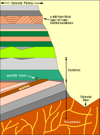
Figure 6: Grand Canyon Cross Section. The tipped and beveled layers are part of the Precambrian. The horizontal beveled plane, at the Cambrian-Precambrian interface, is sometimes called The Great Unconformity. A similar, but much smaller, example of tipped and beveled layers is shown in the cross-bedded sandstone in Figure 115. Beveling implies relative motion. Near the top of the Grand Canyon is a 400-foot-thick layer of cross-bedded sandstone. The white arrow points to the quartzite block shown in Figure 7.
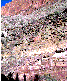
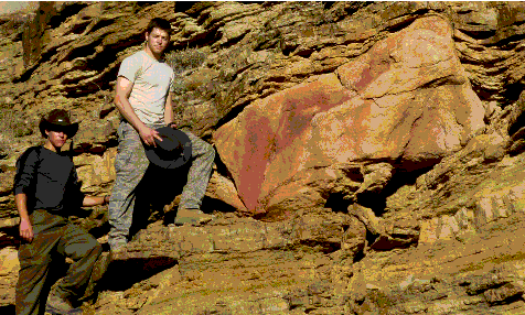
Figure 7: Transported Block in the Grand Canyon. In the left figure, notice the large, 5–10-ton block near the center, and the shadows of photographer Jim McDowell (my son-in-law) and two grandsons, Sean and Ryan McDowell. The right figure is an enlargement of the block with Ryan and Sean (left to right).
An article by geology professor Arthur V. Chadwick brought this block to my attention in 1978.28 Later, we got to know each other when he visited my office. The block—a very hard material called quartzite—was lifted, transported from right to left, and deposited on layers which, at the time, were soft mud. Other mud layers then blanketed the block. (See the deformed layers below and above the block.) Professor Chadwick correctly identified the lifting force: a very dense, rapidly-flowing, sand/mud/water slurry, which plucked the block off the lower quartzite layer upstream (far to the right of these pictures). Part of that “pink” quartzite layer is seen in the first picture (lower right). The easiest way to lift and transport such a heavy block is in a dense liquefied (and therefore, very buoyant), sediment/water mixture that is flowing at a high velocity.
This rapid transport, which was immediately above the Cambrian-Precambrian interface, occurred during the compression event. Below the sliding slurry, a sand layer decelerated and compressed first. That compression squeezed up water that lubricated the slide and heated the quartz sand, so it became quartzite.29 Compression also tipped the layers up, causing them to be beveled by the overriding, sliding layers. The camera is looking north; therefore, the slurry slid from east to west, which is consistent with the direction the Americas hydroplate slid away from the Mid-Atlantic Ridge. (Evolutionary geologists who do not understand the physics and the rapid continental drift that ended in the compression event, explain the flat Cambrian-Precambrian interface as a result of hundreds of millions of years of erosion. For them, unimaginable time explains everything. Lazy and sloppy thinking.)
See Figure 6 for a cross section of this region. The block is located at 36°7'34.80"N, 112°8'39.60"W. Hikers should not attempt to reach this remote, rugged, off-trail location unless they are in excellent physical condition and have permission from the Grand Canyon’s Backcountry Office.
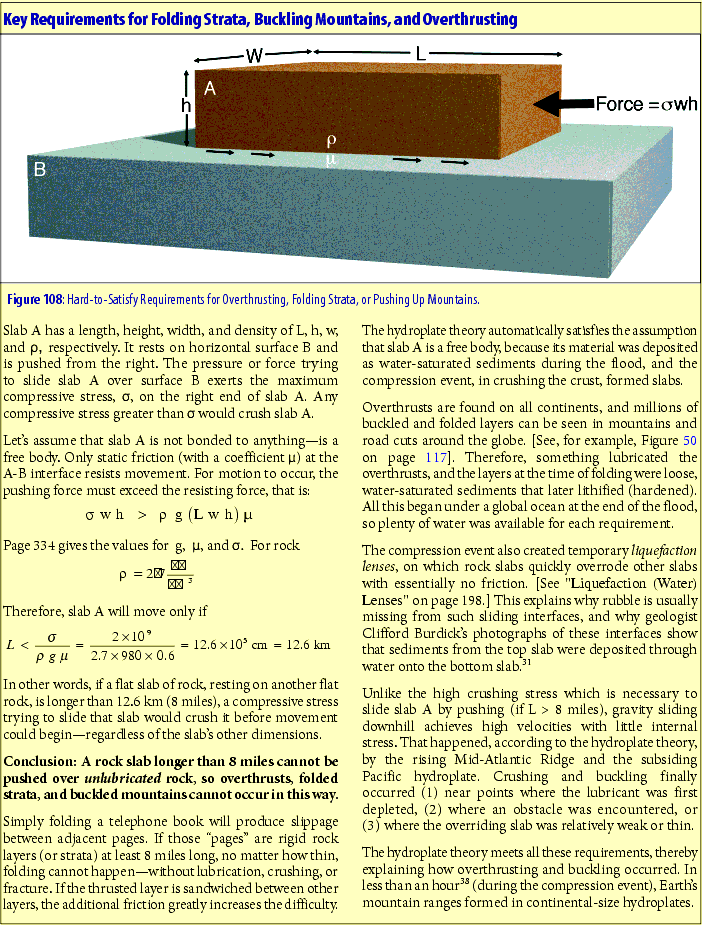
Visualize a deck of cards sliding across a table. Friction from the table slows the bottom card. That card, in turn, applies a decelerating force on the second card from the bottom. If no card slips, the entire deck, including the top card, will decelerate as a unit. But if a lubricant somehow built up between any two adjacent cards, cards above the lubricated layer would slide over the decelerating cards below.
Likewise, each decelerating granite hydroplate acted on the bottom sedimentary layer riding on the hydroplate. Sedimentary layers, from bottom to top, acted in turn to decelerate the topmost layers. As each water-saturated layer decelerated, it was severely compressed—similar to suddenly squeezing a wet sponge. Sediments, forced
|
|
||
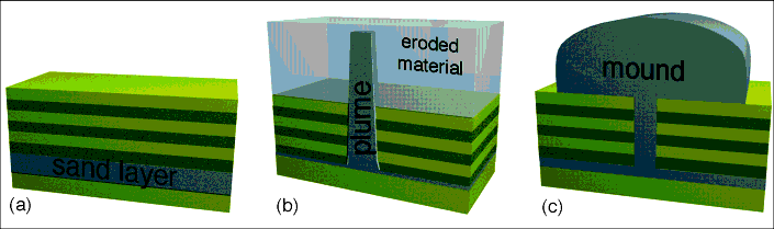
| Figure 110: Formation of Liquefaction Plumes and Mounds. (a) During the flood phase, global liquefaction sorted water-saturated sediments into nearly horizontal layers. (b) During the compression event, massive liquefaction caused less-dense sand/water mixtures to float up as plumes, through denser overlying layers. ( Figure 62 on page 134 shows a similar phenomenon.) Later, if surface layers were not cemented as well as the sandstone plume, the surface layers could erode away, leaving the harder, more-resistant plume exposed. (c) If a plume spilled out on the ground, a mound would form. |
||
|
|
|
|
|
|
|
|
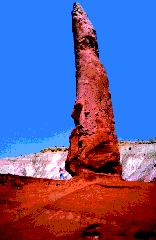
| Figure 111: Liquefaction Plume 1. A hundred of these plumes are found in Kodachrome Basin State Reserve in south-central Utah, 10 miles east of Bryce Canyon National Park. I am standing at the bottom left of this tall plume. |
|
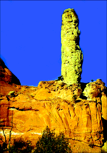
Figure 112: Liquefaction Plume 2. This plume can be traced down several hundred feet through the large rock in the bottom half of the picture. The plume rose from a specific horizontal sandstone layer that has identical chemical characteristics.40 After the plume pushed upward, cementing occurred, with the sandstone plume becoming harder than the material it penetrated. Softer layers surrounding the plume later eroded away, leaving the plume exposed. [See Figure 110b.] Notice the person waving at the bottom left of this plume. |
into a denser packing arrangement, released water. Sedimentary particles were crushed or broken, so their fragments filled the spaces between particles, releasing even more water. The freed water, then forced up through the sediments, caused massive liquefaction. As the sedimentary layers decelerated and compressed, they became more and more fluid. Eventually, some layers were so fluid that slippage occurred above them, as in our deck of cards. Below that level, extreme compression and liquefaction caused fossils to float up and collect at this watery level where sliding was taking place.
A major slippage surface is now called the Cambrian-Precambrian boundary. Fossils are found almost exclusively above this interface. Therefore, evolutionists interpret the Precambrian as about 90% of all geologic time—a vast period, they believe, before life evolved. A few feet above this global interface are found representatives of all animal and plant phyla. [See “The Cambrian Explosion” on page 13.] This presents a huge problem for evolutionists: How and why did so much life evolve so fast—a phenomenon evolutionists call “the Cambrian explosion”? 30 Again, evolutionists are unaware of global and massive liquefaction and mistakenly measure time by sedimentary layers and their fossils.
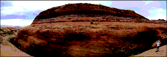
Figure 113: Liquefaction Mound.41 This and hundreds of similar sandstone mounds occupy the basin of the former Grand Lake. The breaching of Grand Lake carved the Grand Canyon. [See pages 215– 257.]
The compression event produced massive liquefaction in water-saturated sand layers. During the few minutes the liquefaction lasted, some sand-water mixtures erupted, much like a volcano. Here, the eruption was onto the floor of Grand Lake. The large, mushy pile of sand quickly settled into the shape of an upside-down bowl. As the flood waters drained off the continents, this large, wet sand pile was protected, because it was deep in a lake. As the warm lake cooled, silica dissolved in the water was forced out of solution, thereby cementing the mound’s sand grains. A century or so later, when Grand Lake spilled out, rushing water around the mound eroded the softer sediments on which the mound rested, producing the deep “moat” that separates the man at the lower right from the mound.
In the Grand Canyon, the Cambrian-Precambrian interface is an almost flat, horizontal surface exposed for 66 miles above the Colorado River. Layers above the Cambrian-Precambrian interface are generally horizontal, but layers below are tipped at large angles, and their tipped edges are beveled off horizontally. [See Figure 6.] As slippage began during the compression event, layers below the slippage plane continued to compress to the point where they tipped. The sliding sedimentary block above the slippage plane beveled off the still soft tops of the tipped layers.
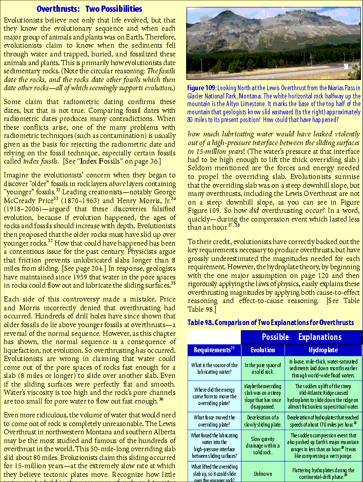
Evolutionists have a different interpretation. They believe tipped Precambrian layers are remnants of a former mountain range, because mountains today often have steeply tipped layers. [See Figure 50 on page 120.] The tipped layers are horizontally beveled, so evolutionists say the top of the mountain must have eroded away. That, of course, would take a long time. Millions of years are also needed so seas could flood the area, because fossils of sea-bottom life are found just above the Cambrian-Precambrian interface. Within overlying layers, other fossils are found which required different environments, such as deserts or lagoons, so obviously, even more time is needed. (Unlimited time makes the nearly impossible seem possible—if you don’t think too much about mechanisms.)
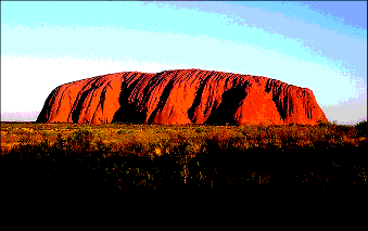
Figure 114: Ayers Rock. This popular tourist attraction in central Australia is 225 miles southwest of Alice Springs. Ayers Rock rises 1,140 feet from the desert floor and has a perimeter of 5.6 miles. Geologists who try to explain the origin of Ayers Rock say its sand came from the Musgrave mountain range 60 miles to the north and was dumped by water at its present spot. To account for its vertical layers, they say the rock “tipped,” but the forces, energy, and mechanisms to do this are never explained. However, most geologists admit they do not know the origin of Ayers Rock.
Ayers Rock has characteristics of both a broad liquefaction plume and a liquefaction mound. [See Figure 110.] Its surface layers (bedding) are nearly vertical, and they connect to a horizontal sandstone layer underground. It formed in the Amadeus Basin, whose contained waters covered and protected it while the flood waters drained from the Earth. Probably most soft sediments, through which the plume rose, were swept away when the basin’s lake finally discharged. The many large holes in the sides of Ayers Rock show where water drained out. (Almost 20 miles away, this same, deep horizontal sandstone layer also connects to a series of liquefaction eruptions called the Olgas.)
The sand grains comprising Ayers Rock are jagged but, if exposed to rapid currents, would have become rounded. Had the grains been weathered for thousands of years, they would have become clay. Instead, these grain characteristics are consistent with the gentle currents produced by liquefaction and the rapid cementing in the years after the flood.
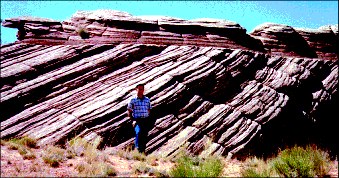
Figure 115: Cross-Bedded Sandstone. Dry sand can have a maximum slope of only 32 degrees. Cross-bedded sandstone, such as shown here, often has greater slopes. Therefore, this sand was probably wet when the layers tipped.
Notice that the top (nearly horizontal) layers obviously slid over and beveled the tops of the tipped layers below. Something, such as water was needed to lubricate the sliding, otherwise the horizontal layers would be wrinkled or crushed. But what was the lubricant, and what was its source? What confined the lubricant between the sliding surfaces? What tipped the lower layers, and what pushed the top, horizontal layers over the tipped layers?
As the compression event began near the end of the flood, these sediments—all horizontally layered by liquefaction during the flood phase of the preceding months—were riding on decelerating hydroplates. The deceleration rapidly compressed the water-saturated sand, just as your hands might horizontally compress a wet sponge. Water squeezed out of the wet sand formed a temporary liquefaction lens that decoupled the sliding layers above from the layers below that were being simultaneously tipped by the horizontal compression. The compression event was over in minutes.
Also notice that the tipped layers are slightly concave upward. Over long distances, this concave-upward pattern is often seen throughout the world’s sedimentary layers. It occurs because a layer pushed horizontally (even if lubricated) would collide with what it is being pushed into. However, the more the layer is tipped upward, the less the resistance and the greater the thickening. Thus, these compressed and sheared layers are concave upward—increasingly tipped upward along their length and in the direction of their movement. The Appalachian Mountains are one of the most dramatic examples of this.
Cross-Bedded Sandstone. Sand layers had the greatest water content, because sand grains are somewhat rounded, leaving relatively large gaps for water between the particles. Therefore, sand layers were the most fluid during the massive liquefaction that accompanied the compression event. Deceleration forced the sand forward, displacing the water backward. Horizontally compressed sand layers would have slid, tipped, buckled, and beveled individual layers and blocks of layers, exactly what we see in cross-bedded sandstone. [See Figure 115.]
Liquefaction Plumes and Mounds. The large water content of liquefied sand layers (40%) would have made them quite buoyant. Whenever a low-density, fluid layer (such as a water-sand mixture) underlies a denser, liquefied layer, the lighter fluid, if shaken, will float up in plumes through the denser fluid. Sand plumes that penetrated overlying layers are seen in many places on Earth. [See Figures 110–112.]
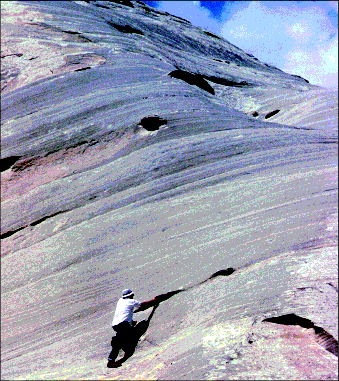
Figure 116: Medium-Sized Water Vents. Geology professor Dr. Douglas A. Block points to one of many holes in the side of a huge liquefaction mound in southern Utah. If these holes were places where rock was weakly cemented, similar holes should be on the tops of mounds. Instead, the tops are smooth. Cementing in mounds and cross-bedded sandstone is remarkably uniform and hard, showing that the cement was uniformly dissolved throughout water that saturated the sand.
Figure 117: Small Water Vents. These water vents are smaller than a pebble; others, such as those in Ayers Rock, are larger than a car. Water vents are quite different from the shallow and smooth bowl-like depressions which wind and rain erosion produced.
Some plumes, especially those rising from thick, laterally extensive sand layers, spilled onto the Earth’s surface. This spilling-out resembled volcanic action, except water-saturated sand erupted, not lava. Small liquefaction mounds, as they will be called, appear when liquefaction occurs during earthquakes.42 [See Levin’s description on page 205.] Hundreds of liquefaction mounds are found in basins—former postflood lakes—in the southwestern United States.
Why basins? During the compression event, liquefied water-sand mixtures in many places erupted up onto lake bottoms. Being surrounded and permeated by water, they would have quickly slumped into the shape of an upside-down bowl—a liquefaction mound. As the flood waters drained at the end of the flood, most liquefaction mounds were swept away, because they did not have time to be cemented. However, mounds inside postflood lakes (basins) were cemented as each lake cooled and its dissolved silica and calcium carbonate were forced out of solution. If a lake later breached and dumped its water, the larger cemented mounds could resist the torrent of rushing water and retain their shapes. The basins that held Grand and Hopi Lakes, shown on page 214, contain hundreds of mounds, such as the one in Figure 113. The sudden breaching of those lakes several centuries after the flood carved the Grand Canyon. [See pages 224– 262.]
Liquefaction mounds have holes in their sides showing where internal water escaped. The channels have collapsed except near the mound’s surface where there was much less collapsing stress. Those holes now look like pock marks. Some have claimed they are erosion features from wind and rain. Obviously, wind and rain would smooth out pock marks, not make them. Besides, these “pock marks,” which will be called water vents, are found only
in the sides of mounds, not the tops, where they should be if outside erosion formed them.
For centuries after the flood, water drained out of mountains and cliffs. Caves were carved by outward flowing water. New inhabitants to an area sought out and settled around these plentiful sources of water. (Thus, many ancient cultures believed that water originated in mountains and flowed out of caves.)46 Years later, as water sources dwindled, communities were forced to leave. Prosperous cultures, such as the Anasazi and cliff-dwellers, suddenly disappeared from an area, causing anthropologists to wonder if disease, war, famine, or drought destroyed those ancient communities. No; their water simply dried up.