| See Bryan Nickel’s excellent, partially animated summary of this chapter at: https://www.youtube.com/watch?v=DZ4eVMd3_PE&feature=youtu.be |
The Origin of the Grand Canyon
SUMMARY: Geologists now admit that they do not know how the Grand Canyon formed, but for the last 140 years, they have insisted that the Colorado River carved the canyon over millions of years and somehow removed the evidence.2 ( Figure 43 on page 110 describes two obvious problems with that idea.) However, some so-called experts admit that the canyon’s birth remains a “hazy mystery, cloaked in intrigue, and filled with enigmatic puzzles.” 3 After studying those puzzles, we will examine the eight main explanations for the Grand Canyon’s origin and see why almost all experts reject them. Finally, we will consider two former postflood lakes—Grand Lake and Hopi (HO-pee) Lake—that several centuries after the flood, breached their boundaries and carved the Grand Canyon in weeks. This explanation not only unravels the confusion but solves other major puzzles not previously associated with the Grand Canyon. For a quick explanation, see Figure 123 on page 220.
The Grand Canyon is the best and most famous earth-science laboratory in the world. Although a few canyons are deeper or longer or steeper or wider, only the Grand Canyon excels in all these categories. No other canyon on Earth can compare with the Grand Canyon’s scenic variety, massiveness, beauty, and three-dimensional exposure. It is 216 miles long,4 4–18 miles wide, and about 1 mile deep. Writers correctly describe the canyon in such lofty terms as magnificent, majestic, stupendous, inspirational, breath-taking, awesome, “the most sublime and awe-inspiring spectacle in the world,” and “Earth’s greatest natural wonder.” The first reaction of most of the 6 million annual visitors to the canyon is stunned silence.
Probably the foremost questions visitors have is, “How did this happen? What formed the Grand Canyon?” Bruce Babbitt, former Governor of Arizona (1978–1987) and U.S. Secretary of the Interior (1993–2001), relates the answer given by John Hance. In 1883, Hance became the first white settler in the Grand Canyon. He was one of the canyon’s most colorful personalities, tour guides, and explorers.
Children loved John Hance, and to them, he always explained how the canyon came into being. “I dug it,” he would say simply. This story worked well for years until one little four-year-old girl asked seriously, “And where did you put the dirt?” Hance had no ready answer; he never used that story again. But it bothered him the rest of his life, and when he was dying, he whispered to his waiting friends, “Where do you suppose I could have put that dirt?” 5
That question still haunts geologists, because if the Colorado River carved the canyon, as commonly assumed, that dirt would have formed a gigantic river delta where the Colorado River enters the Gulf of California. Instead, the delta is tiny—certainly compared to the vast volume of sediments removed to form the canyon.
Colorado River. Actually, the puzzle is much more difficult. Geologists now agree that the Colorado River began flowing out of the western Grand Canyon only recently. Here’s why. Before the Glen Canyon Dam was built upstream from the Grand Canyon in 1963, the gritty Colorado River carried an average of 550,000 tons of sediment (sand, silt, and clay) out of the canyon each day—more than 5 tons each second! 6 West of the Grand Canyon, the Colorado River cuts through a 650-foot-thick layer of Hualapai (WALL-uh-pie) Limestone whose topmost layers have been dated, using radiometric techniques, as less than 5,900,000 years old.7 If the river flowed through a lake that supposedly deposited this almost pure limestone, why are common river sediments not found in that limestone? 8
Obviously, all that limestone was there before the river arrived—in geologic terms, recently. How recently? According to most geologists, it was within the last one-thousandth of the Earth’s history! 9
Three different types of similar, water-transported rocks are on opposite sides of the western Grand Canyon—rocks that could not have been transported from one side to the other if the canyon blocked the way.10 Therefore, those rocks were present before the Grand Canyon formed, and the Colorado River began flowing out of the western end of the Canyon. Since 1934, geologists have been trying unsuccessfully to find a previous location for the river or to learn why the river began so recently.11
Kaibab (KI-bab) Plateau. A quick look at a relief map raises another question. Why and how did the mighty Colorado River, flowing southward into northern Arizona along the east side of the Kaibab Plateau, suddenly make a right turn and flow west, up and over (or through) the high Kaibab Plateau? Rivers don’t flow uphill! Desert View, an overlook on the Kaibab Plateau just south of the Colorado River, rises 5,800 feet above the river. Just across the river, the land rises even higher.
All attempts to explain the Grand Canyon try to answer this question.12 Some guess that the river was once a mile higher, and it flowed over and eroded a path down through the Kaibab Plateau—a process called superposition. Others say the river cut through the Kaibab Plateau along a fault (a crack). However, geologic maps do not show that fault, and almost all faults in the region are perpendicular to the Colorado River, not parallel. Some believe that the land under the river somehow rose, forming the Kaibab Plateau, and allowed a river to cut down through the rising plateau. Two theories say that a stream flowing westward, down a western slope of the Colorado Plateau, continually eroded eastward 130 miles and eventually cut through the Kaibab Plateau—a process called headward erosion. Notice how these untestable explanations require millions of years to verify and provide no physics-based mechanism. Think how many untestable (and therefore, unscientific) explanations we could fit into millions of years if those explanations didn’t have to conform to the laws of physics.
Missing Mesozoic Rock. Actually, cutting through the Kaibab Plateau is a relatively minor problem, and carving the entire Grand Canyon is not even half the problem. The Grand Canyon’s rim consists of hard Kaibab Limestone, typically 350 feet thick. When you walk to the canyon’s edge to look down, you are standing on Kaibab Limestone. It extends away from the canyon in all directions for about 10,000 square miles. However, rising 1,000 feet above this Kaibab Limestone at a few dozen isolated spots are softer (crumbly or weakly cemented) Mesozoic rocks, such as lava, which always lie on top of the crumbly rocks and prevent their erosion. Obviously, lava did not flow up to the top; lava, which flows downhill, collected in depressions and hardened. Later, a fast-moving sheet of water flowed over northern Arizona and swept all the soft Mesozoic rock off the hard Kaibab Limestone—except for those few dozen high spots which were capped and protected by hard rock.
Why was it a sheet of water? Falling rain would cut only channels. Flowing rivers or streams, even if they meandered for millions of years, would not uniformly sweep a 1,000-foot-thick layer of material off almost all of those 10,000 square miles of the fairly flat Kaibab Limestone. Besides, meandering rivers would produce meandering patterns. Therefore, before you can excavate 800 cubic miles of rock below the rim’s Kaibab Limestone to form the Grand Canyon, something must sweep off almost all the Mesozoic rock above—a much larger excavation project. Surprisingly, water also swept Mesozoic rock off the Kaibab Plateau. How could water get so high? As you will see, the sweeping event, called the Great Denudation, caused the Kaibab Plateau to bulge upward.
Marble Canyon. To form the Grand Canyon requires first forming Marble Canyon, which is directly upstream (northeast) of the Grand Canyon. The two canyons join where the Little Colorado River enters the Colorado River. John Wesley Powell, who led the first known expedition through these canyons in 1869, mistakenly thought the water-polished limestone he saw was marble, so he named the canyon Marble Canyon. Marble Canyon is straighter, narrower, shorter (61 miles long), and has steeper walls. The two canyons are like two adjoining pipes; any explanation for one pipe should also explain the other pipe, even if they have different shapes.
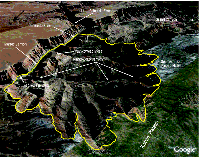
Figure 2: Nankoweap—Region of Unusual Erosion. This view is looking southeast from 38,000 feet above the ground. The Little Colorado River enters the southern end of Marble Canyon (at the top center). The yellow line encloses a region of unusual erosion. Notice that on top of the high Kaibab Plateau, streams do not flow into the many canyons that cut into this southeastern portion of the Kaibab Plateau. So, what cut these side canyons, and why are they in such a localized area? Why would the terrain east of Marble Canyon, which is at least 2,000 feet below the top of the Kaibab Plateau and most of this erosion, be so smooth? On top of Nankoweap Mesa are slumps, landslides, and rockfalls. How can rocks fall and mud flow onto the top of a mesa?
All the thin strata in and around Marble Canyon tip in directions that form a curious, but consistent, pattern. People floating southward inside Marble Canyon sense that they are rapidly falling. An optical illusion causes that sensation, because the strata inside the walls of Marble Canyon tip up to the south, so as one floats downstream, one rapidly moves past lower and lower layers in the narrow walls to the immediate left and right. Relative to a fixed point on the ground, one is only dropping about 8 feet each mile—a hardly perceptible rate.
If we look closely, we can see that the layers in Echo Cliffs (to the east) and Vermilion Cliffs (to the west) tip up toward Marble Canyon. At the southern end of these cliffs, the layers also tip up to the south, toward the Grand Canyon 30 miles away. [See Figure 9 on page 236.]
Later, you will see that the rapid removal of the dirt that formed Grand and Marble Canyons caused the surrounding regions to rise, just as removing one book from a stack of books resting on a spring scale will lift the remaining books.
Another unusual feature of these cliffs and others in the region is the lack of rubble, called talus, at the base of the cliffs. If freezing and thawing cycles acted for millions of years on the cliff faces, a sloping pile of loose rocks should be at the base of the cliffs. Even if the cliffs were young, lifting or carving cliffs should have left considerable talus.
Side Canyons. Dozens of vast side canyons intersect the main trunk of Grand and Marble Canyons and cut down to the level of the Colorado River. If it took the mighty Colorado River millions of years to carve the Grand Canyon, why do all these side canyons, with no visible source of water, also cut down to the Colorado River? These side canyons also have side canyons, all connected like branches on a big, bushy tree.
If these side canyons formed before the main trunk of Grand and Marble Canyons, most would extend to the opposite side of the main trunk. They don’t. If these side canyons formed after Grand Canyon and Marble Canyon formed, many would not cut down to the Colorado River, especially with no visible source of water to carve them. Therefore, these side canyons probably formed at the same time as Grand and Marble Canyons.
Some side canyons, called slot canyons, are much narrower than they are high. [See Figure 24 on page 249.] How could such narrow canyons be carved so deeply through hard rock?
A few side canyons are “barbed.” That is, they connect to the main canyon “backwards,” similar to the barbs in barbed wire or fishhooks. Tributaries almost always enter rivers at acute angles, but the barbed canyons enter at obtuse angles. Very strange.14 What happened?
Nankoweap Canyon. A large side canyon, Nankoweap (NAN-ko-weep) Canyon, enters the Colorado River from the west, near the southern end of Marble Canyon. [See Figure 2.] A civilization once occupied Nankoweap Canyon, because it has at least 40 archaeological sites, including granaries, but today is usually dry and barren.
Nankoweap Canyon begins high on the southeastern slope of the Kaibab Plateau. Water flowing from many directions cut this side canyon and its many tributaries producing avalanches and mudflows. The mineral composition of the boulders mixed in this debris shows that the avalanche came out of and off the high Kaibab Plateau. These flows had to be voluminous, recent, violent, and fast. The flow was voluminous and recent, because it produced Nankoweap Delta, the Grand Canyon’s largest tributary delta. If, as some mistakenly believe, the Colorado River was powerful enough to cut through solid rock and carve the entire canyon, why did it not remove this soft delta? The flow was violent and fast, because it stacked large, partially rounded boulders up to 200 feet high on both sides of the last 1,000 feet of Nankoweap Creek. Some of the lower boulders are taller than a man.16
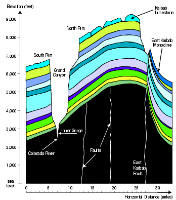
Figure 3: Grand Canyon Profile. This profile, showing the thickness, shape, and elevation of each of the major sedimentary layers, extends from 36°00'N, 112°17'W to 36°24'N, 111°56'W.17 Basement (nonsedimentary) rock is in black. Note the differing scales (vertical in feet, and horizontal in miles). At these scales, the Colorado River, at the tip of the left arrow above, would be smaller than the period at the end of this sentence. (Could that “dot of a river” carve the vast, wide canyon above it?) In general, Grand and Marble Canyons cut down into a broad arch that extends for the length of those canyons. This particular profile cuts across faults; one of the most dramatic aligns with the East Kaibab Monocline, which is discussed later. Notice how the layers under the monocline thicken to the right.
The Great Unconformity. Fossils are found only in the layers above an almost perfectly horizontal plane called the Great Unconformity. Evolutionists believe this boundary marks the time when all life on Earth began and name it the Cambrian Explosion. [See “The Cambrian Explosion on” page 13.] In the Grand Canyon, it lies about 4,000 feet below the rim and extends above the Colorado River for 66 miles. Above the Great Unconformity, the layers are all sedimentary and usually horizontal; below the Great Unconformity lie either basement (crystalline) rock or thick, sedimentary layers that slope 10°–20°.
Arching. Researchers have long noted that Grand Canyon and Marble Canyon cut down into the top of a long, 277-mile arch. Vertical cross-sections (perpendicular to the Colorado River) show how the sedimentary layers and basement rock directly below, arch upward.18 Each cross-section differs slightly, depending on its location.
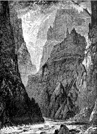
Figure 4: Inner Gorge. How could a river cut a slot, up to 1,200 feet deep, into such hard, crystalline (nonsedimentary) rock? When a river erodes down through soft sedimentary layers and encounters hard basement rock, further erosion should be primarily horizontal, into the softer, flanking sedimentary layers. Any erosion into the harder rock would form a shallow, bowl-shaped channel, not a deep, nearly vertical crack. The eroded walls of this inner gorge should be smooth, but instead, are jagged. Besides, if the river started to cut a deep slot, boulders (not easily moved by even a fast-flowing river) would fill the slot, preventing further scouring and deepening of the slot. Instead, as the Grand Canyon formed, so much weight was removed that the brittle basement rock arched up and cracked vertically. [See Figure 3.]
Our Focus. While the key question concerning the Grand Canyon is how did it form, other matters can easily distract us: the canyon’s beauty, modern history, early habitation, and exploration; the mind-numbing list of geologic terms and terrain names; and the adventure and stress of navigating its many trails and the Colorado River itself. Hundreds of books have already told these stories, so we will avoid those fascinating diversions and focus on the key question of the Grand Canyon’s origin. A reward may await us. As usually happens in science—and as you hopefully see with the flood itself—when a persistent enigma is finally solved, answers to seemingly unrelated problems become obvious.