Evidence Requiring an Explanation
Summarized below are the hard-to-explain details which any satisfactory explanation for the origin of the Grand Canyon should answer.
Layering. Probably the most striking sight at the Grand Canyon is the vastness of the parallel sedimentary layers—multicolored by their differing mineral and chemical content. Any explanation for the Grand Canyon’s layers should also explain other sedimentary layers worldwide, because they are so similar (although less dramatic).
Limestone. The Hualapai Limestone, west of the Grand Canyon, was deposited before the Colorado River flowed out the western end of the Grand Canyon. Also, many layers in the canyon consist primarily of limestone hundreds of feet thick.19 What is the source of so much limestone, and what concentrated it? If these limestone layers were deposited in shallow inland seas—the standard explanation—then the Colorado Plateau had to rise and fall at least once per layer. Explaining one lift is difficult enough.20
Marble Canyon. How does the origin of the nearly straight Marble Canyon and its narrow, vertical walls relate to the origin of the adjoining, but broader, Grand Canyon? What accounts for the strange pattern of tipped layers in the walls of Marble Canyon and Echo and Vermilion Cliffs?
Distant Cavern connection. How could a deep and dry underground cavern develop 5,400 feet above sea level but have an underground channel that drains into the Grand Canyon 63 miles away?
Side Canyons. Why do so many dry side canyons, enter Grand or Marble Canyon at the depth of the Colorado River?
Barbed Canyons. Why does Marble Canyon have large, barbed (backward) side canyons that enter the Colorado River at such surprising and large angles?
Slot Canyons. How did such narrow side canyons with jagged walls capture enough water to cut deep channels that drain into the Colorado River? Why are most of the world’s slot canyons on the Colorado Plateau?
Perpendicular Faults. Why are the dozens of faults in the Grand Canyon generally perpendicular to the Colorado River, and why doesn’t the river flow along an “easier” path provided by a fault? 21 Maybe the deep erosion that carved the canyon produced the faults.
Arching. Why are Grand and Marble Canyons cut down into and along the top of a broad, upward-pointing arch that extends, in general, for the 277-mile length of those canyons?
Inner Gorge. Why are the walls of the inner gorge so deep, steep, narrow, and rough? How could a river cut so deeply into such hard rock at the inner gorge but not as deeply into softer rock both upstream and downstream?
Nankoweap Canyon. Why did humans live for centuries in this now dry, desolate canyon? What produced the avalanche and provided a violent, multidirectional flow of water able to (1) carve Nankoweap Canyon and its side canyons, (2) create a large delta that remains today despite the cross-flowing Colorado River, and (3) stack thousands of large, rounded boulders 100–200 feet high along Nankoweap Creek? Where was enough water to do all that?
Unusual Erosion. Why are slumps, landslides, and rockfalls found on the top of Nankoweap Mesa? Why does the Colorado River sharply delineate this eroded region to the west from the smooth, lower region to the east?
Forces, Energy, and Mechanisms. Each explanation for the Grand Canyon requires lifting the Colorado Plateau more than a mile in the air and excavating and transporting thousands of cubic miles of rock. Are the forces, energy, and mechanisms for these movements known—or merely inferred or assumed? Without a knowledge of the underlying physics, which must conform to scientific laws, major errors can creep in. Even if the inferences or assumptions are correct, ignorance of the actual forces, energy, and mechanisms will blind us to root causes, rates, and other consequences. Predictions will not present themselves; modeling and testing become limited. Such “half baked” explanations simply confuse others.22
Why Here? Why is the Grand Canyon where it is, and why are there not many other “grand canyons” worldwide? 23 The canyon receives little rain. If an explanation claims that over millions of years, a set of conditions, such as a fast-flowing river produced the Grand Canyon, then dozens of other “Grand Canyons” should exist where those conditions are even more extreme.
Why So “Recently”? If the Colorado River carved the Grand Canyon during the last one-thousandth of Earth’s history, why didn’t more powerful rivers carve other “Grand Canyons?
Missing River. Limestone was deposited at the western end of the Grand Canyon before the Colorado River flowed through the canyon. Where was the river? What brought it to its present location? How was the western Grand Canyon carved?
Missing Talus. In the canyon region, why do tall cliffs, such as Echo Cliffs, Vermilion Cliffs, and others, have little talus (rubble) at their bases?
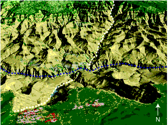
Figure 5: Grand Canyon in 3D. Grand Canyon Village is at the bottom of this computer-generated picture. The Colorado River lies below the dashed blue line. Obviously, a river did not carve all the randomly oriented drainage channels that make up the Grand Canyon. Much more water was involved. And yet, for 150 years, the public has been told that the Colorado River carved the canyon over millions of years. No wonder that explanation has so many recognized problems, even in the eyes of the so-called experts.
Surface water typically flows downhill; however, the flow of subsurface water depends in part on the location of faults and other subsurface drainage channels. Sediments deposited on the continents by the flood averaged more than a mile in depth all over the Earth. Each grain that settled through the muddy floodwaters helped trap water between the loosely packed grains. When the flood ended, approximately 20% of the floodwater was temporarily held between sedimentary grains, seeking ways to escape to the surface. Water that escaped accounts for many of today’s land features, including much of the Grand Canyon.
The dashed white line shows part of the 60-mile-long Bright Angel Fault. As Figure 29 on page 261 explains, the west side of this vertical fault (a deep fracture) rose 200 feet higher than the east side, allowing subsurface water to escape out of the freshly exposed 200-foot-high cliff face and up out of the fault. That erosion carved the prominent Bright Angel side canyon, the location of the famous Bright Angel Trail. Hundreds of less spectacular faults account for hundreds of other variously oriented valleys and side canyons that allowed escaping subsurface water to drain down to the deepest channel, where the Colorado River now flows. In other words, Grand and Hopi Lake’s water eroded the Grand Canyon first; then, the region’s natural drainage created today’s Colorado River—just the opposite of what most geologists and the Grand Canyon National Park tell us.
Kaibab Plateau. Why and how did the Colorado River make a right turn and cut up through the Kaibab Plateau, which rises more than a mile on either side of the river? What caused the Kaibab Plateau to bulge upward, like a squeezed water balloon?
Colorado Plateau. A plateau is a large region whose horizontal sedimentary layers were lifted relative to the corresponding layers surrounding the plateau.24 The Colorado Plateau rises an average of 6,200 feet above sea level. Can you see why the 1-mile-deep Grand Canyon could never have formed on land that is less than a mile above sea level? So what lifted the Colorado Plateau?
For all its glorious views, the Colorado Plateau remains an ugly mystery to geologists. They can’t figure out why and how it rose thousands of feet over the millions of years it took to carve spectacular natural wonders like the Grand Canyon and Monument Valley.25
Missing Mesozoic Rock. What swept off the soft, 1,000-foot-thick Mesozoic layer, from atop 10,000 square miles of hard, horizontal Kaibab Limestone? How could that layer have been swept off the much higher Kaibab Plateau?
Missing Dirt. The carving of the Grand Canyon removed bout 2,800 cubic miles of dirt, and yet the Colorado River’s delta does not contain even 1% of that dirt. Where did it go? Was there enough water to transport all that dirt?
Fossils. Why are fossils found only above the Great Unconformity?
Tipped Layers. Why are sedimentary layers (hundreds of feet thick) tipped at steep angles below portions of the Great Unconformity, while the layers above, averaging 4,000 feet in total depth, are horizontal?
Time or Intensity? A satisfactory proposal for carving the Grand Canyon must show, in a self-consistent way, that eons of time transpired, or there was a violent flow of water.