Proposals for the Origin of the Grand Canyon
Although not addressing the Grand Canyon, several early geologists suggested a mechanism for carving a canyon: breaching a large lake’s boundary. A large lake spilling over the lowest point on its boundary will erode a notch that will allow more water to flow through the notch faster, eroding the notch even deeper. If the lake is large, the initial loss of water will not lower the lake’s level too much, but the notch will deepen rapidly. The lake will discharge catastrophically through a deepening slit—quickly forming a canyon.26 The process is similar to the collapse of a dam. Modern examples of breached dams include the 1889 Johnstown Flood in Pennsylvania, which killed at least 2,200 people, and the 1976 Teton Flood in Idaho, which killed fourteen people and left 25,000 homeless.
In 1861, John Strong Newberry proposed an explanation for the small canyons and basins along the Colorado River far south and west of the Grand Canyon. He wrote:
Doubtless in earlier times, [the Colorado River] filled these basins to the brim, thus irrigating and enriching all its course. In the lapse of ages, however, its accumulated waters, pouring over the lowest points in the barriers which opposed their progress towards the sea, have cut them down from summit to base forming that remarkable series of deep and narrow cañons through which its turbid waters now flow, with rapid and almost unobstructed current, from source to mouth.27
Newberry also wrote that the Grand Canyon, which he called The Great Cañon, was “wholly due to the action of water. Probably nowhere in the world has the action of this agent [water] produced results so surprising, both as regards their magnitude and their peculiar character.”28
In 1923, another geologist, J Harlen Bretz, proposed that a network of canyons had been carved in Washington State by the breaching of a natural dam. He said that an ice dam impounded a lake in Montana and northern Idaho. The lake, which Bretz called Lake Missoula, held about half as much water as Lake Michigan. (Grand Lake alone held twice as much water.) When Lake Missoula breached, canyons and other terrain, called the Channeled Scablands, were carved. Because Bretz’s explanation was too catastrophic and similar to the biblical flood,29 geologists rejected his views for more than 40 years. Today, his views are widely accepted.30 (Invoking catastrophes violated a “sacred” rule in geology; i.e., explanations should involve only processes that we see today. Evolutionary geologists believe that eons of time were available. Unfortunately, this assumption, called uniformitarianism, still underlies much of geology.)
The following are the best-known published proposals for the origin of the Grand Canyon. Most assume that the Colorado River carved the canyon. All theories try to explain how the Colorado River cut through the high Kaibab Plateau. Most proposals contain few of the many details that are known today about the canyon and surrounding region.
John Wesley Powell (1869). Over geologic time, thousands of feet of limestone, shale, and sandstone layers were deposited. The Earth, cooling from its earlier molten state, was contracting and shriveling, like a dried-up, wrinkled apple. As the Colorado River flowed along its present course 65,000,000 years ago, surface rocks began folding, uplifting, and tilting. The Colorado Plateau rose so slowly that the river was never blocked. As it did, the river cut down through the rising land, leaving the Grand Canyon.31
In fairness to Powell, who had lost an arm during the Civil War, he based his explanation for the Grand Canyon’s origin on terrain he saw two months before he entered the Grand Canyon and 400 miles to the northeast. When his team reached the Grand Canyon, they were in a race for their lives, rations were running low, treacherous rapids were smashing their small wooden boats, morale was low, escape routes were limited, and constraining canyon walls permitted little exploration. Two weeks later, the local inhabitants murdered three team members as they tried to leave that hostile environment.
Grove Karl Gilbert (1875). Faults developed in the Colorado Plateau as it rose over the ages. These cracks allowed the Colorado River to flow through the Kaibab Plateau and carve the Grand Canyon.32
Samuel Franklin Emmons (1897). To form the Grand Canyon, either the Colorado River cut down through the land below, or the land below rose up and was cut by the river. Powell maintained the latter, but he misread specific geologic features. Emmons refuted Powell’s explanation,33 and maintained that the river carved the Grand Canyon by cutting down through the land, a process called superposition.
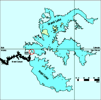
Figure 6: Grand and Hopi Lakes. The funnel region (marked by the red circle) was carved by water suddenly released from Grand Lake. [See Figures , 7, 8, and 11 for different perspectives of the funnel.] The region covered by this map lies in the southwest portion of the Colorado Plateau, which has an average elevation of 6,200 feet above sea level and an area the size of Germany or New Mexico.
Eliot Blackwelder (1934). Up until 1.8-million years ago, the Colorado River did not exist. Then, as the Rocky Mountains somehow rose their last mile or so, they intercepted more moisture from westerly winds. Rivers flowing down the western slopes of the Rockies became longer and more powerful. River drainage into basins west of the Rockies increased, while the cold, ice age climate reduced evaporation. Therefore, western lakes grew and sometimes breached their banks, carving canyons down to the next lower lake. Eventually, the Colorado River carved Grand Canyon.34
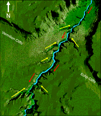
Figure 7: The Funnel and Barbed Canyons. This computer-generated picture resembles a photograph taken from 35,000 feet above the “barbed” side canyons feeding into the Colorado River. (The diagnostic importance of barbed canyons will soon be explained.) Flowing surface and subsurface water carved the barbed canyons in a direction (yellow arrows) opposite to the flow of the Colorado River today (red arrows). Notice that Echo Cliffs and Vermilion Cliffs nearly align. The funnel-shaped opening in the top right corner cut through a single cliff system, giving us these two sets of cliffs today. A giant, high-pressure hose, gushing from the upper right corner in the direction of the red arrows, would carve the funnel nicely.
Edwin D. McKee (1964). The early Colorado River flowed into the Gulf of Mexico along a path that began east of the Kaibab Plateau and continued along the valley of the Little Colorado River, finally flowing into the Rio Grande. During the next 8,000,000 years, the Colorado Plateau rose, and some streams flowed westward off the Colorado Plateau. One stream eroded headward (upstream) 300 miles northward from the Gulf of California, then 130 miles eastward through the Kaibab Plateau. The stream eventually captured the waters of the Colorado River, which then changed course and began flowing west, where it eroded the Grand Canyon.35
Charles B. Hunt (1976). The land rose under the downcutting Colorado River to form the eastern Grand Canyon. Later, the river ponded in a large basin north of Kingman, Arizona and tunneled northward through caverns and deposited the Hualapai Limestone just beyond today’s western Grand Canyon. That lake eventually overflowed and cut the western Grand Canyon. Over the next few million years, the Colorado River carved the Grand Canyon to its present depth.36
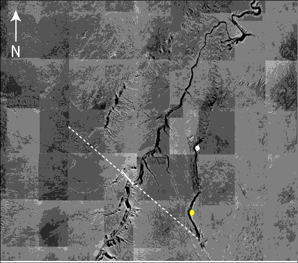
Figure 8: Aerial Photograph of the Funnel and the “backward” Barbed Canyons. The dashed white line shows approximately where Echo-Vermilion Cliffs were connected before Grand Lake breached and eroded the funnel. This was confirmed during my fieldwork by finding a long, dramatic fault39 (marked by the solid white line) and shown in Figures 30—31 on page 265.
Notice that this cliff system was parallel to the other northwest-to-southeast cliffs in the Grand Staircase to the north. All were formed as Grand Lake, to the northeast, drained through the funnel. That steady removal of the weight of the lakes’ water was equivalent to a growing upward force lifting the bottom of the draining lakes and producing a series of shearing failures. Each shearing failure raised one of the steps in the Grand Staircase—and Echo-Vermilion Cliffs.
The higher the southwest-facing cliffs (“steps”) in the Grand Staircase rose as Grand and Hopi Lakes drained, the more subsurface water spilled out of those cliff faces during the Great Denudation, and the more erosion occurred southwest of each “step.” Figure 22 on page 246 will give you a feel for the massiveness of Grand Lake’s waters.1 Supporting all of the above are Figures 9 and 10, which show what is at the yellow and white dots.40

Figure 9: Tipped Cliffs (Looking Southward). The catastrophic breaching of Grand Lake carved the funnel and removed so much mass that your eye can easily see that the land below bulge upward, including the land below the newly exposed cliffs bordering the funnel and below Marble Canyon.
Why quickly? As you read "Plateau Uplift" on page 234, you will see that immediately after the flood, frictional heating from the sinking Rocky Mountains produced magma that was injected between the former floor and roof of the subterranean chamber, lifting the Colorado Plateau. Therefore, for every ton of rock and water later removed by the breaching of Grand and Hopi Lakes, a ton of liquid magma immediately shifted directly below the eroded region preserving vertical force equilibrium and upwarping the Kaibab Plateau. This is called “the water-balloon effect.”
All 40 miles of surrounding cliffs arched upward toward Marble Canyon, producing (the “Big Crack”), although Marble Canyon is 2–5 miles away. For perspective, note the houses at the base of this portion of Echo Cliffs, marked by the yellow dot in Figure 8. Most rubble (called “talus”) is missing from the base of this 40-mile cliff system, because the water spilling out of Grand Lake and its banks for weeks swept the rubble away, and this happened only a few thousand years ago. New rubble has not had time to accumulate.
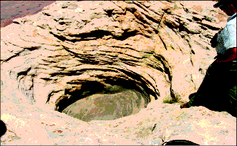
Figure 10: Potholes. Here, at almost the highest point on Echo Cliffs (the point marked by the white dot in Figure 8), is a weathered pothole.41 Partially seen at the bottom left and right are two similar potholes. A pothole forms when whirling rocks, caught in an eddy or vortex of a fast-flowing stream, grind down, carving a cylindrical depression.42 Why was water flowing so rapidly this high (6,654 feet above sea level) and at the upper edge of a 2,000-foot cliff? (In the extreme top left corner, you can see the edge of the cliff—and2,000feet below.)
When Grand Lake breached and began spilling over the Echo-Vermilion Cliff system, marked by the dashed white line in Figure 8, south-flowing water carved these potholes and the miles-wide funnel within weeks. Had the funnel been a few feet wider at this location, the rock where my geologist friend is standing would have been swept away.
That torrent of water swept at least 2,000 cubic miles of soft Mesozoic sediments off the hard Kaibab Limestone—the great denudation. Days later, and 30 miles to the south, that torrent began carving the Grand Canyon by removing 800 cubic miles of dirt. That removal of weight lifted all the land under and near the canyon. Therefore, the south end of the funnel’s floor of hard Kaibab Limestone now rises more than 1,000 feet as one proceeds southward along the top of Marble Canyon and Echo and Vermilion Cliffs. These potholes also rose. All the layers exposed in these cliffs and the walls of Marble Canyon show this dramatic tipping as does Figure 9.]
Ivo Lucchitta (1988). The early Colorado River flowed southwest across a flatter Kaibab Plateau, cutting down through it by superposition. West of that plateau, the river flowed to the northwest. Faulting and volcanism have since erased that path.
About 5-million years ago, a stream began to flow south into the newly opened Gulf of California. That stream eroded headward along what is now the Colorado River’s path after it leaves the Grand Canyon. Further headward erosion to the east allowed the stream to intersect and capture, west of the Kaibab Plateau, the Colorado River, which then carved the Grand Canyon.37
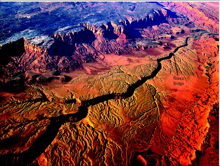
Figure 11: The Big Crack: Where Marble Canyon Began. Water from Grand Lake spilled out near the top right corner of this picture and flowed violently toward the bottom left corner, eroding this funnel-shaped region. By removing vast amounts of material, the horizontal sedimentary layers below—no longer pressed down by so much weight—arched upward, stretched, and cracked. Subsurface water then began spilling into this deep, minutes-old crack, now called Marble Canyon. Notice the many small “sink valleys” and their tiny tributaries near the edge of Marble Canyon. Drainage channels that captured much of the water spilling out of Vermilion Cliffs (at the top of the picture) and Echo Cliffs (at the bottom right) grew larger, allowing them to capture even more water. They became barbed canyons. They are somewhat evenly spaced along both sides of Marble Canyon, because water was escaping all along the water-saturated sediments at both edges of the big crack.
Today, thirty miles to the south, Marble Canyon joins the Grand Canyon, where the Little Colorado River enters the Colorado River. [See Figure .] Vermilion Cliffs and Echo Cliffs were previously joined, but today mark the funnel’s western and eastern boundaries. Highway 89A extends into the funnel in the shape of a hairpin and crosses the Colorado River at Navajo Bridge. Careful observers standing on Highway 89A can see the upward arching layers in Echo and Vermillion Cliffs. [See Figure 9.]
Norman Meek and John Douglass (2000). About 6,000,000 years ago, the Colorado River drained into Hopi Lake. Eventually, the lake breached, spilling over the Kaibab Plateau to the west. The released water filled other basins downstream, forming lakes that breached successively. The region west of today’s Grand Canyon may have subsided by almost one mile, and the Colorado Plateau may have tipped to the southwest, giving the waters from the upper Colorado River enough energy to carve the Grand Canyon.38
Walt Brown (1989)—Hydroplate Theory (summarized on pages 118– 158). The high-velocity floodwaters escaping from the subterranean chamber eroded massive amounts of sediments that liquefaction sorted into thin, horizontal layers totaling more than a mile in thickness. By the end of the flood, those water-saturated sediments held about 20% of the floodwater. The groundwater that escaped years later sculpted much of Earth’s terrain we see today.
Near the end of the flood, continent-size hydroplates (still with some lubricating water below) accelerated downhill, away from the rising Mid-Atlantic Ridge and toward the sinking Pacific plate. Within hours, the hydroplates met resistances and crashed. This compression event crushed, thickened, and buckled the hydroplates, quickly pushing up Earth’s major mountain ranges. (To see how fast, read pages 485– 486, and don’t be shocked. Just follow the evidence.) For other details, see pages 118– 158 and 203– 214.
A series of major events then occurred which produced the Grand Canyon.
a. The floodwaters drained off the suddenly thickened and elevated continents, leaving behind postflood lakes in every continental basin.
b. As the newly formed Rocky Mountains settled into the mantle, they hydraulically lifted the Colorado Plateau—and Grand and Hopi Lakes—an average of 6,200 feet above sea level. Page 234 explains this in more detail.
c. A few centuries later, Grand Lake breached its southwestern corner, causing Hopi Lake also to breach. The combined waters of both lakes and the escaping groundwater spilled off the western edge of the Colorado Plateau, swept off the soft Mesozoic sediments south and west of the lakes (the Great Denudation) and carved the Grand Canyon in weeks. Therefore, the Colorado River was born—a consequence, not the cause, of the carving of the Grand Canyon.
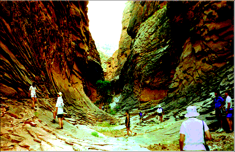
Figure 12: Inside a Barbed Canyon. Notice the unusual, curved layers bending up the sides of North Canyon, a barbed canyon that enters the Colorado River flowing south inside Marble Canyon, one mile behind my camera. How did these layers form?
As Grand Lake breached, the weight removed by the rapid erosion of the funnel caused the ground below to arch up and crack open, forming Marble Canyon. The vertical crack penetrated a 450-foot layer of water-saturated limestone 500 feet below our feet, releasing its subsurface water into Marble Canyon. Some of that limestone dissolved, just as water draining through limestone hollows out caves today. The pliable, uncemented layers above the limestone sank and tipped, forming a sink valley. Torrents of surface water then entered that valley, eroded it deeper, and carved, from the surface down, this barbed canyon in weeks. Other barbed canyons formed in a similar way. [See Figure 11.]
To understand the Grand Canyon’s origin, we must first explain some strange terrain features surrounding the Grand Canyon.
Colorado Plateau. Immediately after the flood, each newly formed mountain range began the slow process of settling into the upper mantle. (Mountains have “roots” that descend into the mantle, a fact known for over a century. The hydroplate theory explains the forces, energy, and mechanism that sank those roots into the mantle and when it happened.) The mass pushed aside by a sinking mountain range increased the mantle’s upward pressure next to that range, causing the weakest portion of the crust to break and rise. Thus, plateaus24 rose next to settling mountain ranges. Examples include the Columbia Plateau next to the Cascades, the Tibetan Plateau (the largest, highest plateau in the world) next to the Himalayan Mountains (the most massive and highest mountain range in the world), and, pertinent to the origin of the Grand Canyon, the Colorado Plateau next to the Rocky Mountains. Considerable faulting and extreme frictional heating accompanied these uplifts. As a result, melting and volcanic activity occurred within each plateau. Large blocks, when lifted and tilted, became cliffs and mountains—called block-faulted mountains. North of the Grand Canyon are many examples: Utah’s Book Cliffs, Roan Cliffs, the Grand Staircase (Pink Cliffs, White Cliffs, Chocolate Cliffs, Vermilion Cliffs, Gray Cliffs), and others. As the floodwaters drained, continental basins became postflood lakes, some quite large.
The Funnel. Imagine a postflood lake with twice as much water as Lake Michigan, 5,700 feet above today’s sea level, high on the Colorado Plateau. We will call this lake, Grand Lake. About 15–20 miles southwest of Grand Lake is the top of the long Echo-Vermilion Cliff. Drainage into the lake from higher elevations, and possibly the breaching of even higher lakes, increases Grand Lake’s depth. Water drains from under Grand Lake, emerging as springs from the face of this 2,000-foot cliff system. Increasingly, the ground sinks along that drainage path between the lake and the cliff. Suddenly, Grand Lake breaches at a point on its bank and catastrophically erodes the soft Mesozoic sediments, forming a gigantic spillway—a steep, 18-mile-long channel shaped like a widening funnel. Within weeks, large volumes of escaping high-velocity water erode the far end of the funnel to a width of 12 miles and a depth of 2,000 feet.
Marble Canyon. The initially horizontal sedimentary layers below the floor of the funnel steadily arch upward as this downward erosion removes weight. Eventually, the funnel’s floor—hard, brittle Kaibab Limestone—cracks in tension, splitting open the entire floor parallel to the funnel’s axis, forming Marble Canyon. [See Figure 11.]
Aquifers (porous, water-saturated, sedimentary layers) cut by this deep vertical crack rapidly spill their waters, like large ruptured water mains, into the newly formed Marble Canyon. Subsurface channels draining into Marble Canyon begin to form. Initially, this underground flow is perpendicular to the canyon walls.
Days later, the erosion of the Grand canyon removed so much mass, that the deep layers to the south of Marble Canyon had to rise. This forced the underground flows near both edges of the newly formed Marble Canyon northward, so they merged with the water spilling out perpendicular to Marble Canyon, forming a hook-shaped (or barbed flow pattern). Directly above these growing underground drainage channels, the earth sank, forming barbed canyons. Instead of sinkholes, we have hundreds of shallow “sink valleys.” [See Figures 11 and 12.] For months, the underground channels, were enlarged by all the sediments removed by the escaping water, so the larger underground “pipes” capture even more water.


Eventually, only a few very large, subsurface drainage channels are spilling out at fairly even intervals along Marble Canyon. Also, water pouring out of the sides of the funnel spills into some sink valleys more than others, eroding and deepening them, so they capture more surface water and erode even deeper. [See Figures 11 and12.]
Grand Canyon. The south-flowing torrent of water spilling from Grand Lake undercuts the northwestern corner of Hopi Lake (elevation 5,950 feet), releasing its waters as well. Their combined waters, now sweeping westward over northern Arizona, first remove at least 1,000 feet of the soft Mesozoic sediments above the hard Kaibab Limestone. As this weight is removed from almost 10,000 square miles south and west of the funnel, deeper sedimentary layers arch upward, stretching and in many places cracking open the hard, brittle Kaibab Limestone above.
Near the breach point on Hopi Lake’s high shoreline, a waterfall, about thirteen times higher (with possibly a hundred times greater flow volume) than Niagara Falls bursts forth. The torrent from “Hopi Falls” plus the flow from Grand Lake sweeps away so much rock that deeper rock must rise—not just directly under the deepening channel, but under the flanks of the channel as well. [Figures 63 and 66 on pages 130 and 132 explain this well-understood engineering phenomenon—the buckling of a plate on an elastic foundation.] The faster rock rises into the torrent, the more mass the combined flows sweep away, so deeper rock—and the flanks of the channel—also rise. A similar mass removal and lifting of the flanks take place along the southern flow inside Marble Canyon. This is clearly seen in the steeply tipped layers in Echo and Vermilion Cliffs, all along Marble Canyon. [See Figure 9 on page 236.] Therefore, the Kaibab Plateau is pushed up by the combined lifts west of the southern flow and north of the western flow. This channels and focuses the western flow through the lowest path, so even more mass is swept away. (Recall that the Mesozoic layers had been swept off days or weeks earlier.) Blocks of rock breaking loose and rising from so many different places under the Kaibab Plateau accounts for its steep, unusually hilly topography. For further insight into why the Kaibab Plateau rose and bulged upward, please study Endnote 44 and Figure 32 on page 267.
About 20% of the volume of sediments on the rapidly rising Kaibab Plateau is subsurface water. The higher the plateau rises, the greater the water’s energy and eroding potential. For weeks, landslides, slumps, and mudflows spill down the rising slopes of the Kaibab Plateau from multiple directions. Powerful springs erupt from around the base and sides of the plateau; many will flow without major seasonal variations for centuries, making Nankoweap [Figure 2 on page 226] an excellent habitat for humans for decades. Some drainage carves deep channels around Nankoweap Mesa, which is topped with earlier slumps, landslides, and rockfalls. Other springs carve Nankoweap Canyon, cutting through thick mud and slump deposits, exposing boulders stacked up to 200 feet high along Nankoweap Creek. Rocks, mud, and water spilling eastward off the Kaibab plateau can go no farther than Marble Canyon, which acts as a gutter, channeling and intensifying the southward flow. Thus, the land east of Marble Canyon is shielded from spillage off the higher, rising Kaibab Plateau.
Meanwhile, cascading waters from Grand and Hopi Lakes have begun eroding a 216-mile path to—and down through—the western edge of the Colorado Plateau. The deeper the waters cut below the high postflood water table, the more high-pressure water is released from the flanks of the lengthening channel. Each sedimentary particle becomes a cutting tool carried by the rapidly-flowing (and falling) water. As more sediments are eroded, more “liquid sandpaper” becomes available to erode more sediments. Additional energy is provided by the release of this mile-high, subsurface water. In weeks, 800 cubic miles of sediments from the Kaibab Limestone and below are removed, forming the Grand Canyon.
Although Marble Canyon adjoins the Grand Canyon, their different shapes and widths earned them different names. The canyons’ differences are explained when one realizes that the change occurs where the northwest corner of the higher Hopi Lake was undercut by the rushing waters from Grand Lake—where the Little Colorado River now joins the Colorado River. Simply stated, the waters of Grand Lake helped carve Marble Canyon; the merged waters of both Grand and Hopi Lakes helped carve the Grand Canyon. Today, Grand Lake’s basin is drained by the Colorado River and several of its tributaries, and Hopi Lake’s basin is drained by the Little Colorado River. Both basins were once filled with silica-rich water that quickly escaped. Supporting evidence—mesas, buttes, spires, petrified forests, extreme meandering rivers, side canyons, and hundreds of huge “pits” excavated by powerful, erupting springs—will now be explained. [Mounds, another category of evidence, are explained on pages 206– 209.]
Side Canyons of Grand and Marble Canyon. Marble Canyon and Grand Canyon were rapidly cut thousands of feet below the high postflood water table. Subsurface water, some traveling great distances,15 exited from the flanks of these canyons and may have exceeded the water in both Grand and Hopi Lakes combined. That escaping water cut dozens of large, previously unexplained side canyons that now enter Marble and Grand Canyons at the level of the Colorado River. Most of these side canyons have no appreciable water source today. A few are “backward.”
Barbed Canyons. With all this weight quickly removed from the Grand Canyon region, the rock layers below rose, so layers north of the Grand Canyon sloped down to the north. Thus, subsurface water near Marble Canyon (and the sink valleys above) drained northward. Water spilling out of the funnel walls—Vermilion Cliffs on the west and Echo Cliffs on the east—flowed into and deepened the northward-draining sink valleys, giving them the shape of the barbs in barbed wire. Although tributaries almost always enter rivers at acute angles, the barbed canyons are oriented at obtuse angles to the Colorado River; they are “backward.” Some barbed canyons are huge—a mile wide and 1,700 feet deep where they enter Marble Canyon.
Side canyons into Grand and Hopi Basins. Grand and Hopi Lakes emptied in weeks, so the water tables surrounding their basins quickly found themselves hundreds of feet above the dropping lake levels. Perhaps several Great-Lakes’ worth of high-pressure subsurface water began seeking underground escape routes into those draining basins. Escaping groundwater exploited faults formed during the uplift of the Colorado Plateau and other underground channels many miles long. Those channels became destinations for even more escaping groundwater. The more water that flowed through these underground channels and their tributaries, the larger they became. In this way, hundreds of canyons formed that today enter the basins of the former Grand and Hopi Lakes.
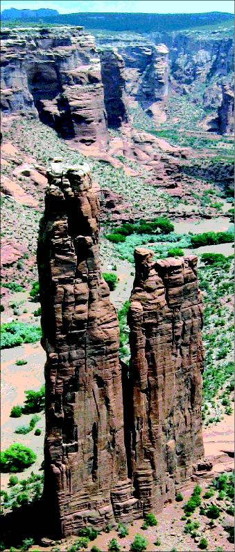
Figure 15: Spider Rock in Canyon de Chelly. Five side canyons (not shown) converge on this 800-foot spire: from the north, northeast, east, southeast, and south. It is hard to imagine terrain that would allow five surface streams (which always flow downhill) to carve canyons that converge at the same point from such different directions. However, subsurface flow, (which is always in the direction of decreasing pressure), can produce this effect. Obviously, Spider Rock was cemented before the water that carved these canyons swept through this location.
One of the most picturesque is Canyon de Chelly (de-SHAY), a group of canyons up to 25 miles long that radiate east of Chinle, Arizona. Canyon de Chelly enters Grand Lake’s basin from the east, near its southernmost location in Arizona. [See Figure on page 214.] Streams and rivers produce canyons with V-shaped cross-sections, but most of Canyon de Chelly has a U-shaped cross-section. U-shaped cross-sections are produced by glaciers or by groundwater flowing out from and undercutting canyon walls. Because no other glacial characteristics are found within 500 miles, subsurface flow—not glaciers—probably carved Canyon de Chelly.
Also, Canyon de Chelly has abundant rock debris at the base of its upstream walls but little debris at the downstream end, because only the downstream end was swept by the force of all the water flowing out from the walls along the canyon. Relatively little high-velocity water would have passed through the canyon’s upstream portions. Subsurface flow is also inferred at a few points on the south rim of Canyon de Chelly where side canyons begin at ridge lines.50 (Little surface water flows from a ridge line, but much subsurface water can flow from beneath a ridge line.)
Mesas, Buttes, and Spires. No land features symbolize the American Southwest more than mesas, buttes, and spires. [See Figure 16.] A mesa, which means table in Spanish, is a flat-topped feature (with vertical walls formed by erosion) which rises above the surrounding terrain. A mesa is wider than it is tall.51 A butte is similar, but it is taller than it is wide. A very slender butte is a spire.
The towering walls of these formations are strikingly vertical. How and when did they form? There are two dramatically different explanations—one requires millions of years; the other only several weeks.52 Why are buttes and spires concentrated in Grand Lake’s basin? There, adjacent buttes contain corresponding horizontal layers at the same level, showing that they were once connected. What removed the huge volume of sediments between the buttes, and where did the sediments go? Butte perimeters are not streamlined, but scalloped and irregular, so streams did not carve them. (Besides, rivers and streams do not meander enough or flow in circles—a necessary first step if rivers carved buttes.) Nor did wind carve these features, because large, nearby sand dunes are missing. What happened?
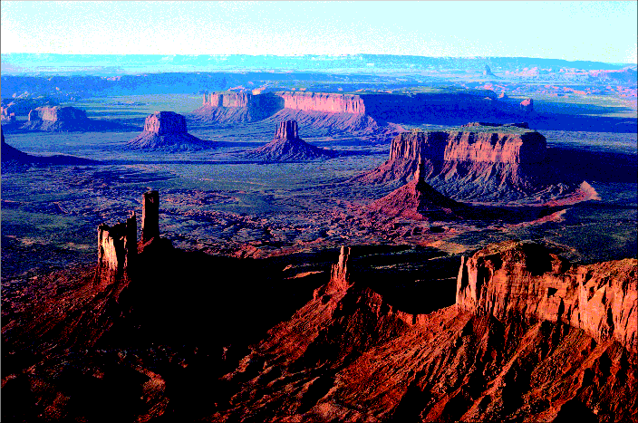
Figure 16: Monument Valley: Part of the basin that held Grand Lake. On the Arizona-Utah border is Monument Valley, the world’s most famous location for mesas, buttes, and spires—and a familiar setting for Hollywood’s western movies. These features and Grand Lake extended thousands of square miles beyond Monument Valley. Grand Lake existed for at least a few centuries after the flood. The long cliff spanning the horizon marks a small part of Grand Lake’s boundary. As Grand Lake spilled and began carving the Grand Canyon 100–250 miles to the southwest of Monument Valley, groundwater, no longer trapped under the lake, surged upward through the lower portions of the lake floor and within weeks carried off the material that connected these stark and magnificent landforms. Since Grand Lake drained a few thousand years ago, weathering has produced the piles of debris at the base of each mesa, butte, and spire.
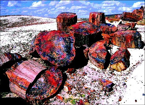
Figure 17: Broken Logs in Arizona’s Petrified Forest. For a log to snap this cleanly, it must be brittle, as a petrified log would be. To petrify, a log must be saturated with a silica-rich solution, probably in a lake. Then, the silica must come out of solution, which requires the water to cool. A petrifying log (as it gains the added weight of these minerals) would settle gently onto the lake’s floor and not break. Because this log broke into many similar-length (but reoriented) pieces, the entire petrified log probably received a powerful impact. How?
Why would a heavy, petrified log lying on a lake floor break into many randomly oriented pieces? However, if the boundary of a large lake breached, as in the collapse of a dam, the water would rush out in a torrent, carrying even sunken petrified logs for some distance. A rapidly moving, brittle, petrified log “crashing” back onto the lake bottom would break up, much as an aircraft crashing in a field.
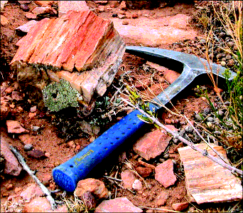
Figure 18: Petrified Wood on a Butte (Shinumo Altar). Obviously, tons of petrified wood did not wash up onto the top of this 500-foot-high butte. Nor is there reason to believe that a major lake, with silica-rich water and floating logs, was once on the very flat top of this butte. Instead, water from the breaching of Grand Lake (11 miles to the north) transported petrified logs to this spot, and then the material around the butte was removed. About 17 miles to the south, the escaping water undercut the northwestern corner of Hopi Lake. Surging waters from both lakes rapidly carved the Grand Canyon.
Beneath Grand Lake’s basin today is a 1,400-foot-thick layer of sandstone. When Grand Lake was present, that sand was uncemented and saturated with water. Because sand grains are hard and somewhat rounded, water-saturated sand layers contain up to 40% water by volume. As the lake emptied, the relatively large channels between these grains allowed the high-pressure water under Grand Lake to discharge rapidly upward, through the lowest portions of the lake bottom—the easiest routes of escape. With those upward torrents of high-pressure water came a mix of swirling sand and dirt that was quickly swept out of Grand Lake and down through the Grand Canyon, which was forming 100–250 miles to the southwest. The highest portions of the lake bottom, including islands, offered the greatest resistance to the upward-surging flow, so those high regions remained intact. Cliffs (along some lake boundaries) and mesas and buttes (internal to the lake) began to take shape.
Imagine sitting on the bottom of a shallow swimming pool. Your head barely sticks out of the water and, therefore, is an island. You exert little pressure on the bottom of the pool, because your body is buoyed up by the surrounding water pressure. You almost float. Suddenly, someone pulls the plug, and the pool rapidly drains; now, your entire weight presses against the floor of the pool. Had you been a newly forming butte resting on the floor of the rapidly draining Grand Lake, you would quickly press down on 1,400 feet of water-saturated sediments. It would be as if a 250,000,000-ton rock, with only a ≠-square-mile base, slowly settled down on a water-saturated, 1,400-foot-thick sponge. Water would surge upward and erode the sides of the rock, making the butte slender, its perimeter scalloped, and its walls vertical. The banks of Grand Lake, now quite high, would also increase the pressure on the 1,400 feet of water directly below. If that water could escape upward, a bank segment would become a cliff. This is why so many mesas and buttes formed in Grand Lake as the floodwaters drained from the Earth.
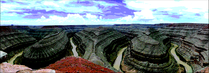
Figure 19: Goosenecks. One of the world’s most famous meandering rivers or streams is the San Juan River, which flows entirely within the basin of the former Grand Lake. Here, near the town of Mexican Hat, Utah, is a section of the river, called Goosenecks, where the river has cut down through 1,000 feet of sediments and meanders 5 miles over a distance of only one straight mile. Similar meandering extends 11 miles upstream and 11 miles downstream from this location. Is there a reason for such extreme meandering in Grand Lake’s basin?
Petrified Forest. Probably the world’s largest concentration of petrified wood is in the Petrified Forest National Park in Arizona. Few people realize that this park lies inside the basin that held Hopi Lake. Why does wood petrify, how were these unusual conditions met so abundantly in Hopi Lake?
Many people have the mistaken impression that petrification of wood requires millions of years. No. Researchers have duplicated petrification in laboratories. Wood petrifies when (1) mineral-rich water saturates the wood, and (2) some of those dissolved minerals precipitate into the tiniest voids in the wood’s cells.53 Usually, the water is rich in silica (SiO2), which forms quartz when it comes out of solution. (The solubility of quartz in water increases enormously as the water’s temperature rises. Conversely, as the water cools, silica is forced out of a saturated solution54 and becomes quartz.55)
Today, a log floating in a lake will not petrify, but will eventually disintegrate. To petrify a log, water containing dissolved silica or other minerals must saturate the log, and those minerals must come out of solution before the log disintegrates. Some petrified wood shows intricate cellular detail, indicating rapid petrification before the wood had time to decay.56 Silica comes out of a saturated solution that cools, but today’s lakes are already cool, so they contain little dissolved silica. How, then, did petrification occur?
Consider the extremely hot, high-pressure water in the subterranean chamber before the flood. [See page 126 for information on supercritical water.] The chamber’s roof and pillars were granite. About 27% of granite’s volume is quartz. Quartz in contact with hot, high-pressure water quickly dissolves.57 Although the temperature of the supercritical waters dropped rapidly as they rose, expanded, and spilled onto the Earth, those floodwaters, supersaturated58 with silica, were still warm. Therefore, large floating logs59 in postflood lakes could easily petrify as temperatures dropped. That occurred in the former Hopi Lake, as seen in today’s Petrified Forest National Park.
Finally, notice in on page 214 that Petrified Forest National Park lies in the southeastern end of Hopi Lake’s basin, where prevailing winds (which are from the west) would have drifted floating logs.60 Also, petrified logs lying on the bottom at that east end of the lake would be least disturbed by all the waters spilling out the west end. This accounts for the high concentration of petrified wood in this most famous petrified forest.
Grand Lake’s basin also contains Utah’s Escalante Petrified Forest and petrified wood along the Green River. Some petrified wood was swept out of Grand lake. For example, between the points where Grand Lake breached and Hopi Lake breached is Shinumo Altar, a 500-foot-high butte capped by hard rock.61 Petrified wood is scattered over its flat top. (Nearby residents report that petrified logs 7–10 feet long were once on the butte, but a helicopter removed them in about 1999.62) As Grand Lake’s waters spilled toward Hopi Lake, petrified wood lying on the bottom of Grand Lake was swept onto flat ground that became the top of Shinumo Altar. [See Figure 18 and, on page 214, .] Days or weeks later, the butte formed as the cascading water stripped off 500 feet of the surrounding, softer Mesozoic rocks not protected by a hard cap. I found pieces of petrified wood scattered in Hopi Lake’s basin.
Meandering Rivers. Several rivers meander dramatically within the basins of the former Grand and Hopi Lakes. Goosenecks State Park, along the San Juan River, contains the western hemisphere’s most extreme segment of a meandering river or stream. Why do rivers meander, and what conditions produce such extreme and deep meandering in a river that today is so small and sluggish?
A river flows faster on the outside of a bend than on the inside, just as the outside of a merry-go-round travels faster than the inside. The centrifugal force (pushing outward) then raises the water level on the outside of a bend. Therefore, the river’s surface water flows toward the outside of a bend, and the bottom water completes the circulation by flowing toward the inside. So a river flows in a corkscrew (spiral) pattern around a bend.
Sediments eroded by the faster flow, along the outer bank, are transported to and deposited near the inner bank, where the flow is slower and less able to carry sediments. Even on rivers that are initially fairly straight, slight curves expand and meandering increases, if the flow is fast, high, and steady.
Meanders occur on broad, flat flood plains. Deep meanders, as seen in Figure 19, require a large flood plain with deep, loose sediments. The flow out of Grand Lake encountered a major bottleneck, slightly downstream from what is now the Goosenecks region, so the flow slowed and dropped its sediments. [See on page 214.] After the bottleneck, the flow was rapid, so sediments were scoured, and the channel deepened.
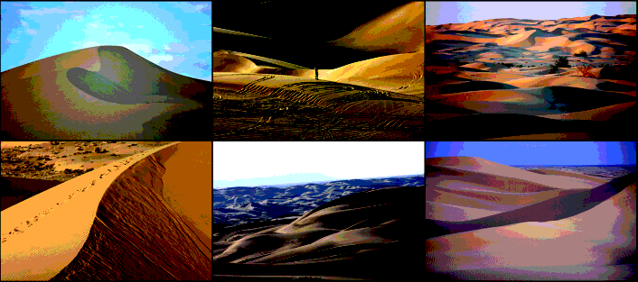
Figure 20: California’s Imperial Sand Dunes, also called the Algodones (Al-ga-DOE-nez) Sand Dunes. Where did all this clean, pure sand (2.5 cubic miles worth) come from? Why is it here in a 45-mile-long and 5-mile-wide valley?
After the lake emptied, subsurface water steadily drained into the large San Juan Basin all along its 1,000+-mile perimeter, making the San Juan a powerful river for centuries, especially along the steep channel eroded down through the bottleneck and slightly beyond. This steepness, slight headward erosion back through the still loose sediments, and the high volume of water provided the considerable energy needed to excavate the meandering river’s outer banks to the extreme extent seen today.
Why did the Goosenecks develop such uniform and symmetrical meanders? Today, rivers are fed mainly by surface flow, so their depths, sediment loads, and volume flow rates are seasonal. This produces varying meander patterns. However, the early San Juan was fed largely by subsurface water steadily draining during all seasons into the vast San Juan Basin, so centuries of fast, steady flow conditions produced uniform, symmetrical meandering patterns.
California’s Imperial Sand Dunes is one of the largest dune complexes in North America, covering 200 square miles and containing about 2.5 cubic miles of sand. It extends 45 miles up the Imperial Valley between Yuma, Arizona, and the Salton Sea.
In his geology textbook, Richard Flint estimates that wind slowly blew all that sand in over “at least 160,000 years.” 63 He does not identify the source of the sand, why wind concentrated it there, or why little dirt was blown in. Others say that the Colorado River fed an extinct lake they call Lake Cahuilla (ka-WEE-ah) and provided the sand. However, lakes rarely have the energy to break up rock to produce so much sand, but they do produce mud and clay that are largely missing from the dunes. Here is my explanation:
The sudden breaching of Grand and Hopi Lakes carved the Grand Canyon and gave birth to the Colorado River. A few thousand cubic miles of sand and other sediments were transported south, along the Arizona-California border (the path now occupied by the Colorado River). That surge far into the Gulf of California also flooded the long, Imperial Valley that extends northwest of Yuma. Sediment-laden water quickly filled that valley, because its entire length is about 700 feet lower than the Colorado River as it exits the Grand Canyon, and much of the valley is below today’s sea level. Within the turbid floodwaters, sand (as opposed to mud and clay) would have quickly settled out. [See Endnote 6 on page 263 to recall how gritty the Colorado River was.] After the crest of the flooding Colorado River passed the southeast end of the Imperial Valley, most of the valley’s waters would have drained back into the Colorado River and ultimately into the Gulf of California. Left behind in the valley were large volumes of sand and the Salton Sea, whose surface today is about 220 feet below sea level.

PREDICTION 15: A chemical and isotope analysis of the sand dunes will show that the sand came from the Grand Canyon.
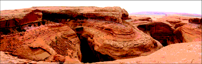
Figure 21: A Very Deep Pit. Along Grand Lake’s eastern boundary, just east of Rock Point, Arizona, are at least a hundred huge pits. (A 20-story building could be dropped into the one shown above.64) These pits have no visible source of water that could have carved them, nor could the terrain direct much surface water to this spot. If surface water could not have eroded these pits, then subsurface water did. (The YouTube film clips mentioned on page 195 demonstrate on a small scale how this subsurface water erupted.) My camera is looking over a small portion of Grand Lake’s basin in the distance. Behind me, the land rises steeply to the east, reaching 9,412 feet, 24 miles away. [See Figure on page 214.] As Grand Lake discharged, a huge reservoir of subsurface water, at the prior level of the lake, but just inside the lake’s boundary, erupted as powerful springs into Grand Lake’s draining basin, excavating these pits. The lake must have been present for some time to establish the water table far beyond the lake’s shoreline.
Mud settles slowly out of standing water. Because little mud lies in the dunes area, the valley was probably filled with gritty water only briefly. This is consistent with the few weeks I estimate it took to carve most of the Grand Canyon. Since this flooding, winds concentrated the sands a few miles to the east, along the western side of the Chocolate Mountains, which parallel the Imperial Valley and act as a barrier to the prevailing winds blowing sand eastward.
Question 1: Was the Grand Canyon formed by draining water at the end of the flood?
The list of "Evidence Requiring an Explanation" on page 228 and Figure 123 on page 220 give many reasons the water source could not have been the Colorado River.
Also, a little thought will show that the Grand Canyon was not carved simply by draining surface water at the end of the flood. If floodwaters draining all over the Earth at the end of the flood carved the Grand Canyon, there should be hundreds of similar huge canyons worldwide. An attempt to show that the canyon formed at the end of the flood produced no evidence (as explained in Endnote 9 on page 577), but the answer to Question 2 below provides evidence that the Grand Canyon was carved in weeks at least a few centuries after the flood.
Deep water draining off a continent after a flood erodes relatively little solid material per volume of fluid. Most erosion occurs within the thin boundary layer at the fluid-solid interface. Therefore, a thin, fast, continuous sheet of water spilling downhill from large lakes will transport large volumes of sediments. This accounts for “the Great Denudation” over 10,000 square miles—in the funnel and south and west of the funnel—and the carving of the Grand Canyon. Likewise, 2,000-foot waterfalls spilling from both Grand and Hopi Lakes had great eroding power.
Everyone agrees that water carved the Grand Canyon, but there would be no Grand Canyon if it were not sitting on a mile-high plateau. (Great height gives water the great energy needed to carve and remove so much material.) So,
a. how and when65 was the Colorado Plateau lifted an average of 6,200 feet above today’s sea level, and
b. how did so much water rise that high?

Figure 22: The Basin that Held Grand Lake. Here’s where it all began. This basin is a “smoking gun,” showing that its waters drained rapidly. If a lake evaporates or drains slowly, the bottom sediments are not disturbed. But here in southeastern Utah, at Canyonlands National Park, we see from the many irregular erosion features, that this basin, filled to the top of the cliffs you see on the horizon, drained catastrophically. Only by the extremely rapid flow of a vast amount of deepwater—twice as much water as in Lake Michigan1—will such extreme erosion occur and sweep all eroded sediments—not just out of our view, but out of the entire basin, which is twenty times larger than what we see in this picture. The sudden breaching of Grand Lake produced those high flow velocities, carved the Grand Canyon, and produced other spectacular scenery in the American southwest. This is why so many spectacular national parks are so close to each other and on or adjacent to the Colorado Plateau: Monument Valley, Canyon de Chelly, Zion, Bryce, Arches, Capitol Reef, Petrified Forest, and Canyonlands.
Notice that a single river didn’t carve these features, because the eroded channels do not form one long meandering path or the branching tributary pattern of rivers. Instead, multiple, fast-flowing currents acted simultaneously—as we would expect right after a natural dam that held back two Lake Michigans suddenly collapsed.
The funnel—a steep, 18-mile-long spillway, through which Grand Lake’s water escaped, is134 miles to the southwest of this location (N 38°23.347', W 109°52.0866’), and in the direction our camera points. From there, the water eroded the northwest corner of Hopi Lake, releasing its waters as well. The combined flows from Grand and Hopi Lakes, plus an immense amount of subsurface water released by the deep erosion of over 300 miles of canyons and side canyons that cut through water-saturated sediments laid down during the flood, transported 2,800 cubic miles of sediments far into the Gulf of California.
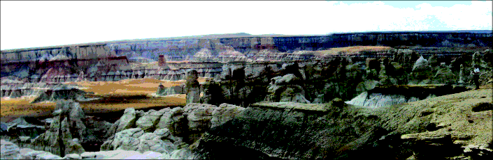
Figure 23: The Basin that held Hopi Lake. My geologist friend at the extreme right gives the scale. Several hundred square miles of the lake’s floor were eroded and swept away by the rapid drainage following the breaching of Hopi Lake.67 (No surface water exists today to do this excavation.) The escaping waters also carved the canyon that today carries the Little Colorado River. The basin’s sediments, which contain petrified wood and a thin layer of coal, were then transported through the rapidly forming Grand Canyon, 50–200 miles to the west. The presence of petrified wood shows that as the lake cooled over many years, silica in the silica-rich waters came out of solution and lodged in the tiniest pour spaces of the trees floating and soaking in the lake. The world-famous Petrified Forest National Park also lies in this basin, about 80 miles to the southeast. Can you see why this picture is similar to the top picture (Figure 22)?
Today, if all land above sea level were pushed below sea level, so all Earth’s water was raised as far as possible from the center of the Earth, sea level would rise only 800 feet,66—not enough to cover the Colorado Plateau that today rises 6200 feet above sea level. Therefore, (1) draining flood water did not carve the Grand Canyon as some have claimed, and (2) the Colorado Plateau, littered with marine fossils, must have risen by more than a mile after the Genesis Flood. (As explained on page 124, plateaus were lifted slowly after the flood by the sinking of major mountain ranges that were suddenly buckled up during the compression event.) Right after the flood, lakes were much more abundant than today, because continental basins (formed primarily during the compression event) retained much of the draining flood water. Over time, some lakes lost water by evaporation, seepage, or breaching. However, lakes on the upwind side of mountain ranges received much of the heavy, postflood precipitation the mountains intercepted. Lakes also gained water and deepened (even at high elevations) from springs flowing out of mountains and freshly elevated cliffs. [See Endnote 46 on page 214.]
Question 2: When did Grand Lake breach its natural dam?
After the flood, several very time-consuming processes had to occur before Grand Lake breached.
a. The Rocky Mountains had to sink into the mantle enough to lift the Colorado Plateau 6,200 feet above sea level. This required injecting 2,500,000 cubic miles of rock under the rising plateau—a huge task.) [See Professor Kennedy’s description on page 124.] Waters on that high plateau then had enough energy to erode at least 2,000 cubic miles of soft Mesozoic rock over almost 10,000 square miles and to erode another 800 cubic miles to form the Grand Canyon.
b. Enough time had to pass to cement certain objects exposed to the torrent of water from Grand and Hopi Lakes. Had tall spires, Shinumo Altar, boulders 200 feet above Nankoweap Creek, and thousands of giant caves not been firmly cemented, they would have disintegrated when these lakes discharged. Grand Lake’s basin contains hundreds of massive liquefaction mounds, explained on page 207. They must also have been firmly cemented when the basin’s water spilled out.
c. Enough time had to pass for the 350-foot-thick layer of Kaibab Limestone to harden in the presence of so much subsurface water, including water in the thick Mesozoic sediments above. (Hardening made the limestone brittle, so it cracked as shown in Figure 11 on page 237. Cementing also allowed the limestone to resist the torrent of water that swept over northern Arizona during “the Great Denudation.”) Hardening had to occur before the potholes shown in Figure 10 could form.
d. Enough time also had to pass for Hopi Lake to cool and its silica-rich waters to soak into and petrify floating logs. Arizona’s world-famous Petrified Forest National Park is in the basin that held Hopi Lake. Some smaller petrified forests are in Grand Lake’s basin.
e. The production, eruption, and solidification of lava had to occur at a few dozen isolated parts of northern Arizona before Grand and Hopi Lakes breached. Otherwise, the softer rock below those lava flows would have eroded. For example, Red Butte, 16 miles south of Grand Canyon Village, rises 1,000 feet above the surrounding terrain. It was already capped by hardened lava when the torrent of water spilled out of Grand Lake.
f. Time was required for animal migration to the Grand Canyon region. Some squirrels probably completed their migration before the canyon formed.68
g. Three legends of Native American tribes living near the Grand Canyon contain surprising elements consistent with the scientific evidence presented in this chapter concerning the canyon’s formation.69 This suggests humans were living in the region when the Grand Canyon formed. If so, some length of time was needed for humans to migrate to the Grand Canyon region.
Therefore, the Grand Canyon probably formed at least a few centuries after the flood.
Question 3: Why do we not see clear shorelines around the boundaries of the former Grand and Hopi Lakes?
Shorelines remain around several extinct lakes, such as Lake Bonneville and Lake Missoula, but the situations at these lower lakes were quite different. After the flood, magma injected below the Colorado Plateau, lifted it, and Grand and Hopi Lakes 6,200 feet above today’s sea level. [See Professor Kennedy’s description of this injection beginning on page 124.] This altered the shapes of the lake basins—and shifted their shorelines. Shifting shorelines have less time to leave permanent etchings in the rocks at each level. The shifting liquid below tipped the rising plateau in various ways. A tipping of only one-tenth of one degree (0.1°) would have shifted shorelines horizontally at Grand Lake and Hopi Lake by an average of several miles.70 Multiple tippings about different axes or an axis far from the lakes’ centers would multiply this effect. Lake Bonneville and Lake Missoula were not lifted on a plateau by a shifting hydraulic liquid—and, therefore, remained stationary. Faulting and volcanism among the thousands of uplifted and tipped blocks of the Colorado Plateau further changed shorelines.
Lake Bonneville and Lake Missoula most likely breached centuries after Grand and Hopi Lakes, giving Bonneville and Missoula more time to etch their shorelines. The frequent thunderstorms on the Colorado Plateau would have tended to erase any shoreline markings.
The powerful hydraulic pressure, described on page 234, that lifted the Colorado Plateau also block faulted and lifted many large southwest-facing cliffs north of Grand and Hopi Lakes, such as the Book Cliffs, Roan Cliffs, and the Grand Staircase. Water from the water-saturated, flood-deposited sediments escaped from these freshly exposed cliff faces and fed into and steadily deepened Grand and Hopi Lakes—as did drainage from higher elevations and heavy postflood rainfall on the upwind side of the Rocky Mountains. Therefore, lake levels rose, and shorelines expanded and shifted for many years after the flood.
As Grand and Hopi Lakes emptied, subsurface water surrounding their basins automatically became higher relative to the dropping lake levels. Therefore, powerful springs erupted into the draining basins. That water often removed shoreline segments and undercut the basins’ steeper slopes, forming cliffs in and around these lakes, and sweeping debris (talus) away. Consequently, many shorelines of Grand and Hopi Lakes are marked—not by small shelves as with Lake Bonneville and Lake Missoula—but by cliffs. Supporting this explanation is Dr. Edmond W. Holroyd’s detailed study71 showing that a remarkable number of cliffs lie on the boundary of Grand Lake.
Travelers driving through or flying over the basins of Grand and Hopi Lakes see land that differs from adjacent terrain. The basins have a smoother texture, lighter color, and sparser vegetation. A frequent comment is, “It looks like a lake bottom.” Indeed, Holroyd, using satellite photographs, observed that “the ‘lake’ outlines surround naturally bright regions of the Colorado Plateau.”72 Nearby regions at the same elevations, but outside these basins, do not have these “bright” characteristics.
PREDICTION 16: The soil chemistry in the basins that held Grand and Hopi Lakes will differ from that of their surroundings.