1. See Endnote 89 on page 408 to see how this energy was calculated.
2. The plate tectonic theory, as first proposed, had 6 to 8 plates. This number has grown as followers of the theory have applied it to specific regions of the Earth and found problems with the theory. Although textbooks usually mention only about a dozen plates, the theory now requires more than 100, most of them small.
This is reminiscent of the use of epicycles, from A.D. 150 to 1543, to explain planetary motion. Ptolemy (A.D. 100 –175) proposed that planets revolved about the Earth on epicycles—wheels that carried planets and rode on the circumferences of other wheels. As more was learned about planetary motion, more epicycles were required to protect Ptolemy’s geocentric theory. Any theory can appear to explain facts if the theory has enough variables (adjustable parameters).
Both the plate tectonic theory and the hydroplate theory claim that plates have moved over the globe. The plate tectonic theory says that plates move, by an unknown mechanism, slowly for hundreds of millions of years. The hydroplate theory, using an understood mechanism, says that a few hydroplates moved rapidly near the end of a global flood. Upon collision, they fragmented into pieces which today are shifting slowly, but in jerks, toward equilibrium.
As historians of science know, old theories frequently accumulate many anomalies—discoveries that oppose the theory. These problems do not overthrow the theory until a new theory comes along that can explain all that the old theory did plus the anomalies. [See Thomas S. Kuhn, The Structure of Scientific Revolutions (Chicago: The University of Chicago Press, 1970).] Plate tectonics is becoming more complex as new information is learned, a sign that “epicycles” are with us again. This has caused a growing number of international scientists to announce that “a lot of phenomena and processes are incompatible with this theory [plate tectonics] ... we must develop competitive hypotheses.” [A. Barto-Kyriakidis, editor, Critical Aspects of the Plate Tectonics Theory, Vol. I (Athens, Greece: Theophrastus Publications, 1990), p. v.]
3. “Scientists don’t fully understand why Earth has plate tectonics while other planets, such as Venus, don’t.” Thomas Sumner, “No Plate Tectonics on Super-Earths,” Science News, Vol. 188, 25 July 2015, p. 11.
4. Cheinway Hwang and Emmy T. Y. Chang, “Seafloor Secrets Revealed,” Science, Vol. 346, 3 October 2014, pp. 32–33.
u David T. Sandwell et al., “New Global Marine Gravity Model from CryoSat-2 and Jason-1 Reveals Buried Tectonic Structure,” Science, Vol. 346, 3 October 2014, pp. 65–67.
5. Gordon A. Macdonald et al., Volcanoes in the Sea, 2nd edition (Honolulu: University of Hawaii Press, 1983), p. 337.
6. W. Jason Morgan, “Rises, Trenches, Great Faults, and Crustal B,” Journal of Geophysical Research, Vol. 73, 15 March 1968, p. 1973.
u Jürgen Friedrich and Guy G. Leduc, “Curvilinear Patterns of Oceanic Fracture Zones,” Journal of Geodynamics, Vol. 37, 2004, pp. 169–179.
7. Ken C. Macdonald and P. J. Fox, “Overlapping Spreading Centers,” Nature, Vol. 302, 3 March 1983, pp. 55–58.
8. Vincent E. A. Post et al., “Offshore Fresh Groundwater Reserves as a Global Phenomenon,” Nature, Vol. 504, 5 December 2013, pp. 71–78.
9. “Any successful account of geomagnetism must explain what caused the pole reversals at various times in history. ... No one has developed an explanation of why the sign reversals take place. The apparently random reversals of the Earth’s dipolar field have remained inscrutable.” Charles R. Carrigan and David Gubbins, “The Source of the Earth’s Magnetic Field,” Scientific American, Vol. 240, February 1979, p. 125.
10. Arthur D. Raff, “The Magnetism of the Ocean Floor,” Scientific American, October 1961, pp. 146–156.
This paper is enlightening, because it shows some understanding of these magnetic anomalies (and even localized reversals) before the plate-tectonic interpretation was given to the anomalies. Once the plate-tectonic interpretation was given, few considered these more likely mechanisms.
11. R. S. Coe and M. Prevot, “Evidence Suggesting Extremely Rapid Field Variations during a Geomagnetic Reversal,” Earth and Planetary Science Letters, Vol. 92, 1989, pp. 292–298.
u R. S. Coe, M. Prevot, and P. Camps, “New Evidence for Extraordinarily Rapid Change of the Geomagnetic Field during a Reversal,” Nature, Vol. 374, 20 April 1995, pp. 687–692.
u Roger Lewin, “Earth’s Field Flipping Fast,” New Scientist, Vol. 133, 25 January 1992, p. 26.
12. The Mid-Ocean Canyon begins between Canada and Greenland and extends south 2,300 miles.
13. Quinn A. Blackburn, “The Thorne Glacier Section of the Queen Maud Mountains,” The Geographical Review, Vol. 27, 1937, p. 610.
u Ernest Henry Shackleton, The Heart of the Antarctic, Vol. 2 (New York: Greenwood Press, 1909), p. 314.
u Stefi Weisburd, “A Forest Grows in Antarctica,” Science News, Vol. 129, 8 March 1986, p. 148.
u Richard S. Lewis, A Continent for Science: The Antarctic Adventure (New York: Viking Press, 1965), p. 134.
14. Lewis, p. 130.
15. “[Canada’s Ellesmere Island, well inside the Arctic Circle, was] warm enough throughout the year to sustain palm trees and other tropical flora and fauna.” Daniel B. Kirk-Davidoff et al., “On the Feedback of Stratospheric Clouds on Polar Climate,” Geophysical Research Letters, Vol. 29, 15 June 2002, p. 51–1.
u “On eastern Axel Heiberg Island [in northern Canada], ... fossil forests are found. ... just 680 miles from the North Pole. The stumps of ancient trees are still rooted in the soil and leaf litter where they once grew. ... many trees reaching more than a hundred feet in height.” Jane E. Francis, “Arctic Eden,” Natural History, Vol. 100, January 1991, pp. 57–58.
16. Carl K. Seyfert and Leslie A. Sirkin, Earth History and Plate Tectonics, 2nd edition (New York: Harper & Row, 1979), p. 312.
17. “... at almost 2.5 km beneath the sea floor, microbial life is not only present and compositionally distinct from that in shallower sediments, but also producing methane.” Huber, Julie A., “Making Methane Down Deep,” Science, Vol. 349, 24 July 2015, p. 376.
18. “Estimates vary widely, but most experts agree that marine gas hydrates collectively harbor twice as much carbon as do all known natural gas, crude oil and coal deposits on Earth.” Erwin Suess et al., “Flammable Ice,” Scientific American, Vol. 281, November 1999, p. 78.
u “... even by the most conservative estimates, the energy dormant in natural gas hydrates worldwide is double that of all conventional fossil fuel deposits combined.” Matthew R. Walsh et al., “Microsecond Simulations of Spontaneous Methane Hydrate Nucleation and Growth,” Science, Vol. 326, 20 November 2009, p. 1095.
19. “Dating of an ice core is prerequisite for proper interpretation of a data series. A number of dating methods have been developed on the basis of ice flow models, and analyses of isotopes, volcanic debris and continental dust in ice cores. Most accurate are the stratigraphical methods, that is, detection and counting of the individual annual layers downwards from the surface. In areas with high accumulation (>25 cm ice year -1) and no melting, these methods allow absolute dating to within a few years per thousand if the ice core is in perfect physical condition. This accuracy is required when high-frequency components of the time series are to be compared with similar features in other time series. For example, the acidity of annual layers could be reconciled with historical records of volcanic eruptions within the past millenium only because each layer was dated back to near the correct year of deposition. So far, no ice core has been absolute-dated beyond AD 553.” [emphasis added] W. Dansggaard, “Ice Core Studies: Dating the Past to Find the Future,” Nature, Vol. 290, 2 April 1981, p. 360.
20. See “Highly Compressed Solids” on page 607.
21. John Woodmorappe and Michael J. Oard, “Field Studies in the Columbia River Basalt, North-West USA,” Technical Journal, Vol. 16, No. 1, 2002, pp. 103–110.
22. Richard A. Kerr, “Looking—Deeply—into the Earth’s Crust in Europe,” Science, Vol. 261, 16 July 1993, pp. 295–297.
u Richard A. Kerr, “German Super-Deep Hole Hits Bottom,” Science, Vol. 266, 28 October 1994, p. 545.
u Richard Monastersky, “Inner Space,” Science News, Vol. 136, 21 October 1989, pp. 266–268.
u Richard A. Kerr, “Continental Drilling Heading Deeper,” Science, Vol. 224, 29 June 1984, p. 1418.
23. Yevgeny A. Kozlovsky, “Kola Super-Deep: Interim Results and Prospects,” Episodes, Vol. 5, No. 4, 1982, pp. 9–11.
24. The geothermal gradient in a few continental regions far from volcanoes varies from 10° to 60°C per kilometer.
25. Harvey Blatt, Sedimentary Petrology (New York: W. H. Freeman and Co., 1982), pp. 3, 6, 241.
26. In Norway, China, and Kazakhstan, tiny diamond grains have been found in nonvolcanic, metamorphosed, crustal rocks that were once sediments. [See Larissa F. Dobrzhinetskaya et al., “Microdiamond in High-Grade Metamorphic Rocks of the Western Gneiss Region, Norway,” Geology, Vol. 23, July 1995, pp. 597–600 and Richard Monastersky, “Microscopic Diamonds Crack Geologic Mold,” Science News, Vol. 148, 8 July 1995, p. 22.]
27. John V. Walther and Philip M. Orville, “Volatile Production and Transport in Regional Metamorphism,” Contributions to Mineralogy and Petrology, Vol. 79, 1982, pp. 252–257.
28. George C. Kennedy, “The Origin of Continents, Mountain Ranges, and Ocean Basins,” American Scientist, Vol. 47, December 1959, pp. 493–495.
29. Larry Gedney, “The World’s Deepest Hole,” Alaska Science Forum, Article 725, 15 July 1985, p. 2.
30. “... we estimate the depth of the mother salt layer as about 20,000 feet in the Texas Gulf Coast. This is in general agreement with estimates on the same basis made by Barton.” L. L. Nettleton, “Fluid Mechanics of Salt Domes,” Bulletin of the American Association of Petroleum Geologists, Vol. 18, September 1934, p. 1177.
31. “As the name suggests, it was once thought that evaporites formed exclusively from the drying out of enclosed marine basins. This required improbably large volumes of seawater to provide the resultant evaporites.” R. C. Selley, “Mineralogy and Classification,” Encyclopedia of Geology (Amsterdam: Elsevier, 2005), p. 31.
u Robert S. Dietz and Mitchell Woodhouse, “Mediterranean Theory May Be All Wet,” Geotimes, May 1988, p. 4.
32. Kenneth J. Hsu, The Mediterranean Was a Desert (Princeton, New Jersey: Princeton University Press, 1983).
33. The United States National Research Council, in 2000, compiled a list of the eleven “Greatest Unanswered Questions of Physics.” This listing included such questions as “What Is Dark Matter?” “What Is Dark Energy?” and “How Did the Universe Begin?” This book points out the faulty science that led to these unanswerable questions.
Another of those eleven unanswered questions is relevant to the flood: “How Were the Heavy Elements from Iron to Uranium Made? ”
But when fusion creates elements that are heavier than iron, it requires an excess of neutrons. Therefore, astronomers assume that heavier atoms are minted in supernova explosions, where there is a ready supply of neutrons, although the specifics of how this happens are unknown. [See Eric Haseltine, “The Greatest Unanswered Questions of Physics,” Discover, February 2002, p. 40.]
Where the heaviest elements, such as uranium and lead, came from still remains something of a mystery. Ibid., p. 41.
34. James Lattimer, as quoted by Andrew Grant, “Atom Sheds Light on Neutron Stars,” Science News, Vol. 183, 9 March 2013, p. 16.
35. “But simulations [of supernovas] show that these explosions have an insufficient quantity of neutrons.” Grant, p. 17.
36. Barry Setterfield, “An Investigation That Led to Unexpected Results by the Late Mr. G. F. Dodwell, B.A., F. R.A.S., South Australian Government Astronomer, 1909–1952,” Bulletin of the Astronomical Society of South Australia, September 1967.
u Another data point that could be added to Dodwell’s long list is the Great Pyramid of Egypt. For it to line up with today’s cardinal directions, it would need to be rotated about 3 degrees counterclockwise. The pyramid’s builders were much too skilled to have made such a large error.
37. See Endnote 5 on page 326.
38. See “Meteorites Return Home” on page 351.
39. “Strikingly large concentrations of iridium were also observed [in the eruption debris of Hawaii’s Kilauea volcano], the ratio of iridium to aluminum being 17,000 times its value in Hawaiian basalt.” William H. Zoller et al., “Iridium Enrichment in Airborne Particles from Kilauea Volcano: January 1983,” Science, Vol. 222, 9 December 1983, p. 1118.
u Charles Officer and Jake Page, The Great Dinosaur Extinction Controversy (Reading, Massachusetts: Addison-Wesley Publishing Co., Inc., 1996), pp. 110–124.
40. Ibid., pp. 98, 114–115, 117–121.
41. “Taken together, our analyses indicate that the end-Cretaceous mass extinction was a globally uniform event.” David M. Raup and David Jablonski, “Geography of End-Cretaceous Marine Bivalve Extinctions,” Science, Vol. 260, 14 May 1993, p. 973.
42. Sometimes, the popular press has announced the discovery of craters that might explain the extinction of dinosaurs. Usually, after the initial fanfare, other discoveries falsified the explanation.
43. Officer and Page, pp. 151–156.
u Rex Dalton, “Hot Tempers, Hard Core,” Nature, Vol. 425, 4 September 2003, pp. 13–14.
u “To date, no one has found iridium associated with Chicxulub.” Gerta Keller, as quoted by Barry DiGregorio, “Doubts on Dinosaurs,” Scientific American, Vol. 292, May 2005, p. 28.
44. “The stability of the high-heat flow vapor-emanation phase for at least 4 years calls for an unusually large and constant heat source beneath this area.” Andrea Koschinsky et al., “Hydrothermal Venting at Pressure-Temperature Conditions above the Critical Point of Seawater, 5°S on the Mid-Atlantic Ridge,” Geology, Vol. 36, August 2008, p. 617.
u “Even Jules Verne didn’t foresee this. Down at the bottom of the Atlantic Ocean is the hottest water on Earth, in a ‘supercritical’ state never seen before in nature ... and could offer a glimpse of how minerals such as gold, copper and iron are leached out of the entrails of the Earth and released into the oceans. Its water, but not as we know it ... .” Catherine Brahic, “Superheated Water Spews from the Seabed,” New Scientist, Vol. 198, 9 August 2009, p. 14.
45. “Helium has two stable isotopes, 3He and 4He, and hydrothermal water is enriched in 3He relative to the proportion found in atmospheric helium—there is said to be excess 3He. The presence of excess 3He therefore indicates water of hydrothermal origin.” Kazuhiro Misumi, “Iron’s Voyage from the Abyss,” Nature, Vol. 523, 9 July 2015, p. 160.
46. “Some tubeworm aggregations were completely embedded in solidified tar, indicating that they were later overcome by flows.” I. R. MacDonald et al., “Asphalt Volcanism and Chemosynthetic Life in the Campeche Knolls, Gulf of Mexico,” Science, Vol. 304, 14 May 2004, p. 1000.
u Martin Hovland et al., “Chapopote Asphalt Volcano May Have Been Generated by Supercritical Water,” Eos, Vol. 86, 18 October 2005, pp. 397–398.
47. Cracks propagate rapidly through solids under tension, because much of the tensile stress is concentrated at the tips of the cracks. Also, pressure waves travel about twice as fast through solids at they do through liquids, so the crack will race ahead of the pressure drop in the water below. If the crust were not in tension, the crack would not grow.
48. Large earthquakes rupture (in both directions) at speeds approaching 3 mi/sec—nearly the speed of sound in rock. [See Michel Bouchon and Martin Vallée, “Observation of Long Supershear Rupture during the Magnitude 8.1 Kunlunshan Earthquake,” Science, Vol. 301, 8 August 2003, pp. 824–826.]
As the flood began, the crack’s two ends circumscribed the globe and produced the 46,000-mile rupture in about 2 hours.

The pressure drop in the subterranean chamber began immediately below the rupture and then propagated horizontally through the liquid shell at the speed of sound in water, which is only about a third of the speed of sound in rock.
The rupture did not begin in what is now the Atlantic as some people have thought. (The later upbuckling of the Mid-Oceanic Ridge began in the Atlantic.) Notice on the map on page 112 that the Mid-Oceanic Ridge intersects itself only once (in the Indian Ocean). The end of the crack that passed south of what is now Africa must have reached that intersection after the other end of the crack had passed by that point as it traveled to the northwest. Therefore, if the rupture began anywhere between what is now the North Pole and Alaska, the two ends of the crack (traveling at the same speed) would have formed that intersection in the Indian Ocean.
Also, by starting anywhere in that 2,500-mile region, the crack always propagated through crust that was still in tension from the pressure below. (Tension cracks grow only through solids that are in tension.) Therefore, the crack raced ahead of the dropping pressure in the subterranean water.
49. Yes, the Mid-Oceanic Ridge encircles the Earth, generally along a great-circle path. On maps showing the Mid-Oceanic Ridge, it may seem to disappear along the northwest coast of North America. However, if you place red dots everywhere an earthquake occurs, most of those dots will form a continuous red line along the Mid-Oceanic Ridge. That line goes under the northwest coast of North America. So, the ridge lies under California, western Canada, and Alaska. The North American plate overrode that segment of the ridge at the end of the continental-drift phase.
50. Robert Vickers Dixon, Treatise on Heat (Dublin: Hodges and Smith, 1849), pp. 143–144.
51. For more on tidal pumping, see pages 594–595.
52. In water at room temperature and atmospheric pressure, about one in a billion water molecules is ionized. That is, the random vibrations of water molecules sometimes break a molecule (H2O), which has no net electrical charge, into H+ and OH- (a positive and negative charge). Because they are electrically charged, the particles are said to be ionized. The more ionized the water, the easier it is for water to conduct an electrical current.
Energy is required to pull positive and negative charged particles apart, but that energy is recovered if those charges recombine, as positive and negative charges always try to do. If you expend energy by rubbing your shoes on a carpet, some electrons from the carpet stick to your shoes. Your body becomes negatively charged, and your hair will tend to stick out. Then, if you touch the nose of your unsuspecting sister, a spark will jump between your finger and her nose; energy is released instantly, much to your sister’s surprise.
As the temperature of the subterranean water increased, its ionization increased. At the temperatures and pressures in the subterranean water, each gram of water was ionized hundreds of millions of times more than the water you drink. When the flood began, the temperature and pressure of the water jetting up through the rupture suddenly dropped, so oppositely charged electrical particles slammed together, thereby converting the electrical (ionization) energy into heat that then accelerated the water to even greater speeds.
u For a good discussion of the ionization of water at high temperatures and pressures, see E. U. Franck, “Fluids at High Pressures and Temperatures,” Pure and Applied Chemistry, Vol. 59, No. 1, 1987, pp. 25–34.
53. “Both numerical simulations and laboratory experiments confirm that supercritical out-salting is a viable process of geological significance for the formation and accumulation of evaporites.” Martin Hovland et al., “Sub-Surface Precipitation of Salts in Supercritical Seawater,” Basin Research, Vol. 18, 2006, p. 221. (Figure 2 on page 223 of that paper shows the pressure-temperature curve at which “out-salting” occurs.)
54. Conduction and convection (including boiling) within the liquid remove relatively little heat from the liquid; radiation at these temperatures is small.
55. Conversly, if the pressure increases, a small amount of vapor quickly condenses, on each liquid droplet, releases its heat of condensation, which then keeps the remaining vapor from condensing. This explains why no amount of pressure can liquefy all the water vapor.
56. Philippe Wernet et al., “Spectroscopic Characterization of Microscopic Hydrogen-Bonding Disparities in Supercritical Water,” The Journal of Chemical Physics, Vol. 123, 12 October 2005, pp. 154503-1–154503-7.
What this paper calls “small patches of hydrogen bonded water molecules,” I am calling shimmering, microscopic droplets.
u M. C. Bellissent-Funel, “Structure of Supercritical Water,” Journal of Molecular Liquids, Vol. 90, February 2001, pp. 313–322.
57. In addition to the physical processes described on pages 126 and 477, this is also seen by studying the Clausius-Clapeyron equations found in any good advanced thermodynamics textbook.
58. [See "The Origin of Earth’s Radioactivity" on pages 378–414.] Because the expanding vapor had such high kinetic energy, the mass of rocks that escaped Earth’s gravity was comparable to the mass of jetting water.
59. The energy in the subterranean chamber was vastly greater than one would suspect by simply examining a steam table. Steam tables do not include the dominant forms of energy that were in the subterranean water, namely (1) ionization energy (explained in Endnote 52 and sometimes called energy of dissociation), (2) surface energy, (3) chemical energy from burning within SCW, and (4) nuclear energy. [See “Energy in the Subterranean Water” on pages 596–601 and "The Origin of Earth’s Radioactivity" on pages 378–414.]
What is surface energy? Energy is required to create a surface, because chemical bonds must be broken. Immediately before the rupture, the total surface area of all microscopic liquid bundles in the SCW was about a trillion times greater than before tidal heating began. (Furthermore, the polar nature of water molecules gives liquid water unusually high surface energy.) Therefore, as tidal pumping added energy to the SCW, most of that energy (1) ionized both the liquid and vapor, and (2) increased the total surface area of the liquid bundles by further fragmenting the microscopic liquid particles. Consequently, temperatures did not rise as much as one might expect. Based on the Widmanstätten patterns found in iron meteorites (which came from crushed subterranean pillars), temperatures exceeded 1,300°F. [See Figure 185 on page 341.]
60. Baron Cagniard de la Tour and most researchers before 2005 thought supercritical fluids (SCFs) were gases. They were wrong, although at the macroscopic level, SCFs behave in many ways as gases. Unseen were microscopic droplets of liquid floating throughout the dense vapor. These shimmering droplets account for many amazing properties of SCFs.
De la Tour’s fluids included ether and alcohol. With water, he could not reach the critical point, because of its high temperature and pressure—705°F (374°C) and 3,200 psi (220.6 bars). Also, his glass tubes were attacked by the high solubility of water as it approached the critical point.
61. A well-known novelty item, the lava lamp, demonstrates some aspects of this. A lava lamp is a vertical, transparent tube containing two brightly colored liquids with slightly different densities. A light bulb at the bottom heats the denser liquid, causing it to expand (become less dense) and float up into the liquid above. Because the densities are almost equal, a slight undulation in the lower liquid will rise far into the liquid above and then pinch off to become a droplet. Sometimes droplets collide and merge.
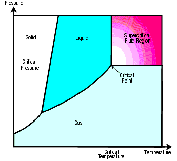
Figure 75: Supercritical Fluid Region. Most of us were taught as children that pure substances can be one of three forms: a solid, liquid, or gas. Usually omitted was a fourth form: supercritical fluids. Although supercritical fluids were discovered in 1822, even teachers are usually unaware of their existence. Any pure substance (such as water, carbon dioxide, or lead) is supercritical when its pressure and temperature exceed those of its critical point—the pressure-temperature combination at which the density of the liquid and vapor are equal. The critical point for water is 705°F (374°C) and 3,200 psi (220.6 bars). For carbon dioxide, the critical point is 88°F (31°C) and 1,072 psi (74 bars).
62. Each liquid droplet is compressed by the surface tension of its “skin,” similar to the stretched rubber of a balloon compressing the air inside the balloon. The pressure increase is inversely proportional to the droplet’s radius. Because the liquid droplets in supercritical fluids are so small, these intermolecular forces are huge. Therefore, the liquid’s pressure and “boiling point” are much greater than one might expect, so even at very high temperatures, the droplets can remain in the liquid state. Therefore, SCW cannot boil.
63. “When the solid is precipitated by suddenly reducing the pressure, it is crystalline, and may be brought down as a ‘snow’ in the gas, or on the glass as a ‘frost,’ but it is always easily redissolved by the gas on increasing the pressure.” J. B. Hannay and James Hogarth, “On the Solubility of Solids in Gases,” Proceedings of the Royal Society, Vol. 29, 1879, p. 326.
64. Extremely high-velocity water droplets can cut steel and other hard solids, much as a knife cuts butter.
65. In 1964, one of the first solids dissolved in a SCF for economic purposes was caffeine from coffee beans. This produced decaffeinated coffee. Organic wastes and toxic substances (such as the agents in chemical weapons) can be dissolved in SCFs and rendered harmless. The SCF is usually carbon dioxide (CO2), because it is cheap, nontoxic, nonflammable, and its critical point, 88°F (31°C) and 1,072 psi (74 bars), is so low.
66. Sanjay Limaye, as quoted by Dennis Normile in “Japanese Probe Primed for a Second Run at Venus,” Science, Vol. 350, 4 December 2015, p. 1142.
u “... the drivers [of this super-rotation] remain mysterious.” Paul Voosen, “Jilted Again, Venus scientists Pine for their Neglected Planet,” Science, Vol. 355, 13 January 2017, p. 116.
67. Vibrating hydroplates are explained in “Water Hammers and Flutter Produced Gigantic Waves” on page 197.
68. Elizabeth Gibney, “Rescued Akatsuki Spacecraft Delivers First Results from Venus,” Nature, Vol. 532, 14 April 2016, p. 157–158.
69. “Heat transfer from a magmatic intrusion to groundwater occurs at depths below drilled geothermal reservoirs and, due to a lack of direct observations, the deep, very high-temperature parts of geothermal systems are not well understood.” Samuel Scott et al., “Geologic Controls on Supercritical Geothermal Resources above Magmatic Intrusions,” Nature Communications, Vol. 6, 27 July 2015, p. 2.
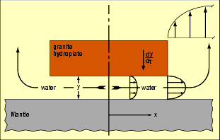
70. Even if the water trapped in the spongelike pockets was not forced back into the subterranean chambers, the plate would settle very slowly, for other reasons. Consider a semi-infinite hydroplate, settling at a rate ![]() and overlying a water layer of thickness y. A water particle exactly below the center of the plate will not move, because it is “undecided” whether to flow to the right or left, but the farther a particle is from the center, the faster it will flow. A simple conservation-of-mass calculation shows that a typical water particle at a distance x from the plate’s center will move with a velocity of
and overlying a water layer of thickness y. A water particle exactly below the center of the plate will not move, because it is “undecided” whether to flow to the right or left, but the farther a particle is from the center, the faster it will flow. A simple conservation-of-mass calculation shows that a typical water particle at a distance x from the plate’s center will move with a velocity of![]() .
.
The water’s steadily increasing speed and decreasing pressure in the downstream direction expanded the water and produced increasing viscous flow resistance and back pressure from that expansion. Also, the increasing load of sediments, especially from crushed pillars, slowed the flow.
Because the water’s pressure decreases in the direction of flow, edges of the hydroplate have less pressure support from below (blue vertical arrows in Figure 77). The plate became concave downward. Flow below the plate is in converging channels, and therefore, subsonic, until the edge of the plate is reached. This edge becomes the throat (shown in red) of a converging-diverging “nozzle.” There the flow is choked; that is, it cannot exceed the relatively slow velocity of sound in water. However, as water passes that constriction, it accelerates supersonically. (For details, consult any textbook on compressible flow.) The volume of water accelerates upward and expands powerfully, because so much nuclear energy (in the form of heat and pressure) was added to that water as it escaped from under the crust. [See "The Origin of Earth’s Radioactivity" on pages 378–414.] As the plate settles toward the chamber floor, the throat’s area narrows, so the volume flow rate out from under the plate decreases, causing the plate to settle even more slowly.
Velocity and erosion from the upward expanding flow will increase as the top of the plate is approached. When the plate finally settles onto the chamber floor, it will have a continental shelf and a continental slope. [See Figures 44, 47, and 61.]
71. T. McKenny Hughes, “Bursting Rock Surfaces,” Geological Magazine, Vol. 3, 1887, pp. 511–512.
72. J. P. Den Hartog, Advanced Strength of Materials (New York: McGraw-Hill, 1952), pp. 141–171.
73. John Larsen, “From Lignin to Coal in a Year,” Nature, Vol. 314, 28 March 1985, p. 316.
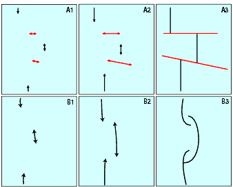
Figure 78: Growth of Two Types of Cracks along Mid-Oceanic Ridge. Figures A1–A3 illustrate the growth of fracture zones (shown in red) and the formation of the offset pattern all along the Mid-Oceanic Ridge. [Compare A3 with Figure 44 on page 112.] If no cracks form perpendicular to the rising ridge, as shown in B1–B3, the axial rifts will often grow past each other, forming overlapping spreading centers as shown in B3 and in Figure 46 on page 114.
74. Compressed solids, liquids, and gases store energy. Springs are common examples. If a force, F, compresses some material by a small amount, D, the additional energy stored in the material is F × D. If the compressed material is rock, D will be small, but F will be huge. The product of the two could be very large. The compressive energy stored in the Earth’s mantle and core is immense.
Just before the rupture, the strain energy in the crust would have been about 1.2 × 1030 ergs. The released energy, as the Mid-Oceanic Ridge sprung upward, was about 1033 ergs. (This is explained beginning on page 132.) Only a small fraction of this energy was needed to form mountains. (In International Standard Units, a 1-megaton hydrogen bomb releases 4.184 × 10²² ergs of energy.) Two of the most violent volcanic eruptions in modern times, Tambora in 1815 and Krakatau in 1883, released about 8.4 × 1026 ergs and 1025 ergs, respectively.) [Gordon A. Macdonald, Volcanoes (Englewood Cliffs, New Jersey: Prentice-Hall, 1972), p. 60.]
75. Pillars (places where the crust sagged slightly and touched the chamber floor) did provide resistance, but only initially. Sliding pillar bases would have instantly become hot liquid magma, which is itself slick.
76. As the Mid-Oceanic Ridge rose, its surface stretched in two perpendicular directions. Because rock is weak in tension, two types of cracks grew, each perpendicular to a direction of stretching. Both types of cracks are shown in Figures 44, 65, 66f, and 78.
Just as the tops of the spring’s coils are farther apart on page 132 in (c) than (a) or (b), so the surface of the ridge was stretched perpendicular to its axis. One can also feel this type of stretching by grabbing a phone book firmly in both hands and arching it. The outer cover is placed in tension.
The other type of stretching was along the ridge axis. A circle’s circumference increases as its radius grows. Likewise, the entire length of the ridge’s crest was stretched as the ridge moved farther from the center of the Earth.
Each type of crack began as a microscopic opening with stress concentrations at both ends. As the ridge rose, both types of cracks grew perpendicular to each other. Cracks along the ridge axis, called axial rifts, began at different locations along the ridge crest. Later, flank rifts, also parallel to the ridge axis, formed farther down the flanks of the ridge. Axial rifts formed before flank rifts because the greatest curvature, and therefore, greatest tension, occurs at the ridge crest. Rifts stopped growing when they ran into the perpendicular cracks called fracture zones. However, fracture zones never ran into axial rifts, because fracture zones always began at the crest, where the ridge was farthest from the center of the Earth. [See A1–A3 in Figure 78.] Both types of cracks are still growing, although sporadically and at a much slower rate. This is due to cooling and thermal contraction, and it accounts for much earthquake activity along the ridge.
As the ridge rose, hundreds of short axial rifts began growing at different places along the rupture path. The more the ridge rose, the longer and wider these cracks became. This created a line of bending weakness, which caused the ridge to rise symmetrically with the axial rift. In general, each axial rift did not align with the next axial rift, so segments of the Mid-Oceanic Ridge are offset from each other at fracture zones.
Lengthening axial rifts also explain overlapping spreading centers (OSCs), where two portions of the ridge axis overlap. Macdonald and Fox, who first reported on OSCs, demonstrated how the overlaps occur. [See Endnote 7 on page 141.] They took a knife and made two parallel cuts in the top of a block of frozen wax—one cut ahead of the other. The block was then pulled perpendicular to both cuts, causing adjacent cuts to grow slightly past each other. Overlapping ends then turned toward each other. Sometimes they intersected. [See Figure 46 on page 114 and B1–B3 in Figure 78.] This suggests that OSCs were formed by lengthening axial rifts as the ridge rose. OSCs contradict the plate tectonic theory.
Another test of the hydroplate theory vs. the plate tectonic theory concerns the cross-sectional profile of fracture zones. According to the hydroplate theory, fracture zones are tension cracks formed when the ridge suddenly rose and was stretched parallel to the ridge axis. The cracks grew from the surface downward, so their profiles should be V-shaped or trough-shaped. [See Figure 79 (a).] Relatively shallow cracks will be V-shaped; deep cracks will be trough-shaped, because the pressure is so great at the base of the crack that the rock would flow as the sides of the crack are pulled apart. The plate tectonic theory says that a fracture zone formed by horizontal shearing. If so, the profile should look as shown in Figure 79 (b). These two predictions were jointly made on April 30, 1986 with the late Robert S. Dietz, one of the developers of the plate tectonic theory. Bob Dietz and I then set out to learn the actual shape of fracture zones.
The true profiles confirm the hydroplate prediction. [See Tjeerd H. van Andel et al., “The Intersection between the Mid-Atlantic Ridge and the Vema Fracture Zone in the North Atlantic,” Journal of Marine Research, Vol. 25, 15 September 1967, pp. 343–351. See also A. A. Meyerhoff and Howard A. Meyerhoff, “Tests of Plate Tectonics,” Plate Tectonics: Assessments and Reassessments, editor Charles F. Kahle (Tulsa: American Association of Petroleum Geologists, 1974), p. 108.]
This exercise produced two other surprising confirmations of the hydroplate theory. First, the actual fracture zones were trough-shaped near the ridge axis where the fractures should be deepest. At the ends of fracture zones, the profiles were V-shaped. The second surprise was the presence of undeformed, layered sediments inside fracture zones. If opposite sides of a fracture zone are sliding past each other, as plate tectonics claims, sediments caught between the sliding plates would be highly deformed.
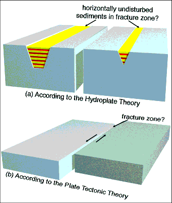
Figure 79: Two Possible Cross Sections of Fracture Zones. Figure 45’s description on page 113 explains why fracture zones have less mass along their lengths. Water-saturated sediments, shown in red and yellow layers in Figure (a) above, are much less dense than the crystalline rock below the ocean floor. Therefore, only Figure (a) explains the large absence of mass along fracture zones.
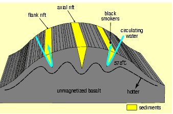
Plate tectonic theory predicts and, some textbooks erroneously claim, that earthquakes in fracture zones occur only between the two offset ridge axes, where the plates, according to plate tectonics, are moving in opposite directions. To the contrary, earthquakes occur all along fracture zones, as the hydroplate theory predicts.
77. Basalt is highly magnetic because it contains magnetite and hematite. Magnetic material will lose its magnetism if its temperature exceeds a certain value called the Curie Point. Increasing the pressure on these minerals raises the Curie Point. At the Earth’s surface, the Curie point for basalt is near 578 °C.
A typical cross section of the Mid-Oceanic Ridge is shown in Figure 80. The ridge’s temperature generally increases with depth. However, the walls of the cracks in the Mid-Oceanic Ridge are cooled by cold water circulating down into and up out of them by natural convection. After several thousand years of cooling, the constant temperature line corresponding to the Curie point is shown by the dashed line. As a rock particle cools from 579°C to 577°C, for example, it takes on the magnetism of the Earth’s magnetic field at that point. Therefore, more magnetized material lies between each crack. Magnetic anomalies also occur perpendicular to the ridge, along fracture zones. According to plate tectonics, such perpendicular magnetic anomalies should not exist. Naturally, if a device measuring magnetic intensity (a magnetometer ) is towed across the ridge, it will show the magnetic anomalies of Figure 48 on page 115. These magnetic anomalies, however, are not magnetic reversals.

PREDICTION 6: Fracture zones and axial and flank rifts will always be along lines of high magnetic intensity.
PREDICTION 7: The magnetic intensity above black smokers slowly increases because the rock below, fractured since the flood a few thousand years ago, is cooling.
78. Other factors complicate the movement.
i. The rupture didn’t necessarily widen by the same amount all along its path.
ii. The Mid-Oceanic Ridge, especially in the Pacific, would not exactly follow the path of the rupture.
iii. A large plate moving over the Earth’s surface is actually part of a spherical shell rotating about an imaginary axis passing through the center of the Earth. Points on the plate far from the poles of that axis move farther and faster than those near the poles.
iv. Depending on exactly where the Mid-Atlantic Ridge began to rise, the hydroplates would not necessarily slide perpendicular to the entire Mid-Atlantic Ridge. In fact, the Americas Plate rotated about 10° clockwise during its slide, and the European-Asian-African Plate rotated about 10° counterclockwise. (This implies that the Mid-Atlantic Ridge began to rise south of the centers of mass of each hydroplate, very near the present equator.)
79. See "Highly Compressed Solids" on page 607.
80. Some geologists have wondered if quartz migrated out of the black rock. One look at the sharp boundary between the light veins and dark host rock should eliminate that possibility. Also, quartz is the first common mineral to melt as rock heats up and the last to solidify as it cools.
81. Shearing forces would produce fairly smooth, straight crack patterns, not the “tangled” patterns at the Black Canyon of the Gunnison. Other forces (viscous, thermal, gravitational, electrical, and magnetic stresses) can be eliminated on other grounds. Because few would even entertain them as a means of breaking so much rock, we will not discuss them here.
82. In 1749, Pierre Bouger discovered that the Andes Mountains did not gravitationally attract a plumb bob as much as expected. In 1854, a similar discovery was made concerning the Himalayan Mountains. Geologists then realized that some mass is missing beneath mountains. Since then, more precise measurements on many mountains have confirmed this.

Figure 81: Fixed Spin Axis. Some have expressed surprise that the Earth’s spin axis in Figure 82B would keep its north-south orientation during Earth’s slow 34° – 57° roll. A simple experiment demonstrates this, and shows that one good experiment is worth a thousand expert opinions. Drill two shallow holes on opposite sides of a croquet ball and fill both holes with lead. If the ball is spun with the lead-filled holes not at the equator, the spin axis does not change as the ball quickly rotates so the lead is at the equator. (When spinning, the white stripes reveal the orientation of the ball and axis.) However, the quickest way to understand that the Earth’s spin axis would not change its orientation is to apply the law of the conservation of angular momentum. It assures us that a rigid body’s spin axis will not change unless an external torque acts on the body.
83. “A layer of aqueous fluids could produce the conductance observed in Tibet with a lower fluid fraction and/or layer thickness than considered above for partial melt. For example, a layer only 1.6 km thick containing 10% of 100 S/m brine would be needed to yield the observed 10,000-S conductance.” Wenbo Wei et al., “Detection of Widespread Fluids in the Tibetan Crust by Magnetotelluric Studies,” Science, Vol. 292, 27 April 2001, p. 718.
u “Our results imply that of the order of 10% volume of free aqueous fluids in the Tibetan middle crust produces the observed bright spot reflections. The presence of relatively large quantities of free aqueous fluids, presumably mostly saline supercritical H2O, does not preclude the presence of melt but does constrain the maximum temperature at the bright spots to the wet granite solidus (about 650°C).” Yizhaq Makovsky and Simon L. Klemperer, “Measuring the Seismic Properties of Tibetan Bright Spots: Evidence for Free Aqueous Fluids in the Tibetan Middle Crust,” Journal of Geophysical Research, Vol. 104, No. B5, 10 May 1999, p. 10,795.
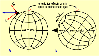
Figure 82: Earth’s Big Roll. (A) If the Earth were a perfect sphere and the black mountain (black triangle) suddenly formed, the spinning Earth would become unbalanced and start “rolling” counterclockwise. This happens because a centrifugal force, shown in blue, acts on the mountain. That blue force is equivalent to the combined forces Hm and Vm (red arrows). Force Hm is always directed toward the new equator, shown in (B). The roll, which rebalances the Earth, would not change Earth’s north-south spin axis or its yearly orbit around the Sun. [See Figure 81.]
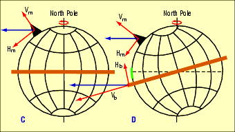
(C) However, the Earth is not a perfect sphere, but has an equatorial bulge, which gives our planet great stability. We can think of the bulge as a big, brown hoop around the equator. This bulge, exaggerated above, is produced by centrifugal forces acting to deform every particle inside the Earth. (D) The more the black mountain rolled the Earth, the more the bulge tilted and the greater its force Hb became. When Hb equaled Hm in magnitude, the roll temporarily stopped. This roll angle was small, because the bulge is so much more massive than any mountain.
The equatorial bulge did not stay tipped, as shown in (D), for long. Remember, the bulge exists because every particle comprising the Earth has its own centrifugal force, which tries to move each particle as far from the Earth’s axis as gravity will allow. Material inside the Earth deformed as the bulge slowly reoriented itself toward a new equator, perpendicular to the north-south spin axis. (The brown hoop can be thought of as slipping over the spherical portion of the Earth toward the new equator when Hb becomes large enough to overcome friction.) Each slight reduction in the bulge’s tilt reduced Hb, so the mountain rolled the Earth another small increment— again counterclockwise. The North Pole, the point where the spin axis penetrates the Northern Hemisphere, shifted. This cycle continued at a diminishing rate until, after a few centuries and 34° – 57° of total roll, all the Earth’s mass was balanced.
Because the diameter of the equatorial bulge is 26.5 miles greater than the polar diameter, the brittle crust stretched and ripped a short distance with each cycle. That rip, shown in green in Figure 82D, began slightly south of the old equator and extend north to and slightly beyond the new equator. Magma quickly flowed up into this rip, which eventually grew 3,000 miles long and is today called Ninety East Ridge. It is inclined 6° to longitude 90°E and can be seen in Figure 44 on page 112. Notice how Ninety East Ridge points toward the Himalayas, Earth’s dominant mountain range, represented by the black mountain in (A)–(D). The rip at 90°E longitude reduced the stress that was tending to cause a similar rip on the opposite side of the Earth.
84. As each mountain quickly rose, its distance from Earth’s spin axis increased. This, in turn, increased the mountain’s centrifugal force (blue arrow in Figure 82A), a force that is always directed away from and perpendicular to the spin axis. (Likewise, a rock whirled at the end of a string produces a centrifugal force that pulls the string taut.)
Part of each new mountain’s centrifugal force acted tangentially to the Earth’s surface and tended to roll the Earth. Because the rising mountains were scattered around the Earth, many of their “rolling” forces counterbalanced each other. However, the Himalayan Mountains and Tibetan Plateau are so massive that their effect dominates that of all other mountains. (The world’s ten highest peaks relative to sea level—including Mount Everest—are part of the Himalayas.) In other words, crashing hydroplates thickened continents and created today’s mountain ranges. Their net centrifugal force, and that of the massive and thickened Eurasian hydroplate, rolled the Earth so that the Himalayas moved toward today’s equator.
Fortunately, the Earth’s spin creates an equatorial bulge that acts like a huge gyroscope stabilizing the Earth. As the Earth began a slight roll immediately after the compression event, the equatorial bulge also rotated, so it was no longer perpendicular to the spin axis. The more the bulge rotated, the more its centrifugal force resisted the rolling force due to the Himalayas and the thickened Eurasian hydroplate. (Please study all of Figure 82.)
The liquid outer core partially isolated the solid inner core from this slow 34° – 57° roll. However, as the outer Earth slipped over the outer core, the core applied a torque on the outer Earth from inside. The law of conservation of angular momentum required the outer Earth’s spin axis to precess, with the North Pole in Figure 82C precessing “into the page.” (The last paragraph in Figure 82 explains the 6° precession that George Dodwell, in the 1930s, discovered by painstakingly analyzing almost 100 ancient astronomical measurements. See “Earth Roll” on page 136.)
The law of the conservation of angular momentum also requires that the total angular momentum of the entire Earth remain constant. Therefore, as the outer Earth (the crust, mantle, and to a large extent the liquid outer core) rolled and precessed, the solid inner core had to role and precess in the opposite direction—but more than a thousand times faster. This was because the inner core’s moment of inertia is less than one thousandth of that of the outer Earth. So, the outer Earth and the inner core developed different spin orientations soon after the compression event. This difference gradually diminished as the liquid in the outer core transmitted torque between the two spinning bodies (the inner core and outer Earth).
The precession, when viewed from above the Indian Ocean, very slowly shifted the Northern Hemisphere to the west and the southern hemisphere to the east. Consequently, that rip has a slight curvature and is not a perfectly straight line. As the rip progressed northward, it curved slightly to the east. This curvature can be seen on very accurate maps of the Indian Ocean floor. For example, Google Earth shows the slight curvature not only at Ninety East Ridge but also along parallel stress fractures east of Ninety East Ridge.
The following chapter (pages 153–190) explains why the Earth’s magnetic field emanates from the inner core. Therefore, the initial precession of the inner core probably produced the rapid drifting of the Earth’s magnetic field described on page 115. The rate of this reverse precession has greatly diminished, but it is probably seen in today’s slight westward drift of the Earth’s magnetic field, the so-called secular variation of the magnetic field.
Earth’s slow roll after the flood steadily changed the paths of the Sun and stars across the sky. That no doubt alarmed the survivors of the flood that had occurred in 3290 B.C. [See p. 484.] Attempts to measure those alarming irregularities led to the construction of Stonehenge, an ancient observatory built between 3000–2480 B.C., 90 years after the flood. [See “Stonehenge Remains Hail from Wales,” Science, Vol. 361,10 August, p.536.]
Besides pushing up mountains, the crashing hydroplates crushed and thickened continents, especially in weak regions. Each plate moving on the surface of a sphere has an axis of rotation. Because the driving forces that moved the two largest hydroplates came from the sudden upbuckling of the same ridge (the Mid-Atlantic Ridge), both hydroplates had almost the same axis of rotation. The fastest plate movement and the most thickening would have occurred near the equator of that axis of rotation. After the compression event, centrifugal forces rolled the temporarily out-of-balance Earth, so the axis of plate rotation approximately aligned with Earth’s spin axis. Therefore, today’s equator approximately bisects and is perpendicular to the Mid-Atlantic Ridge. Since the compression event, isostatic adjustments have smoothed out the Earth’s surface to some extent, but imbalances and adjustments—such as earthquakes—continue within the Earth.
85. As explained in Figure 82, the Himalayas (centered today at 89°E, 33°N) was somewhat south of the old North Pole but near what is now 89°E longitude. Therefore, the Himalayas could have rolled south by as much as 57° (90 – 33 = 57). However, the Himalayas had to roll at least 34° south to shift what is now the southern extreme of Ninety East Ridge (85°E, 34°S) over the equatorial bulge along 90°E longitude. So after the compression event, but before the big roll, the North Pole would have been somewhere on the great-circle segment joining 85°E, 56°N and 89°E, 33°N—basically central Asia.
Ninety East Ridge is a tension fracture from the crust being stretched east and west as it shifted over the equatorial bulge. Today, this stretching may continue and explain why one of the largest earthquakes in recent years occurred near that point on 26 December 2004, causing a tsunami that killed over 230,000 people. The flood is still producing death and destruction. Indeed, all earthquakes, tsunamis, and most other natural disasters are a consequence of the flood.
Just as the Earth roll produced stretching and tearing along Ninety East Ridge, it produced compression and buckling near both poles. At the South Pole, that compression buckled the crust downward, forming a long basin which holds a 76-mile-long subsurface (unfrozen) lake, appropriately named “90°E Lake.” Parallel and adjacent to that lake is another long, subsurface, Antarctic lake named Sovetskaya Lake. An earlier study concluded that these lakes were produced by stresses in the Earth’s crust, not by glacial scouring or meteorite impacts. [See Robin E. Bell et al., “Tectonically Controlled Subglacial Lakes on the Flanks of the Gamburtsev Subglacial Mountains, East Antarctica,” Geophysical Research Letters, Vol. 33, 28 January 2006, pp. L02504–L02507.] Perhaps a compensating upward buckling at the North Pole produced the remarkably straight 1,000-mile-long Lomonosov Ridge.
86. William R. Hammer and William J. Hickerson, “A Crested Theropod Dinosaur from Antarctica,” Science, Vol. 264, 6 May 1994, pp. 828–830.
87. Allan C. Ashworth and F. Christian Thompson, “A Fly in the Biogeographic Ointment,” Nature, Vol. 423, 8 May 2003, p. 135.
88. Anthony R. Fiorillo et al., “Herd Structure in Late Cretaceous Polar Dinosaurs: A Remarkable New Dinosaur Tracksite, Denali National Park, Alaska, USA,” Geology, 30 June 2014.
89. Erin Wayman, “Camel Ancestors Lived in Arctic,” Science News, Vol. 183, 6 April 2013, p. 9.
90. This fossil deposit is located at 14°52'11.34"S, 74°50'06.18"W. For details, see Leonard R. Brand et al., “Fossil Whale Preservation Implies High Diatom Accumulations Rate in the Miocene-Pliocene Pisco Formation of Peru,” Geological Society of America, Vol. 32, February 2004, pp. 165–168.
91. Water degrades rock to clay, either by gently acting on the rock over long time periods or by briefly acting violently—or by some combination of long time or high intensity. Here, a 260-feet-thick deposit of clay, mixed with volcanic ash and diatomaceous earth, has entombed hundreds of whales, 3,800 feet above sea level. This suggests great violence.
92. “The most viable explanation for whale preservation seems to be rapid burial, fast enough to cover whales 5–13 m long and ~50 cm thick within a few weeks or months, to account for whales with well-preserved bones and some soft tissues. Such burial requires diatom accumulation rates at least three to four orders of magnitude faster than is usual in the ocean today—centimeters per week or month, rather than centimeters per thousand years.” Brand et al., p. 167.
93. Smithsonian and National Geographic have sent teams to study this fossil graveyard at 27°03'13.72"S, 70°48'09.13"W. After a year of study, and recognizing the global importance of this site, the researchers admitted they are puzzled.
94. This burial site is only 150 feet above sea level, but some water and animals would have drained from as high as the top of the Andes—22,000 feet above sea level—down narrow ravines and into and out of depressions (temporary ponds).
95. Why are the fossilized whales mostly baleen whales? Baleen whales take large gulps of food and water, and then expel the water through filters in their mouths called baleen plates. If the water was thick with diatomaceous earth and other sediments stirred up by water flowing off a rapidly rising mountain during the compression event, those filters would tend to clog up, so the baleen whales would choke and die.
96. Kenneth M. Reese, “Workers Find Whale in Diatomaceous Earth Quarry,” Chemical and Engineering News, Vol. 54, 11 October 1976, p. 40.
On 7 April 1986, I contacted Lawrence G. Barnes of the Natural History Museum of Los Angeles County, the scientist who excavated this fossilized whale from a quarry for diatomaceous earth. He said the whale was lying parallel to strata that had been tipped up 60° from the horizontal. Only the front half of the whale was recovered. At the time, it was stored in a warehouse and had not been cleaned up. He also saw other whales in the quarry along with a small seal, fish, and birds. The quarry, elevation 238–530 feet above sea level, is at 34°37'30.40"N, 120°29'01.79"W.
97. Obviously, the whale was rapidly and catastrophically buried in an approximately horizontal position; then those layers and the whale were tipped up by 60°. This is completely consistent with the compression event. Richard H. Tedford and C. Richard Harington, “An Arctic Mammal Fauna from the Early Pliocene of North America,” Nature, Vol. 425, 25 September 2003, pp. 388–390.
98. L. David Mech, “Life in the High Arctic,” National Geographic, Vol. 173, June 1988, p. 757.
99. A. Hope Jahren, “Humidity Estimate for the Middle Eocene Arctic Rain Forest,” Geology, Vol. 31, May 2003, pp. 463–466.
u See also Endnote 15 on page 141.
100. Charles Berlitz, The Lost Ship of Noah: In Search of the Ark at Ararat (New York: G. P. Putnam’s Sons, 1987), p. 126.
101. David Warner Mathisen, The Mathisen Corollary (Paso Robles, California: Beowulf Books, 2011).
102. When stocking Lake Titicaca with trout in 1939, officials noticed the presence of Orestias, a genus of killifish. How did killifish get into such a remote lake, 2.3 miles above sea level—naturally, or by man? Humans have little desire for killifish for food or sport. Besides, men would have difficulty keeping any fish or their eggs alive while transporting them by foot from some distant source to Lake Titicaca. Did the fish swim there? Hardly. Because of strong winds, intense sunshine, and low atmospheric pressure, 95% of Lake Titicaca’s water leaves by evaporation. Only 5% trickles into a distant, shrinking, brackish lake with no outlet to the sea.
Evidently, Lake Titicaca rose along with the Andes. Did this happen thousands or millions of years ago? Knowing how rapidly environments can change and destroy habitats, one would be wise to bet on a recent date.
103. For details, see William Ryan and Walter Pitman, Noah’s Flood (New York: Simon & Schuster, 1998). These authors correctly conclude that the Mediterranean Sea breached its boundary, carved the Bosporus and Dardanelles Straits, and flooded the shores of the Black Sea—which was previously predicted and explained by the hydroplate theory. [See prediction 5 on page 140. “The channel cut through bedrock” and formed a “gorge more than 350 feet deep” (p. 65).
Ryan and Pitman incorrectly conclude that this led to the “myth” of Noah’s flood. Instead, the local flood they discovered around the Black Sea was a consequence of the global flood, and bears no resemblance to many details in famous flood legends, secular or otherwise. Nor would any local flood explain the uncanny similarity of flood stories in almost every ancient culture around the world. A global flood does. Furthermore, a child could have walked away unscathed from Ryan and Pitman’s flood, which they admit rose only 6 inches a day. No doubt, the Middle East has experienced many local floods. Why pick one and claim that it led to the world-famous story of Noah’s flood?
104. A buried, 125-mile-long, 650-foot-deep channel across the Gibraltar Strait shows that the Atlantic Ocean spilled into the Mediterranean Basin at 1,000 times the flow rate of the Amazon River. [See D. Garcia-Castellanos et al., “Catastrophic Flood of the Mediterranean after the Messinian Salinity Crisis,” Nature, Vol. 462, 10 December 2009, pp. 778–781.]
105. Aaron Micallef, et al., “Evidence of the Zanclean Megaflood in the Eastern Mediterranean Basin,” Scientific Reports, Vol. 8, 18 January 2018, pp. 1-8.
106. Corings into the portion of the Mid-Oceanic Ridge beneath the Arctic Ocean have revealed ferns and algae that required these warm temperatures.
... extremely warm polar temperatures indicate that, despite much recent progress, feedbacks responsible for early Palaeogene mid- to high-latitude warmth remain poorly understood and are not implemented in existing climate models. Appy Sluijs et al., “Subtropical Arctic Ocean Temperatures during the Palaeocene/Eocene Thermal Maximum,” Nature, Vol. 441, 1 June 2006, p. 612.
u Chert forms when silica precipitates from sea water. The ratio of oxygen-18 to oxygen-16 in chert indicates that the water temperatures were once as high as 60-80 degrees C. This is confirmed independently by silicon isotopes ratios as well. [See Christina L. De La Rocha, “In Hot Water,” Nature, Vol. 443, 26 October 2006, pp. 920–921.]
107. An “El Niño” is the sudden warming of waters in the western Pacific. Today, it occurs every few years and alters climate worldwide, especially precipitation rates.