Below is the online edition of In the Beginning: Compelling Evidence for Creation and the Flood,
by Dr. Walt Brown. Copyright © Center for Scientific Creation. All rights reserved.
Click here to order the hardbound 8th edition (2008) and other materials.
1. Calculations in Table 7 were provided by Bryan Nickel.
2. “Though scientists have studied the canyon for more than 150 years, a definitive answer as to how or when the canyon formed eludes them. The one thing scientists do agree on is that the canyon was carved by the erosive power of the Colorado River, but the river itself has carried away the evidence of its earlier history.” Wayne Ranney, Carving the Grand Canyon: Evidence, Theories, and Mystery (Grand Canyon, Arizona: Grand Canyon Association, 2005), back cover.
u “Grand Canyon is somewhat unique among our national parks because of the lack of a single, scientific theory regarding its origin.” Ranney, p. 20.
3. Ranney, p. 11.
4. The length of the Grand Canyon (216 miles) should not be confused, as it often is, with the combined length (277 miles) of the Grand Canyon plus Marble Canyon. Both lie within Grand Canyon National Park.
5. Bruce Babbitt, Grand Canyon: An Anthology (Flagstaff, Arizona: Northland Press, 1978), p. 50.
6. “... the suspended load carried by the river is prodigious. For the water year ending September 30, 1957, this load averaged more than 425,000 tons a day, or almost five tons each second. ... Average figures for a 50-year span are even higher—about 550,000 tons per day ....” John S. Shelton, Geology Illustrated (San Francisco: W. H. Freeman and Co., 1966), p. 30.
u Some have joked that the Colorado River is too thick to drink, but too thin to plow.
7. Layers of volcanic ash were found and dated in the limestone. [See Jon E. Spencer et al., “40Ar/39Ar Geochronology of the Hualapai Limestone and Bouse Formation and Implications for the Age of the Lower Colorado River,” Colorado River: Origin and Evolution, editors Richard A. Young and Earle E. Spamer, proceedings of a symposium held at Grand Canyon National Park in June 2000 (Grand Canyon, Arizona: Grand Canyon Association, 2001), pp. 89–91.]
u Stephen B. Castor and James E. Faulds, “Post-6 Ma Limestone along the Southeastern Part of the Las Vegas Valley Shear Zone, Southern Nevada,” in Young and Spamer, pp. 77–79.
8. R. J. Rice, “The Canyon Conundrum,” The Geographic Magazine, Vol. 55, June 1983, pp. 288–292.
u “... the Hualapai [Limestone] contains no evidence for a major river emptying into the lake in which the limestone precipitated.” Ivo Lucchitta, “History of the Grand Canyon and of the Colorado River in Arizona,” Grand Canyon Geology, editors Stanley S. Beus and Michael Morales (New York: Oxford University Press, 2003), p. 270.
9. “Probably the most interesting discovery is that a canyon as deep and impressive as the Grand Canyon can be carved in just a few [1.7–4.5] million years—even in rocks that do not yield easily to erosion.” Ivo Lucchitta, Canyon Maker: A Geological History of the Colorado River (Flagstaff, Arizona: Museum of Northern Arizona, 1988), p. 30.
10. These rocks are of three types: (1) rim gravels, (2) a type of lava that caps gravel and colluvium, and (3) a debris fan that spilled out of Pierce Canyon and is deposited across the mouth of the Grand Canyon. [For details, see Lucchitta, “History of the Grand Canyon and of the Colorado River in Arizona,” pp. 269–270.]
11. According to one famous geologist, no Colorado River sediments existed even 1,800,000 years ago.
Did the Colorado River exist anywhere in Pliocene time? If not, how and when may it have come on the scene? ... There are, so far as known, no true river deposits older than Pleistocene along the entire course of the Colorado River—that is, deposits of the specific type that such a river normally lays down. Eliot Blackwelder, “Origin of the Colorado River,” Bulletin of the Geological Society of America, Vol. 45, 30 June 1934, pp. 554, 557.
12. “Under ordinary circumstances an uplifted plateau acts as a barrier to a river’s course, causing it to flow around that barrier through lower ground. Rivers do not normally flow into elevated plateaus but the Colorado River is not a normal river. It appears to cut right through this uplifted wall of rock, which lies three thousand feet above the adjacent Marble Platform to the east. This odd scenario was the foremost problem recognized by the very first geologists who saw the Grand Canyon. Why does the Colorado River seem to flow into the heart of an uplifted plateau?” Ranney, p. 22.
13. The 1989 Information Please Almanac (Boston: Houghton Mifflin Co., 1989), p. 544.
14. The entrance to Grand Canyon Caverns is located at 35°31'42.25"N, 113°13'59.81"W. The red smoke exited at 36°20'44.86"N, 112°43'17.78"W and undoubtedly traveled along Havasu Fault, which also exits at that point. [See Gary A. David, “A Dilemma of Horns,” Four Corners Magazine, February-March 2006, p. 4. Also see Pam Powers, Recollections of the Grand Canyon Caverns (Peach Springs, Arizona: Grand Canyon Caverns & Inn, 2006), pp. 4, 43. ]
15. “Additionally, in Marble Canyon, many tributary streams come into the Colorado River flowing generally to the north, against the southerly flow of the modern [Colorado] river. This creates a pattern of drainage known to geologists as ‘barbed’ tributaries. The Marble Platform, into which the tributaries have been carved, also slopes down to the northeast exactly opposite the flow direction of the modern river.” Ranney, p. 23.
16. Troy L. Péwé, Colorado River Guidebook (Phoenix: Sims Printing Co., Inc., 1969), p. 44. (Péwé showed me these dense boulder fields, but unfortunately I took no pictures.)
u For excellent pictures and locations of these boulders and a detailed description of the Nankoweap Delta area, see Richard Hereford et al., “Quaternary Geology and Geomorphology of the Nankoweap Rapids Area, Marble Canyon, Arizona,” U.S. Geological Survey, Report 502, 1998, pp. 1–18 and the accompanying map: 1-2608.
17. All dimensions for this profile were taken from Profile B–B' on the outstanding “Geologic Map of the Eastern Part of the Grand Canyon,” 1986 edition, produced by the Grand Canyon Association.
18. For an interesting description of this arching, see, Stanley S. Beus and Michael Morales, Grand Canyon Geology (New York: Oxford University Press, 1990), p. 5.
19. Along the Bright Angel Trail, from top to bottom, those thick limestone layers are Kaibab Limestone (350 feet), Toroweap Formation (250 feet), Redwall Limestone (450 feet), Temple Butte Limestone (35 feet), and Muav Limestone (375 feet). Limestone forms only in the presence of water, but earth’s sedimentary rocks contain so much limestone that if limestone formed in shallow seas, those waters would need to be toxic a thousand times over. [See pages 261–266.]
20. “The forces that drove rock uplift of the low-relief, high-elevation, tectonically stable Colorado Plateau are the subject of long-standing debate.” Mousumi Roy et al., “Colorado Plateau Magmatism and Uplift by Warming of Heterogeneous Lithosphere,” Nature, Vol. 459, 18 June 2009, p. 978.
21. “Another curiosity with the Colorado River’s course is that it disregards the fault lines that cross its path. ... The Colorado River within the Grand Canyon crosses dozens of faults, many of them at right angles, ....”Ranney, p. 22.
u Several of these more prominent, nearly vertical faults that are perpendicular to the Colorado River are 19-Mile Fault, Bright Angel Fault, Grand Wash Fault, Havasu Fault, Hurricane Fault, Muav Fault, Sevier Fault, Paunsaugunt (PAWN-suh-gant) Fault, and Toroweap Fault. Most of these named faults are more than 50 miles long. Probably most side canyons that are perpendicular to the Colorado River were initiated by faults that are no longer visible.
22. So-called explanations in geology frequently use words that have no basis in physics. For example, powerful movements are simplistically explained as an uplift, collision, subduction, upheaval, drift, tectonics, subsidence, convulsions, orogeny, crustal movements, stresses within the earth, or mountain building. Such vacuous terms avoid a clear description of the forces, mechanisms and energy involved. The emptiness of those words is usually hidden by claiming that the movement occurred over millions or billions of years. Only laymen are impressed. Time is a variable, not a mechanism.
When hearing or reading such terms, one should ask whether a scientific, cause-to-effect understanding exists for the claimed motion.
The hydroplate theory clearly identifies the forces, energy and mechanisms. In most cases, the force is gravity, and the mechanisms and energy involved are consistent with physics and have been seen by most of us on a small scale.
23. “Oddly enough, the Grand Canyon is located in a place where it seemingly shouldn’t be.” Ranney, p. 20.
24. The Glossary of Geology. It defines a plateau as:
Any comparatively flat area of great extent and elevation; specifically, an extensive land region considerably elevated (more than 150–300 meters in altitude) above the adjacent country or above sea level. [See Robert L. Bates and Julia A. Jackson, editors, Glossary of Geology, 2nd edition (Falls Church, Virginia: American Geological Institute, 1980), p. 482.]
25. Alexandra Witze, “Grand Canyon’s High Surroundings May be Product of Continental Lift,” Science News, Vol. 179, 21 May 2011, p. 12.
26. “It doesn’t take millions of years to create an impressive channel. Flowing liquid can do a lot of work in a short period of time.” Alan D. Howard, as quoted by Sid Perkins, “Texas Flood Carves Canyon in Days,” Science News, Vol. 178, 17 July 2010, p. 15.
27. John S. NewBerry, “Part 3: Geological Report,” in Report upon the Colorado River of the West, Explored in 1857 and 1858 by Joseph C. Ives (Washington D.C.: U.S. Government Printing Office, 1861; reprint, Ann Arbor, Michigan. University of Michigan, 2006), pp. 19–20.
28. Ibid., p. 45.
29. “When the geologist J Harlen Bretz proposed in the 1920s that the Channeled Scablands were created by a catastrophic flood, his ideas were attacked relentlessly by geologists who subscribed to the mainstream view that erosion is slow and steady, and who wanted to distance their profession from the notion of a biblical deluge.” Perron, J. Taylor and Jeremy G. Venditti, “Megafloods Downsized,” Nature, Vol. 538, 13 October 2016, p. 174.
30. John Eliot Allen et al., Cataclysms on the Columbia (Portland, Oregon: Timber Press, 1986).
31. John Wesley Powell, The Exploration of the Colorado River and Its Canyons (1875; reprint, New York: Viking Penguin, 1987), pp. 89–90.
32. Carol S. Breed, “A Century of Conjecture on the Colorado River in Grand Canyon,” Four Corners Geological Society Guidebook (Flagstaff, Arizona: Museum of Northern Arizona, 1969), p. 63.
33. S. F. Emmons, “The Origin of Green River,” Science, Vol. 6, 2 July 1897, pp. 19–21.
34. Blackwelder, pp. 551–566.
35. This proposal was the consensus of experts on the Grand Canyon who attended a symposium led by Edwin D. McKee. [See Edwin D. McKee et al., Evolution of the Colorado River in Arizona: A Hypothesis Developed at the Symposium on Cenozoic Geology of the Colorado Plateau in Arizona (Flagstaff, Arizona: Northern Arizona Society of Science and Art, 1964).]
36. Charles B. Hunt, “Grand Canyon and the Colorado River, Their Geologic History,” Geology of the Grand Canyon (Flagstaff, Arizona: Grand Canyon Natural History Association, 1976), pp. 129–141.
37. Ivo Lucchitta, Canyon Maker, pp. 1–32.
u Ivo Lucchitta, “History of the Grand Canyon and of the Colorado River in Arizona,” pp. 260–274.
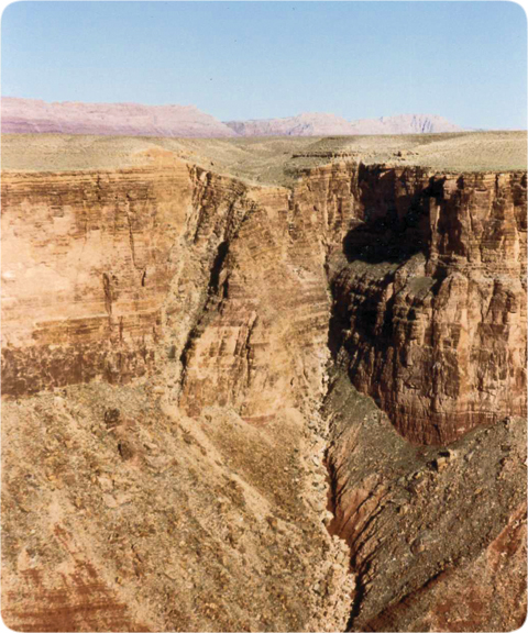
Figure 148: 19-Mile Fault. This fault crosses the Colorado River 19 miles downstream from Lees Ferry, which lies at the north end of the funnel. Here, looking southeast across Marble Canyon and the Colorado River, we can see the vertical line of subsurface drainage and mass removal along 19-Mile Fault. The fault continues along the solid white line shown in Figure 126 on page 224. On the ground, that line is marked by a broad depression (as seen above) and many sinkholes and hollow flow channels, all showing that water drainage removed considerable subsurface mass. At the northwest end of that white line (one mile behind my camera), is Rider Canyon where the fault is again exposed.
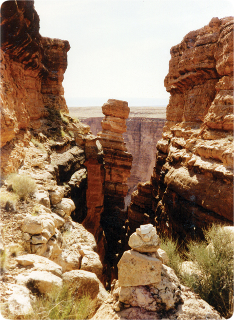
Figure 149: Deep Tension Fractures. Here, the ground split open in several places. (This location is ≠ mile southwest of 19-Mile Fault, and the camera is looking west near the east edge of Rider Canyon.) This deep, 1,500-foot-long crack is almost parallel to Rider Canyon and Marble Canyon. Fifty feet northeast of this crack is a parallel crack; a 500-foot-long parallel crack is on the opposite (west) edge of Rider Canyon. The sides of these cracks have not been offset vertically or horizontally, showing that they are tension fractures. As mass was removed when Rider Canyon and the funnel were rapidly carved, uplift, arching, and stretching occurred—producing the cracks. (The tall block in the center is tipping toward Rider Canyon.)
38. In 1987, after having supper with Larry D. Fellows, the State Geologist for Arizona, I asked him if a fault was in that region. Days later, after checking his files, he told me that he found no record of a fault. However, months later, I found an old river-runner map that showed a fault, called 19-Mile Fault, where the Colorado River crosses the solid white line. During a raft trip down the Colorado River, I verified that the fault existed, but the north side of the fault was lifted only about 100 feet above the south side. [See Figure 148.]
If the fault extended along the dashed white line in Figure 126 on page 224, it would be exposed inside Rider Canyon, the barbed canyon to the northwest. Later, during a trip into Rider Canyon, the fault—and much more—were found!
Between Rider Canyon and Marble Canyon is what I will call a peninsula. If you look closely in Figure 126, you will see that it narrows, or “necks down,” along the solid white line. [See also Figure 125 on page 224.] Along that line are many sinkholes and a long depression. They show that subsurface water drained below that line and removed considerable material, as if the line marked a nearly vertical fault (a plane of weakness, slippage, and drainage). Drainage would have spilled out where the solid-white line segment intersected Marble and Rider Canyons, undercutting and removing material, thereby narrowing (necking) the peninsula.
Also, vertical cracks, several hundred feet deep, have dramatically opened along the edge of Rider Canyon. [See Figure 149.] Some large blocks have fallen, or are about to fall, into Rider Canyon. The tension that split open and formed Marble Canyon no doubt produced these parallel cracks.
If block faulting produced the 2,000-foot Echo-Vermilion Cliff system as the Colorado Plateau was hydraulically uplifted, why was the fault’s offset, as seen at the Colorado River, only about 100 vertical feet and not 2,000 feet? Answer: As Grand Lake’s breaching removed mass south of the funnel, the south side of the fault steadily rose and arched upward, reducing the original offset. More mass was eroded as the ground rose, so even more ground rose. Movement stopped when the south side of the slightly reversed fault slammed into the north side. (Note: For upward movement to occur, block faulting will produce a slightly reversed fault, not a normal fault. Consult a physical geology textbook to understand the difference between normal and reverse faults.)
These discoveries along the solid-white line segment in June 1988, convinced me that block faulting had occurred and that Echo and Vermilion Cliffs had been joined along the dashed white line. (Block faulting obviously occurred at several places directly north in Utah: Book Cliffs, Roan Cliffs, and the Grand Staircase.) The funnel also supports the presence of Grand Lake whose shoreline was 15–20 miles to the northeast. The funnel was carved as Grand Lake breached the 2,000-foot-high Echo-Vermilion Cliff. This led to the formation of Marble Canyon and the Grand Canyon.
39. The steps in the Grand Staircase were lifted sequentially from northeast to southwest, because the buildup of hydraulic pressure from the sinking Rockies would have occurred from northeast to southwest—from the closest point in the Grand Staircase to the Rockies to the farthest point.
40. The coordinates of this location (named Jack Point) are 36°41'56.76"N, 111°37'57.84"W.
41. H. S. Alexander, “Pothole Erosion,” Journal of Geology, Vol. 40, January–December 1932, pp. 305–337.
42. Norman Meek and John Douglass, “Lake Overflow: An Alternative Hypothesis for Grand Canyon Incision and Development of the Colorado River,” in Young and Spamer, pp. 199–204.
43. The Colorado Plateau has been lifted an average of 6,200 feet above sea level, but the portion of the Moho directly below has been correspondingly depressed. [See Professor George C. Kennedy’s statement on page 118.] This means that the plateau was lifted by material injected between the plateau and the Moho.
Several miles above the Moho was the subterranean water chamber. [See Figure 56 on page 127.] The chamber largely collapsed near the end of the flood and became a thin, ready-made conduit, corresponding to the thin, horizontal channel in Figure 130 on page 226. Undoubtedly, some water remained at the floor-roof interface, but even with no water, the collapsed interface was the easiest path for magma to escape from beneath the sinking Rockies.
44. While I follow convention in using the name “Kaibab Plateau,” as geologists and mapmakers have for a century, technically it is not a plateau, but an upwarp. A plateau’s layers are generally horizontal. The upwarp aspect of the “Kaibab Plateau” can be seen easily in the layers in the East Kaibab Monocline that slope downward like a ski slope.
What is a monocline? Lay a book on a table; then drape a handkerchief over the book and onto the table. The handkerchief’s shape is that of a monocline. [See Figure 121 on page 219 and Figure 150 on page 248.]
What caused the bending or warping? The book on the table represents a block that rose by the hydraulic mechanism described in "Plateau Uplift" on page 226. As the block rose, the wet, pliable layers above deformed into the shape of the handkerchief—and became a monocline.
Massive mudslides off the southeast end of the rapidly rising Kaibab Plateau exposed the East Kaibab Monocline. These mudslides are explained in item 13 on page 235.
Several brief conclusions can be drawn concerning the East Kaibab Monocline. A slab of hardened rock cannot be bent into the shape of this monocline without breaking. (I will bypass my page of mathematics showing this. Bending stresses would have fractured a solid slab of this size a hundred times over.) Obviously, the layers comprising the East Kaibab Monocline were wet and unconsolidated when they were bent (warped). After the bending, chemical agents in the water that saturated those sediments cemented them into a solid, but warped, layer.In Figure 121 on page 219, the thinning of the monocline’s layers to the left Figure 121shows that they were originally wet and unconsolidated. This shows where the compression was greatest from the increasing upward hydraulic pressure that fractured the layers, producing the fault and monocline. Downward slumping also contributed to this thinning.
Figure 50 on page 117 shows other flood-deposited layers that were wet and quickly deformed before they were cemented. They and the earth’s major mountains were produced by crashing hydroplates. Immediately afterwards, these mountains began the sinking that pushed up plateaus.

PREDICTION 19: A very deep vertical fault lies beneath the steepest slope in the East Kaibab Monocline. Nonstratified sediments will be found on the downthrow side of the fault. Those sediments washed in to fill the void immediately after the fault formed. The edge of the uplifted block will be found to have slightly cut into the draped layer directly above.
45. Angular rock fragments, called xenoliths (ZEN-oh-liths), are often found in magma flows. These fragments, which are millimeters to meters in diameter, sometimes contain diamonds. Geologists have always had difficulty visualizing how flowing magma could fragment and pluck out pieces of its conduit’s thick wall. It is almost as strange as turning on your faucet and seeing pipe fragments—some of which contain diamonds—spilling into your sink.
Maybe flowing magma did not produce xenoliths. Perhaps some xenoliths were the result of very young, sinking mountains that crushed and slid rocks under great pressure and heat, generating magma—and diamonds.
46. George H. Billingsley, “Volcanic Rocks of the Grand Canyon Area,” in Young and Spamer, pp. 223–229.
47. As magma was produced by the sinking of the Rocky Mountains, water would still have been trapped within the irregularities of the almost-collapsed subterranean water chamber. Water readily dissolves in magma. This lowers magma’s freezing temperature (delays solidification) and makes magma less viscous (easier to flow). Approximately 70% (by volume) of all gases emitted from volcanoes is steam (water vapor). [See Gordon A. Macdonald, Volcanoes (Englewood Cliffs, New Jersey: Prentice-Hall, Inc., 1972), p. 50.]
48. Channels of magma may still connect large areas under the Rocky Mountains with large areas under the Colorado Plateau. If so, magma pressure is still tending to lift blocks in those portions of the Plateau, because the higher (heavier) Rocky Mountains would be exerting greater pressure on the magma than the lower (lighter) Colorado Plateau. Those blocks in the Plateau would be precariously locked by friction. The situation would be similar to a log jam on a large river, except the potential movement would be upward, not horizontal.
This also applies to other plateaus in the world. Removing enough mass from a plateau could destabilize it, the adjacent mountain range, and nearby regions. Seismic shocks, including those passing through the earth, could affect distant plateaus. A nuclear explosion, for example, on a large plateau could produce worldwide earthquakes.
49. Peter W. Huntoon and James W. Sears, “Bright Angel and Eminence Faults, Eastern Grand Canyon, Arizona,” Geological Society of America Bulletin, Vol. 86, April, 1975, pp. 465–472.
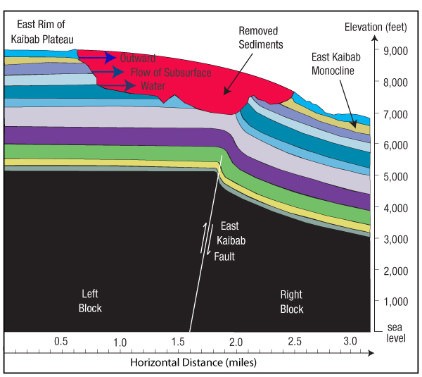
Figure 150: Looking North Along the East Kaibab Fault.17 Lifting of the north-south Kaibab Plateau44 produced many vertical faults. One of the most dramatic was the East Kaibab Fault that parallels the Kaibab Plateau on its eastern slope, but extends farther to the north and south of the plateau. The western side of the fault was first lifted somewhat above the eastern side. Then, subsurface water from the freshly exposed cliff—and sediments eroded by that water (shown in red)—spilled out to the east, shifting weight from the left block to the right block. As explained in "Plateau Uplift" on page 226, both blocks (shown in black) rested on trapped magma below, which allowed even greater displacements and multiple repeats of the cycle. Today, in some places the vertical offset is more than 2,000 feet.
If you squeeze a fist-sized water balloon with both hands, you will notice that a slight increase in pressure on one side of the balloon quickly creates a bulge on another side. Likewise, shifts of weight from the left block to the right block acted quickly on the magma and water saturated sediments below to produce a bulge (or upwarp) under what would become the Kaibab Plateau. Also, as the upward bulge grew, the narrow torrent downstream from Hopi Falls cut down through the rising rock, removing even more weight from the left block and further increasing the Kaibab Plateau’s upwarp. Therefore, today the Colorado River cuts through a mountain.
The major block movements under the Kaibab Upwarp are clearly shown on the better geological maps of the region, but few geologists grasp the forces, energy, mechanism, or timing of these powerful events—or the role of the Rocky Mountains and so much water held within sediments deposited during the flood. Because most geologists hide their unknowns behind millions of years, refuse to consider the flood, and use impressive sounding (but vague) terminology, few scientists or laymen ever wonder or learn what happened.
50. See, for example, Tunnel Overlook at 36°09'00.77"N, 109°31'27.41"W.
51. A mesa is an erosional feature, not an uplifted region as is a plateau. A plateau’s exposed layers correspond to those below the land surrounding the plateau. Plateaus are usually higher and wider than a mesa.
52. Millions of years or several weeks? Anyone giving the first answer would not be expected to provide specific details and evidence, because these features allegedly formed so long ago. Mentioning a few obscure technical words is usually sufficient. Besides, we have such difficulty imagining millions of years that we might be impressed that “science” has supposedly figured it out. Writers often capitalize on this impression by beginning their stories with dramatic, technical-sounding phrases, such as “Millions of years ago, ... .”
Conversely, a person giving the second answer, which opposes conventional opinion and is shocking to some, is frequently expected to quickly provide convincing details and evidence. Despite this double standard, careful readers of this chapter will see the details and evidence for young ages, and why the Grand Canyon and surrounding features were carved in weeks—only a few thousand years ago.
53. “... silicification is an impermeation (void-filling), not an organic replacement, process.” Anne C. Sigleo, “Organic Geochemistry of Silicified Wood, Petrified Forest National Park, Arizona,” Geochimica et Cosmochimica Acta, Vol. 42, September 1978, p. 1404.
54. A saturated solution contains the maximum amount of a dissolved solid, liquid, or gas under equilibrium conditions at a given temperature and pressure.
55. Not all sand is weathered rock. Some sand grains precipitated directly out of the silica-rich flood waters.
56. “Preservation of such detail usually requires rapid infiltration of the petrifying material. If any of the tissues had already decomposed, mineral matter would have simply filled the hollow spaces left behind, preserving the wood’s form but not its cellular structure.” George Sheng, “Turning to Stone,” Science 82, Vol. 3, March 1982, p. 69.
u “... silica nucleation and deposition can occur directly and rapidly on exposed cellulose surfaces.” Sigleo, p. 1404.
57. Robert O. Fournier and Jack J. Rowe, “The Solubility of Amorphous Silica in Water at High Temperatures and High Pressures,” American Mineralogist, Vol. 62, October 1977, pp. 1052–1056.
58. As subterranean water, saturated with silica and other minerals, escaped, its pressure and temperature rapidly dropped. Some water evaporated, but the liquid water remaining was supersaturated with silica. Dissolved silica particles would have been “frantically looking for” the tiniest cracks where they could come out of solution.
59. “The majority of these trees [in Petrified Forest National Park] were very tall. On the average the logs are about 80 to 100 feet long and three to four feet in diameter, but some range up to 200 feet in length and ten feet in diameter at the base.” Sidney Ash, Petrified Forest: The Story Behind the Scenery (Holbrook, Arizona: Petrified Forest Museum Association, 1985), p. 20.
60. Petrified Forest National Park plans to more than double its area. The park’s southern half will expand to the east and west. As one would expect, the expansion is all within the boundary of the former Hopi Lake.
61. The hard rock is Shinarump Conglomerate. Shinumo Altar is located at 36°26'16.59"N, 111°43'11.19"W.
62. Eric Donovan, Personal communication, 5 September 2006.
63. Richard Foster Flint, Glacial and Quaternary Geology (New York: John Wiley & Sons, 1955), pp. 249-250.
64. This pit is located at 36°44'50.70"N, 109°35'10.36"W.
65. To be complete, both parts of this question (how and when) must be answered. Geologists feel that the “when” has already been answered; namely, “the Colorado Plateau was lifted during the last 80-million years.” By locking in the timing before understanding the mechanism, they have become blinded to the physics involved. As Ranney states:
The exact reason why uplift [of the Colorado Plateau] has occurred in the Grand Canyon region remains speculative but certainly the area has been significantly elevated since the sea last left the area about 80-million years ago. Ranney, p. 44.
66. About 29% of the earth’s surface is above sea level. The average elevation of land above sea level is 840 meters, or 2,756 feet. Therefore, pushing all land beneath the sea would raise sea level only 0.29 × 2,756 feet (or 800 feet).
67. Under Grand and Hopi Lake were thick water-saturated sedimentary layers. Once the lakes began their rapid drainage, that subsurface water (no longer contained by as high a water pressure) began escaping upward along the easiest escape routes. That began the deep erosion of lake-bottom sediments.
68. Two varieties of squirrels, which today live in only a few distinct locations worldwide, occupy the Grand Canyon region: the white-tailed Kaibab squirrel north of the canyon and the dark-tailed Abert squirrel south of the canyon. They are obviously related and, except for coloring, are indistinguishable. Each lives on an isolated plateau separated by several hostile environments and the 277-mile-long and several-miles-wide Grand and Marble Canyons. How could even one squirrel (let alone a male and female) traverse that formidable barrier? Probably the Grand Canyon was cut a few thousand years ago through an area occupied by the common ancestors of the Kaibab and Abert squirrels. Since then, the two isolated populations, unable to interbreed and with slightly different gene pools, developed different coloring—a classic case of microevolution (not macroevolution). [See John R. Meyer, “Origin of the Kaibab Squirrel,” Creation Research Society Quarterly, Vol. 22, September 1985, pp. 68–78.]
u Stewart Aitchison, a prominent Grand Canyon researcher, explains a related problem:
“[Both] squirrels occur only where there are ponderosa pine forests, for they depend almost exclusively on that particular pine species for food and nest building. ... Ponderosa pines probably did not spread into northern Arizona (presumably from the south) until the waning days of the last ice age. The Grand Canyon is at least several million years old. So how and when did the squirrel follow? So far, these are unsolved mysteries.” Stewart Aitchison, Grand Canyon’s North Rim and Beyond (Grand Canyon, Arizona, Grand Canyon Association, 2007), p. 24.
The mystery is easily solved. The Grand Canyon is not millions of years old. It is only about 5,000 years old.
69. The Navajo legend may give another reason for dating the Grand Canyon at least a few centuries after the global flood.
A great [local] flood threatened to drown the Navajo’s ancestors. Suddenly an outlet was formed by rushing waters. The Navajo survived the flood by being transformed temporarily into fish. The outlet the flood waters formed is the Grand Canyon. Dan Goldblatt, Grand Canyon, Great National Parks Series (Pleasantville, New York: The Reader’s Digest Association, Inc., 1988), video.
This legend implies that a local flood inundated northern Arizona. (Was it from the breaching of Grand and Hopi Lakes?) Survivors discovered the newly formed Grand Canyon, still carrying runoff from that local flood. If the legend is even partially true, the Grand Canyon formed recently, while people occupied that area, not millions of years ago.
Descendants of other early Americans who live near the Grand Canyon have similar legends that tell of a large flood. The Hualapai legend says that the Creator sent word to dig a huge hole to drain the land. As the waters receded, the Grand Canyon was left behind. The Havasupai tribe also tells of the Grand Canyon forming after a single, catastrophic flood. [See Ranney, pp. 84–85.]
70. This also applies if only the portion of the Colorado Plateau that held Grand or Hopi Lake tipped by 0.1°. If a block inside the lake tipped by this amount, shorelines would change to a lesser extent. Within Grand Lake’s basin are large blocks that are faulted and tipped by many degrees. One example is Book Cliffs, so named because they resemble a row of books that partially toppled onto their sides after a bookend was removed. The 250-mile-long Book Cliffs are the longest continuous escarpment in the world.
71. Edmond W. Holroyd, III, “A Remote Sensing Search for Extinct Lake Shore Lines on the Colorado Plateau,” Proceedings of the Third International Conference on Creationism (Pittsburgh, Pennsylvania: Creation Science Fellowship, Inc., 1994), pp. 243–254.
72. Ibid., p. 245.
73. These narrow slot canyons [on the Colorado Plateau] are among the strangest, most-interesting and fotogenic features on earth. ... There is simply no other place on earth quite like the Colorado Plateau.” Michael R. Kelsey, Technical Slot Canyon Guide to the Colorado Plateau (Provo, Utah: Kelsey Publishing, 2008), p. 7.
74. M. S. Steckler et al., “Multi-Channel Seismic Reflection Database for the Northern Gulf of California, a Highly-Sedimented Oblique Rift,” Geophysical Research Abstracts, Vol. 5, 2003, pp. 1–2.
75. “... the submarine canyons in the Gulf of California exist only at the southern end.” Charles A. Anderson et al., “1940 E. W. Scripps Cruise to the Gulf of California,” Geological Society of America Memoir 43 (New York: Geological Society of America, 1950), p. 361.
76. “Our preferred interpretation of the Chemehuevi Formation is that it contains the remnants of deposits formed during a single major episode of fluvial aggradation [sediment deposition by river flooding], during which the Colorado River filled its valley with a great volume of dominantly sand-size sediment.” Daniel V. Malmon et al., Stratigraphy and Depositional Environments of the Upper Pleistocene Chemehuevi Formation along the Lower Colorado River, Geological Survey Professional Paper 1786 (Washington, D.C.: U.S. Government Printing Office, 2011), p. 2.
u Wood found buried in the deposited sediments was dated at 35,100 radiocarbon years. [See Malmon et al., p. 16.] As explained in "How Accurate Is Radiocarbon Dating?" on pages 523–527, an age of 40,000 radiocarbon years corresponds to about 5,000 actual years—the time of the flood. Apparently, the carving of the Grand Canyon was at least several centuries after the flood.
77. “[William Morris Davis] and his followers found peneplains often in the geologic past, but, tellingly, nowhere in the present. The paradigm of a geologic cycle ending in a peneplain was to dominate the theory of physical geology for half a century.” James Lawrence Powell, Grand Canyon: Solving Earth’s Grandest Puzzle (New York: Pi Press, 2005), p. 155.
u “... modern geologists do not find peneplains.” Ibid., p. 156.
78. Ranney, p. 23.
79. “New 3Hec [cosmogenic] and 39Ar/40Ar [argon-argon] ages show that volcanism and lava damming in this region occurred between 1 and 630 ka [1,000–630,000 years ago], rather than between 10 ka and 1.8 Ma [10,000–1,800,000 years ago based on potassium-argon dating] as previously reported.” Cassandra R. Fenton et al., “Geochemical Discrimination of Five Pleistocene Lava-Dam Outburst-Flood Deposits, Western Grand Canyon, Arizona,” Journal of Geology, Vol. 112, 2004, p. 91.
u “K-Ar dating of basalts in the Uinkaret volcanic field is known to be problematic owing to excess 40Ar incorporated into large phenocrysts from the magmatic environment and abundant glassy groundmass. Anomalously old ages for young basalts in other volcanic fields have been attributed to excess argon and low potassium concentrations.” Cassandra R. Fenton et al., “Cosmogenic 3He Dating of Western Grand Canyon Basalts,” in Young and Spamer, p. 147.
80. “Let us turn from speculation to what we can say with confidence. It is that the ultimate cause of the Grand Canyon is plate tectonics.” James Lawrence Powell, p. 252.
81. [Once upon a time] “some 30 million years ago the Farallon Plate lay between the American and Pacific Plates. The two converged along a subduction zone that gradually consumed the Farallon Plate. By about 20 million years ago, it had vanished, leaving behind two smaller remnants: the Juan de Fuca and Cocos Plates. The Farallon Plate eventually traveled east for 1,500 kilometers, so far underneath North America that it caused the uplift of the Rocky Mountains.” Ibid., p. 213.
82. Ivo Lucchitta, “Development of Landscape in Northwest Arizona: The Country of Plateaus and Canyons,” Landscapes of Arizona: The Geological Story, editors T. L. Smiley et al. (London: University Press of America, 1984), pp. 269-301.
u See Endnote 88.
83. James Lawrence Powell, p. 191.
84. Ibid., p. 256.
85. “There is no obvious reason to expect more rapid headward erosion from the drainage that became the Colorado River because this drainage incised the same rock units at Pigeon, Hidden, and Hobble Canyons farther north, descended from cliffs of similar or lower height, reached the same structural trough, and was subjected to the same climatic conditions.” Jon E. Spencer and Philip A. Pearthree, “Headward Erosion Versus Closed-Basin Spillover as Alternative Causes of Neogene Capture of the Ancestral Colorado River by the Gulf of California,” in Young and Spamer, p. 218.
86. “The idea of McKee and others that this basin received flow from the upper ancestral Colorado River cannot be justified based on ... the lack of basin accumulation space for the assumed sediment carrying capacity of an ancestral upper Colorado River.” Todd A. Dallegge et al., “Age and Depositional Basin Morphology of the Bidahochi Formation and Implications for the Ancestral Upper Colorado River,” in Young and Spamer, p. 51.
87. Hunt, p. 137.
88. “But both authors [McKee and Hunt] had arrived at their theories partly by elimination and partly by inference: no direct evidence ever turned up to support either.” James Lawrence Powell, p. 206.
89. “However, the Hualapai is not restricted to the mouth of the Grand Canyon, but occurs over a wide area. It also contains evidence suggesting deposition in a number of separate lakes. It is difficult to attribute all these lakes to springs near the mouth of the Grand Canyon resulting from piping of the Colorado. Furthermore, the Hualapai does not occur only at the top of the interior-basin sequence, as stated by Hunt, but throughout the exposed section [in some layers below the top].” Lucchitta, “Development of Landscape,” p. 294.
90. James Lawrence Powell, p. 200.
91. Ibid., p. 205.
92. “Geologist George Billingsley mapped these same plateaus without finding outcrops of confirmed river gravel. As with the McKee and Hunt theories, the key evidence that would support Lucchitta’s idea has yet to appear, though it still could.” James Lawrence Powell, p. 210.
93. KTIS Radio, Minneapolis, Minnesota, 16 September 1988.
94. Walt Brown, In the Beginning, 5th edition (Phoenix: The Center for Scientific Creation, 1989), pp. 75–76, 83.
95. R. B. Scarborough, “Cenozoic Erosion and Sedimentation in Arizona,” Arizona Bureau of Geology and Mineral Technology, 16 November 1984.
96. Notice that the hydroplate theory explains how the Kaibab Upwarp formed as a result of the breaching of Grand and Hopi Lakes, and why the torrent of escaping waters cut down through that mountain as it rose. In other words, right after Grand and Hopi Lakes breached, the Kaibab Upwarp, the Colorado River, and the Grand Canyon began forming.
Austin, on the other hand, does not explain the Kaibab Upwarp, but believes it existed before the breaching. He wonders how the escaping waters of a lake cut through that mountain.
97. On pages 53-55 of Austin’s 1989 Grand Canyon Guidebook is the almost identical chapter that was in his 1988 Guidebook, “Evidences for Relic Landscape and Youthful Canyon.” In it was one surprising addition—Holroyd’s map showing where a lake larger than Grand and Hopi Lakes combined would have been, if a gigantic, mile-long dam stretched across the Grand Canyon at Grand Canyon Village. Might Austin have done that because Holroyd’s hypothetical lake was close to what Austin had just learned I was teaching in seminars and a radio program (broadcast over 200 stations on 16 September 1988) about Grand Lake and the origin of the Grand Canyon? On page 68 of Austin’s 1990 Guidebook is Holroyd’s same map, and on page 78 it is shown again as “Grand and Hopi Lakes.”
Holroyd’s one-page map and its caption was clearly a last minute addition to Austin’s 1989 Guidebook, because nowhere else in the chapter was it (or any related details) mentioned or explained, something careful authors or the discoverer of Grand Lake would not omit. Perhaps this last-minute addition was made because Austin, who had been trying to explain Grand Canyon’s origin for years, suddenly felt “scooped.” Was this a way he could claim that in 1989 he had proposed a specific lake (with an elevation of 5,700 feet) that breached and thereby carved the Grand Canyon?
But if Austin published his conclusions in 1989, that would not be soon enough, because I had been teaching and broadcasting my explanation in 1988—a broadcast whose audio recording—dated by the radio station—I still possess. Austin needed to claim that his discoveries were made in 1988. Therefore, he deceptively placed a 1988 copyright date in his Guidebook—a book obviously printed in 1989, based on other dates in his book.
Austin certainly developed an interest in what I was saying because he quickly purchased my July 1989 book in August 1989, a month after it came off the printing presses. [Steve Austin, personal correspondence, 29 August 1994]. Later, Austin also used, without attribution in his 1990 Guidebook, the location, breach point, and elevation of Grand Lake that I discovered in 1986–1987.
Surprisingly, Austin never included a picture or mentioned the funnel—a steep, 18-mile long spillway that widened to 12 miles at its low (downstream) end. When I studied it from the ground in 1986–1987, it was obviously a massive erosion feature that required the sudden release of a large lake’s worth of water to carve. That feature alone dramatically shows that a gigantic lake breached. Austin was too capable a geologist to ignore such a feature, if he had seen it from the ground before 1989. In September 1992, a camera man on Gentry’s television crew and I and flew over the funnel in a rented plane to get good pictures of it for television.
98. Today, the world’s largest lake a mile or more above sea level is Lake Titicaca on the border of Bolivia and Peru in the Andes Mountains. Lake Titicaca holds only 15% the water that was in Grand Lake—not to mention Hopi Lake. [See page 139.]
Had the Colorado Plateau risen slowly as it lifted Grand and Hopi Lakes, the lakes would have rapidly shrunk (and maybe disappeared), because at high elevations there is rapid evaporation and little rain. However, in less than an hour (during the compression event) the Rocky Mountains were buckled up and then the Colorado plateau and its two big lakes began to rise hydraulically. [See pages 499 and 226.] Again, it is hard to see how the Grand Canyon could be explained without details provided by the hydroplate theory.
99. By adding Holroyd’s map to that chapter, Austin created several problems for himself, revealed his duplicity, and left his fingerprints. First, he had to remove one page to compensate for the added one-page map, otherwise he would have to renumber almost 200 subsequent pages in his Grand Canyon Guidebook, or reprint all those pages. Reprinting would have taken several hours with the Radio Shack daisy-wheel printer he used. Evidently, to save time, work, and expense, he simply removed four endnotes from pages 55 and 56, since they are read less frequently, and are less critical to the chapter’s message. Unfortunately, he had to paste over page numbers in that chapter that needed changing because of the added map. Revealing these last-minute problems was one paste-over that was cockeyed, an error a computer or typesetter would not have made.
100. When I pointed this out to Austin, he claimed that he accidently put the wrong copyright page in his 1989 Guidebook. If so, Austin is admitting that the ideas in his August 1989 Guidebook were dated in 1989, after my 1988 broadcasts and seminars.
101. If anyone feels that this unfortunate situation should be corrected, and they can set up a publicly available, videotaped, face-to-face meeting with Austin or an ICR representative and me, I will make every effort to attend.
Alternatively, if Austin or the President of ICR apologizes and acknowledges the above in writing, the matter will be removed from my book. A similar offer was made to Austin before the 8th edition was published in 2008 and the President of ICR, Henry Morris III, on 12 September 2018. Unfortunately, they ignored my offers.